File:Hunsrück - Deutsche Mittelgebirge, Serie A-de.png
Alkuperäinen tiedosto (2 100 × 2 100 kuvapistettä, 6,53 MiB, MIME-tyyppi: image/png)
Kuvatekstit
Kuvatekstit
Yhteenveto
[muokkaa]| Kuvaus |
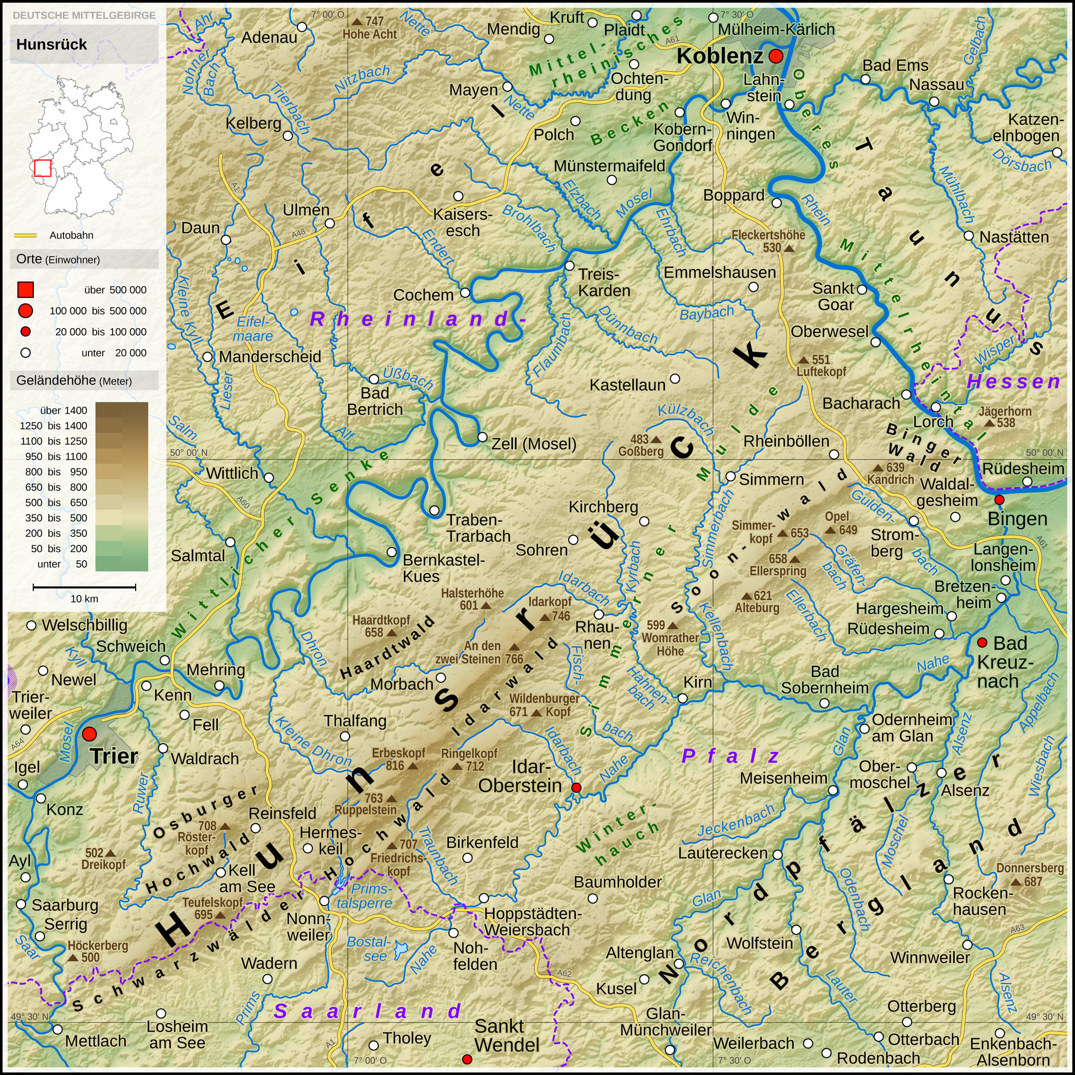
English: Topographic map of the Hunsrück
Deutsch: Topografische Karte des Hunsrück |
||||||||||||||||||
| Päiväys | |||||||||||||||||||
| Lähde |
Own work using: |
||||||||||||||||||
| Tekijä | Thoroe | ||||||||||||||||||
| Muut versiot |
 Topographic maps of German low mountain ranges (A series)
This map series aims to show the major low mountain ranges of Germany in a uniform design. All maps are created on the same scale, and the background reliefs base upon the same color scheme. The reliefs are also available as separate files. You can find the making-of one of the maps in the German language Wikipedia (German only).
|
||||||||||||||||||


_-_Deutsche_Mittelgebirge,_Serie_A-de.png)
_-_Deutsche_Mittelgebirge,_Serie_A-de.png)
_-_Deutsche_Mittelgebirge,_Serie_A-de.png)
_-_Deutsche_Mittelgebirge,_Serie_A-de.png)
_-_Deutsche_Mittelgebirge,_Serie_A-de.png)
_-_Deutsche_Mittelgebirge,_Serie_A-de.png)
_-_Deutsche_Mittelgebirge,_Serie_A-de.png)
_-_Deutsche_Mittelgebirge,_Serie_A-de.png)
_-_Deutsche_Mittelgebirge,_Serie_A-de.png)
_-_Deutsche_Mittelgebirge,_Serie_A-de.png)
_-_Deutsche_Mittelgebirge,_Serie_A-de.png)
_-_Deutsche_Mittelgebirge,_Serie_A-de.png)
_-_Deutsche_Mittelgebirge,_Serie_A-de.png)
_-_Deutsche_Mittelgebirge,_Serie_A-de.png)
_-_Deutsche_Mittelgebirge,_Serie_A-de.png)
_-_Deutsche_Mittelgebirge,_Serie_A-de.png)
_-_Deutsche_Mittelgebirge,_Serie_A-de.png)
_-_Deutsche_Mittelgebirge,_Serie_A-de.png)
_-_Deutsche_Mittelgebirge,_Serie_A-de.png)
_-_Deutsche_Mittelgebirge,_Serie_A-de.png)
_-_Deutsche_Mittelgebirge,_Serie_A-de.png)
_-_Deutsche_Mittelgebirge,_Serie_A-de.png)
_-_Deutsche_Mittelgebirge,_Serie_A-de.png)
_-_Deutsche_Mittelgebirge,_Serie_A-de.png)
_-_Deutsche_Mittelgebirge,_Serie_A-de.png)
_-_Deutsche_Mittelgebirge,_Serie_A-de.png)
_-_Deutsche_Mittelgebirge,_Serie_A-de.png)
_-_Deutsche_Mittelgebirge,_Serie_A-de.png)
_-_Deutsche_Mittelgebirge,_Serie_A-de.png)
_-_Deutsche_Mittelgebirge,_Serie_A-de.png)
_-_Deutsche_Mittelgebirge,_Serie_A-de.png)
_-_Deutsche_Mittelgebirge,_Serie_A-de.png)
| This work contains information from OpenStreetMap, which is made available under the Open Database License (ODbL).
The ODbL does not require any particular license for maps produced from ODbL data. Prior to 1 August 2020, map tiles produced by the OpenStreetMap Foundation were licensed under the CC-BY-SA-2.0 license. Maps produced by other people may be subject to other licences. |

|
Saksankielisen Wikipedian projekti Kartenwerkstatt on parantanut tätä karttaa. Myös sinä voit ehdottaa jotakin karttaa parannettavaksi.
|
Lisenssi
[muokkaa]
- Voit:
- jakaa – kopioida, levittää ja esittää teosta
- remiksata – valmistaa muutettuja teoksia
- Seuraavilla ehdoilla:
- nimeäminen – Sinun on mainittava lähde asianmukaisesti, tarjottava linkki lisenssiin sekä merkittävä, mikäli olet tehnyt muutoksia. Voit tehdä yllä olevan millä tahansa kohtuullisella tavalla, mutta et siten, että annat ymmärtää lisenssinantajan suosittelevan sinua tai teoksen käyttöäsi.
- jaa samoin – Jos muutat tai perustat tähän työhön, voit jakaa tuloksena syntyvää työtä vain tällä tai tämän kaltaisella lisenssillä.
| Annotations | This image is annotated: View the annotations at Commons |
Tiedoston historia
Päiväystä napsauttamalla näet, millainen tiedosto oli kyseisellä hetkellä.
| Päiväys | Pienoiskuva | Koko | Käyttäjä | Kommentti | |
|---|---|---|---|---|---|
| nykyinen | 11. lokakuuta 2017 kello 14.27 | | 2 100 × 2 100 (6,53 MiB) | Thoroe (keskustelu | muokkaukset) | Schriftzug "Soonwald" |
| 13. toukokuuta 2017 kello 10.51 |  | 2 100 × 2 100 (6,53 MiB) | Thoroe (keskustelu | muokkaukset) | Brohlbach (Mosel) korr. | |
| 13. toukokuuta 2017 kello 00.25 |  | 2 100 × 2 100 (6,53 MiB) | Thoroe (keskustelu | muokkaukset) | {{Information |Description ={{en|1=Topographic map of the Hunsrück}} {{de|1=Topografische Karte des Hunsrück}} |Source ={{Own using}} *[http://gmt.soest.hawaii.edu Generic Mapping Tools (GMT)] with [http... |
Et voi tallentaa uutta tiedostoa tämän tilalle.
Tiedoston käyttö
Seuraavat 50 sivua käyttävät tätä tiedostoa:
- File:Bayerischer Wald (Relief) - Deutsche Mittelgebirge, Serie A-de.png
- File:Bayerischer Wald (Relief und Gewässer) - Deutsche Mittelgebirge, Serie A-de.png
- File:Bayerischer Wald - Deutsche Mittelgebirge, Serie A-de.png
- File:Deutsche Mittelgebirge, Serie A - Abdeckung.svg
- File:Eifel (Relief) - Deutsche Mittelgebirge, Serie A-de.png
- File:Eifel (Relief und Gewässer) - Deutsche Mittelgebirge, Serie A-de.png
- File:Eifel - Deutsche Mittelgebirge, Serie A-de.png
- File:Harz (Relief) - Deutsche Mittelgebirge, Serie A-de.png
- File:Harz (Relief und Gewässer) - Deutsche Mittelgebirge, Serie A-de.png
- File:Harz - Deutsche Mittelgebirge, Serie A-de.png
- File:Hunsrück (Relief) - Deutsche Mittelgebirge, Serie A-de.png
- File:Hunsrück (Relief und Gewässer) - Deutsche Mittelgebirge, Serie A-de.png
- File:Hunsrück - Deutsche Mittelgebirge, Serie A-de.png
- File:Oberpfälzer Wald (Relief) - Deutsche Mittelgebirge, Serie A-de.png
- File:Oberpfälzer Wald (Relief und Gewässer) - Deutsche Mittelgebirge, Serie A-de.png
- File:Oberpfälzer Wald - Deutsche Mittelgebirge, Serie A-de.png
- File:Odenwald (Relief) - Deutsche Mittelgebirge, Serie A-de.png
- File:Odenwald (Relief und Gewässer) - Deutsche Mittelgebirge, Serie A-de.png
- File:Odenwald - Deutsche Mittelgebirge, Serie A-de.png
- File:Rhön (Relief) - Deutsche Mittelgebirge, Serie A-de.png
- File:Rhön (Relief und Gewässer) - Deutsche Mittelgebirge, Serie A-de.png
- File:Rhön - Deutsche Mittelgebirge, Serie A-de.png
- File:Rothaargebirge (Relief) - Deutsche Mittelgebirge, Serie A-de.png
- File:Rothaargebirge (Relief und Gewässer) - Deutsche Mittelgebirge, Serie A-de.png
- File:Rothaargebirge - Deutsche Mittelgebirge, Serie A-de.png
- File:Schwarzwald (Relief) - Deutsche Mittelgebirge, Serie A-de.png
- File:Schwarzwald (Relief und Gewässer) - Deutsche Mittelgebirge, Serie A-de.png
- File:Schwarzwald - Deutsche Mittelgebirge, Serie A-de.png
- File:Schwäbische Alb (Relief) - Deutsche Mittelgebirge, Serie A-de.png
- File:Schwäbische Alb (Relief und Gewässer) - Deutsche Mittelgebirge, Serie A-de.png
- File:Schwäbische Alb - Deutsche Mittelgebirge, Serie A-de.png
- File:Spessart (Relief) - Deutsche Mittelgebirge, Serie A-de.png
- File:Spessart (Relief und Gewässer) - Deutsche Mittelgebirge, Serie A-de.png
- File:Spessart - Deutsche Mittelgebirge, Serie A-de.png
- File:Taunus (Relief) - Deutsche Mittelgebirge, Serie A-de.png
- File:Taunus (Relief und Gewässer) - Deutsche Mittelgebirge, Serie A-de.png
- File:Taunus - Deutsche Mittelgebirge, Serie A-de.png
- File:Teutoburger Wald (Relief) - Deutsche Mittelgebirge, Serie A-de.png
- File:Teutoburger Wald (Relief und Gewässer) - Deutsche Mittelgebirge, Serie A-de.png
- File:Teutoburger Wald - Deutsche Mittelgebirge, Serie A-de.png
- File:Thüringer Wald (Relief) - Deutsche Mittelgebirge, Serie A-de.png
- File:Thüringer Wald (Relief und Gewässer) - Deutsche Mittelgebirge, Serie A-de.png
- File:Thüringer Wald - Deutsche Mittelgebirge, Serie A-de.png
- File:Vogelsberg (Relief) - Deutsche Mittelgebirge, Serie A-de.png
- File:Vogelsberg (Relief und Gewässer) - Deutsche Mittelgebirge, Serie A-de.png
- File:Vogelsberg - Deutsche Mittelgebirge, Serie A-de.png
- File:Westerwald (Relief) - Deutsche Mittelgebirge, Serie A-de.png
- File:Westerwald (Relief und Gewässer) - Deutsche Mittelgebirge, Serie A-de.png
- File:Westerwald - Deutsche Mittelgebirge, Serie A-de.png
- Template:Topographic maps of German low mountain ranges (Mittelgebirge), A series
Tiedoston järjestelmänlaajuinen käyttö
Seuraavat muut wikit käyttävät tätä tiedostoa:
- Käyttö sivustolla bg.wikipedia.org
- Käyttö sivustolla br.wikipedia.org
- Käyttö sivustolla cs.wikipedia.org
- Käyttö sivustolla da.wikipedia.org
- Käyttö sivustolla de.wikipedia.org
- Käyttö sivustolla de.wiktionary.org
- Käyttö sivustolla en.wikipedia.org
- Käyttö sivustolla en.wikivoyage.org
- Käyttö sivustolla eo.wikipedia.org
- Käyttö sivustolla es.wikipedia.org
- Käyttö sivustolla fr.wikipedia.org
- Käyttö sivustolla fy.wikipedia.org
- Käyttö sivustolla it.wikipedia.org
- Käyttö sivustolla ja.wikipedia.org
- Käyttö sivustolla la.wikipedia.org
- Käyttö sivustolla lb.wikipedia.org
- Käyttö sivustolla nl.wikipedia.org
- Käyttö sivustolla no.wikipedia.org
- Käyttö sivustolla pt.wikipedia.org
- Käyttö sivustolla ro.wikipedia.org
- Käyttö sivustolla sv.wikipedia.org
- Käyttö sivustolla zh.wikipedia.org