File:Hurricane Helene 2006.jpg
Ir a la navegación
Ir a la búsqueda

Tamaño de esta previsualización: 600 × 600 píxeles. Otras resoluciones: 240 × 240 píxeles | 480 × 480 píxeles | 768 × 768 píxeles | 1024 × 1024 píxeles | 2048 × 2048 píxeles | 7200 × 7200 píxeles.
Archivo original (7200 × 7200 píxeles; tamaño de archivo: 6,67 MB; tipo MIME: image/jpeg)
Leyendas
Leyendas
Añade una explicación corta acerca de lo que representa este archivo
Resumen
[editar]| Descripción |
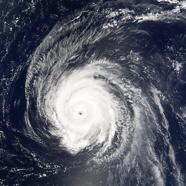
English: The 2006 Atlantic Hurricane season had a slow start, with very few named storms in the first months of the season. But in early September, the previously hurricane-less season threw out four hurricanes in a row: Ernesto, Florence, Gordon, and Helene. A persistent ridgeline of high pressure over the U.S. east coast steered the last three of these four storms away into the North Atlantic. Hurricanes Gordon and Helene have both reached Category Three status. As of September 19, Helene was not expected to make landfall on any of the Atlantic islands, though it may pass close enough to Bermuda to bring strong storm surges.
This photo-like image was acquired by the Moderate Resolution Imaging Spectroradiometer (MODIS) on NASA’s Terra satellite on September 19, 2006, at 10:15 a.m. local time (14:15 UTC). Helene is a well-defined large sprawling storm system with long spirals arms, a tightly wound central portion, distinct eyewall, and a cloud-filled eye. These are all telltale signs of a powerful hurricane. According to the University of Hawaii’s Tropical Storm Information Center, Helene had sustained winds reaching as high as 185 kilometers per hour (115 miles per hour), making it a powerful Category Three storm. As of September 19, Helene was predicted to building power slightly more as it continued to travel over warm seas and with no significant landfalls to disrupt the hurricane’s continued strength. |
|||||
| Fecha | ||||||
| Fuente | http://earthobservatory.nasa.gov/NaturalHazards/natural_hazards_v2.php3?img_id=13880 (archived) → jpg (archived) | |||||
| Autor | NASA image created by Jesse Allen, Earth Observatory, using data provided courtesy of the MODIS Rapid Response team. | |||||
| Permiso (Reutilización de este archivo) |
|

Historial del archivo
Haz clic sobre una fecha y hora para ver el archivo tal como apareció en ese momento.
| Fecha y hora | Miniatura | Dimensiones | Usuario | Comentario | |
|---|---|---|---|---|---|
| actual | 00:20 10 jul 2011 | | 7200 × 7200 (6,67 MB) | Saibo (discusión | contribs.) | Reverted to version as of 22:47, 19 September 2006. Back to non-progressive version |
| 00:18 10 jul 2011 |  | 7200 × 7200 (4,26 MB) | Saibo (discusión | contribs.) | archiving original version (encoded in progressive jpeg) http://web.archive.org/web/20081103110532/http://earthobservatory.nasa.gov/NaturalHazards/natural_hazards_v2.php3?img_id=13880 → http://web.archive.org/web/20071030174144/http://earthobservatory.n | |
| 22:47 19 sep 2006 |  | 7200 × 7200 (6,67 MB) | Good kitty (discusión | contribs.) | == Summary == {{Information |Description=The 2006 Atlantic Hurricane season had a slow start, with very few named storms in the first months of the season. But in early September, the previously hurricane-less season threw out four hurricanes in a row: Er |
No puedes sobrescribir este archivo.
Usos del archivo
Las siguientes páginas usan este archivo:
- 2006 Atlantic hurricane season
- File:HurricaneHelene2006.jpg (archivo de redirección)
Uso global del archivo
Las wikis siguientes utilizan este archivo:
- Uso en de.wikipedia.org
- Uso en en.wikipedia.org
- Uso en es.wikipedia.org
- Uso en fr.wikipedia.org
- Uso en nl.wikipedia.org
- Uso en zh.wikipedia.org