File:Hurricane Hilary Rapidly Intensifies to a Category 4 Storm (53139172274).png
Jump to navigation
Jump to search

Size of this preview: 800 × 450 pixels. Other resolutions: 320 × 180 pixels | 640 × 360 pixels | 1,024 × 576 pixels | 1,280 × 720 pixels | 1,920 × 1,080 pixels.
Original file (1,920 × 1,080 pixels, file size: 2.37 MB, MIME type: image/png)
Captions
Captions
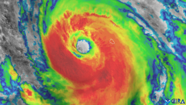
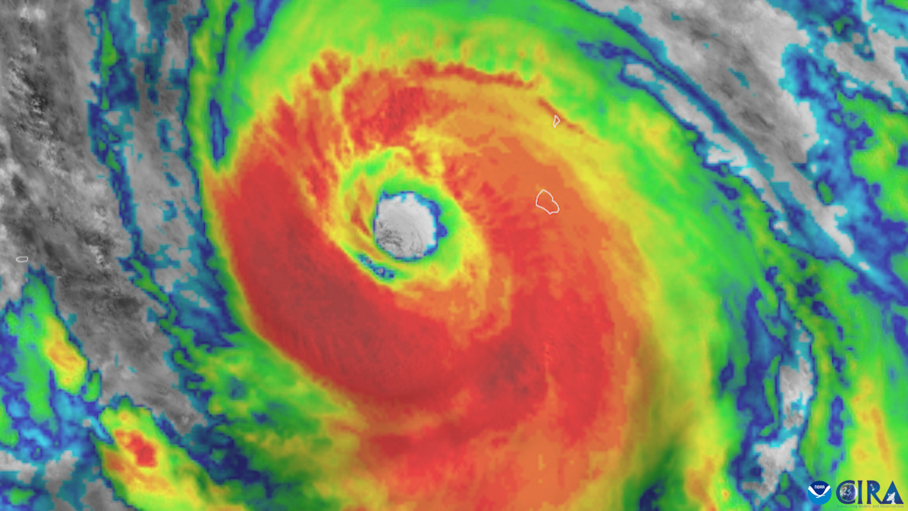
GOES-18 visible and infrared “sandwich” imagery of Category 4 Hurricane Hilary on Aug. 18, 2023. GOES-18 (GOES West) monitored Hurricane Hilary as it rapidly intensified into a Category 4 storm with maximum sustained winds of 145 mph on Aug. 18.

.png&wpForReUpload=1&wpUploadDescription=%5B%5BCommons%3AWatermarks%23Dealing%20with%20watermarked%20images%7Cwatermark%20removed%5D%5D)
.png&action=edit&withJS=MediaWiki:RemoveWatermarktemplate.js)
Summary
[edit].png&action=edit§ion=1)
| Description |
English: GOES-18 visible and infrared “sandwich” imagery of Category 4 Hurricane Hilary on Aug. 18, 2023.
GOES-18 (GOES West) monitored Hurricane Hilary as it rapidly intensified into a Category 4 storm with maximum sustained winds of 145 mph on Aug. 18. That day, the National Hurricane Center (NHC) issued the first-ever tropical storm watch for Southern California. The Weather Prediction Center issued the first-ever level 4 (high risk) for flash flooding in the desert valleys of Southern California. After weakening to a tropical storm, Hilary made landfall in San Quintin, Baja California, on Aug. 20 and moved into Southern California hours later, bringing torrential rainfall, flooding and mudslides. Up to 10.5 inches of rain fell in Southern California, including around 2 to 3 inches in Los Angeles and San Diego, which set summer records. Hillary weakened into a post-tropical cyclone as it crossed the border into Nevada early on Aug. 21. Heavy rainfall and flooding are expected in parts of Arizona and Nevada. GOES-18 data helped forecasters monitor Hilary in real-time and track the storm and estimate its intensity. |
| Date | Taken on 24 August 2023, 13:44:20 |
| Source | Hurricane Hilary Rapidly Intensifies to a Category 4 Storm |
| Author | NOAASatellites |
| Flickr set | GOES-18 (GOES West) Data and Imagery |
| Flickr tags | satellites; goesr; pacifichurricane; hurricane; pacificocean; hurricanehilary; satelliteimagery; noaa; goes18; noaasatellites; goeswest; bestof |
Licensing
[edit].png&action=edit§ion=2)
This image is in the public domain because it contains materials that originally came from the U.S. National Oceanic and Atmospheric Administration, taken or made as part of an employee's official duties.
|
| This image was originally posted to Flickr by NOAASatellites at https://flickr.com/photos/125201706@N06/53139172274. It was reviewed on 19 February 2024 by FlickreviewR 2 and was confirmed to be licensed under the terms of the Public Domain Mark. |
File history
Click on a date/time to view the file as it appeared at that time.
| Date/Time | Thumbnail | Dimensions | User | Comment | |
|---|---|---|---|---|---|
| current | 09:40, 19 February 2024 | | 1,920 × 1,080 (2.37 MB) | OptimusPrimeBot (talk | contribs) | #Spacemedia - Upload of https://live.staticflickr.com/65535/53139172274_365437931a_o.png via Commons:Spacemedia |
You cannot overwrite this file.
File usage on Commons
There are no pages that use this file.
.png&oldid=868677811)