File:Hurricane Isabel NC landfall radar.jpg
跳至導覽
跳至搜尋

預覽大小:685 × 599 像素。 其他解析度:274 × 240 像素 | 549 × 480 像素。
原始檔案 (800 × 700 像素,檔案大小:139 KB,MIME 類型:image/jpeg)
說明
說明
添加單行說明來描述出檔案所代表的內容
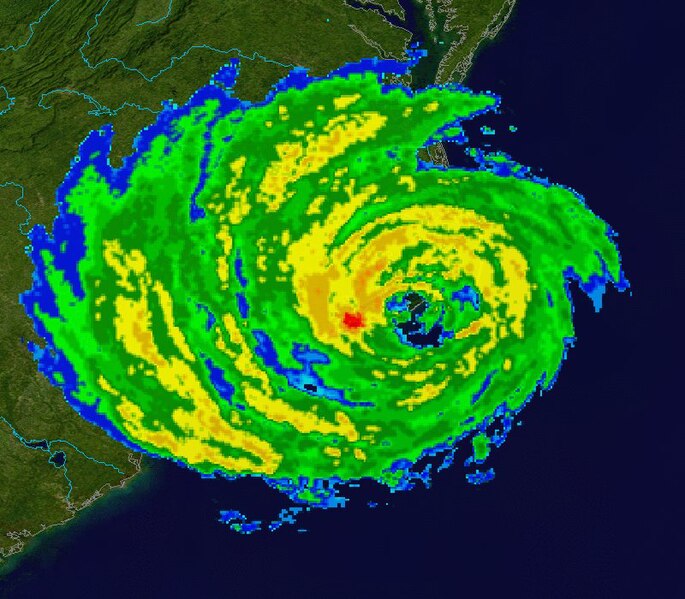
| 描述 | This image shows Hurricane Isabel at 16:59 p.m. EDT on September 18, 2003, as it was making its landfall in North Carolina as a Category 2 Hurricane. The radar data is from the NWS NEXRAD radar at Morehead City. The background is true colour imagery derived from NASA's MODIS satellites. | ||
| 日期 | |||
| 來源 | Radar data from the NCDC NEXRAD database. Background image is NASA Blue Marble imagery. | ||
| 作者 | Composite created by Nilfanion. | ||
| 授權許可 (重用此檔案) |
|
檔案歷史
點選日期/時間以檢視該時間的檔案版本。
| 日期/時間 | 縮圖 | 尺寸 | 使用者 | 備註 | |
|---|---|---|---|---|---|
| 目前 | 2007年1月4日 (四) 17:07 | | 800 × 700(139 KB) | Nilfanion(留言 | 貢獻) | {{Information |Description=This image shows en:Hurricane Isabel at 16:59 p.m. EDT on September 18, 2003, as it was making its landfall in North Carolina as a Category 2 Hurricane. The radar data is from the NWS NEXRAD radar at [[:en:Morehead City, N |
無法覆蓋此檔案。
檔案用途
沒有使用此檔案的頁面。
全域檔案使用狀況
以下其他 wiki 使用了這個檔案:
- en.wikipedia.org 的使用狀況
- es.wikipedia.org 的使用狀況
- zh.wikipedia.org 的使用狀況