File:Hurricane Lane (43580315924).jpg
Original file (2,882 × 2,882 pixels, file size: 1.58 MB, MIME type: image/jpeg)
Captions
Captions
Summary[edit]
.jpg&action=edit§ion=1)
| Description |
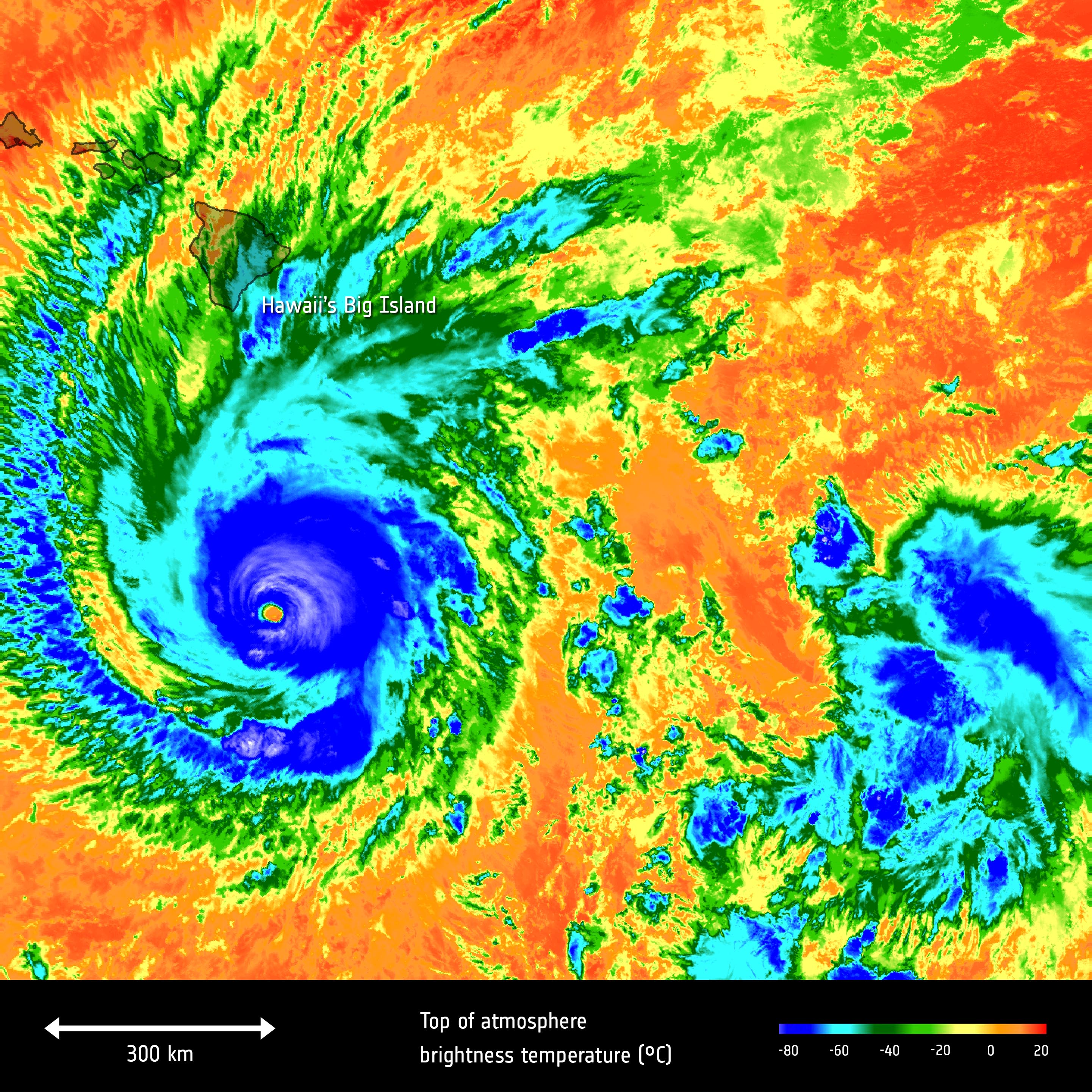
The Copernicus Sentinel-3A satellite took the temperature at the top of Hurricane Lane as it headed towards Hawaii’s Big Island on 22 August 2018. Lane weakened to a Category 3 storm on 23 August, just before it hit Hawaii. Still a powerful storm, it has brought torrential rain to the Big Island. The island is still reeling from months of devastating lava flows from the Kilauea volcano and is now coping with heavy rain and flooding. The brightness temperature of the clouds at the top of the storm, some 12–15 km above the ocean, range from about –80°C near the eye of the storm to about 15°C at the edges. Hurricanes are one of the forces of nature that can be tracked only by satellites, providing up-to-date imagery so that authorities know when to take precautionary measures. Satellites deliver information on a storm’s extent, wind speed and path, and on key features such as cloud thickness, temperature, and water and ice content. Sentinel-3’s Sea and Land Surface Temperature Radiometer measures energy radiating from Earth’s surface in nine spectral bands. Credits: contains modified Copernicus Sentinel data (2018), processed by ESA,<a href="https://creativecommons.org/licenses/by-sa/3.0/igo/" rel="nofollow">CC BY-SA 3.0 IGO</a> |
| Date | Taken on 24 August 2018, 11:59 |
| Source | Hurricane Lane |
| Author | European Space Agency |
| Camera location | | View this and other nearby images on: OpenStreetMap |
|---|
.jpg¶ms=017.455472_N_-155.368652_E_globe:Earth_type:camera_source:Flickr_&language=en)
Licensing[edit]
.jpg&action=edit§ion=2)
- You are free:
- to share – to copy, distribute and transmit the work
- to remix – to adapt the work
- Under the following conditions:
- attribution – You must give appropriate credit, provide a link to the license, and indicate if changes were made. You may do so in any reasonable manner, but not in any way that suggests the licensor endorses you or your use.
- share alike – If you remix, transform, or build upon the material, you must distribute your contributions under the same or compatible license as the original.
| This image was originally posted to Flickr by europeanspaceagency at https://flickr.com/photos/37472264@N04/43580315924 (archive). It was reviewed on 27 August 2018 by FlickreviewR 2 and was confirmed to be licensed under the terms of the cc-by-sa-2.0. |
File history
Click on a date/time to view the file as it appeared at that time.
| Date/Time | Thumbnail | Dimensions | User | Comment | |
|---|---|---|---|---|---|
| current | 15:47, 27 August 2018 | | 2,882 × 2,882 (1.58 MB) | A1Cafel (talk | contribs) | Transferred from Flickr via #flickr2commons |
You cannot overwrite this file.
File usage on Commons
The following 2 pages use this file:
File usage on other wikis
The following other wikis use this file:
- Usage on www.wikidata.org
.jpg&oldid=590318196)