File:Hurricane Maria September 6 2005.jpg
跳转到导航
跳转到搜索

本预览的尺寸:600 × 600像素。 其他分辨率:240 × 240像素 | 480 × 480像素 | 768 × 768像素 | 1,024 × 1,024像素 | 2,048 × 2,048像素 | 6,000 × 6,000像素。
原始文件 (6,000 × 6,000像素,文件大小:4.99 MB,MIME类型:image/jpeg)
说明
说明
添加一行文字以描述该文件所表现的内容
摘要[编辑]
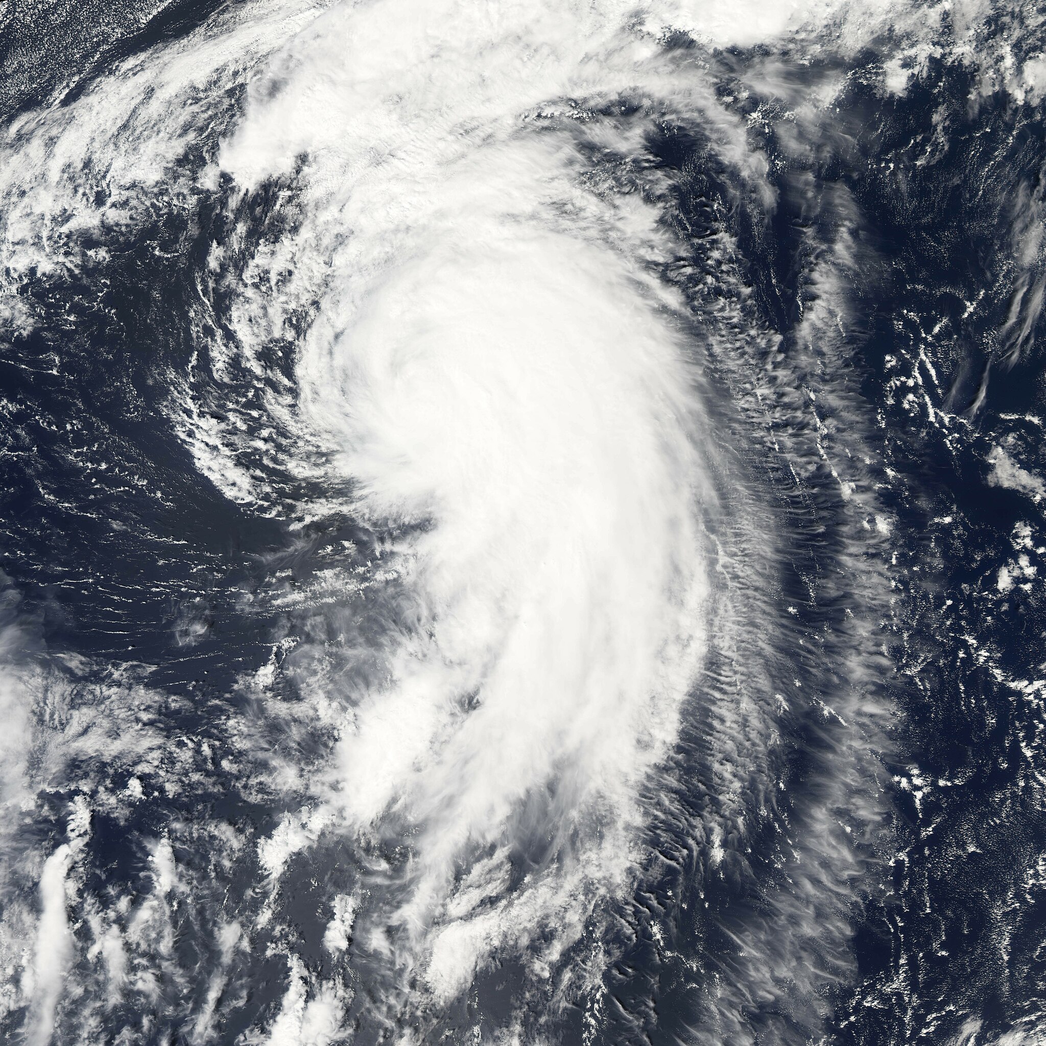
| 描述 | Hurricane Maria is spinning north over the Atlantic Ocean, well away from land. The storm reached its maximum intensity on September 6, 2005, several hours before the Moderate Resolution Imaging Spectroradiometer (MODIS) on NASA’s Aqua satellite captured this image at 1:45 ADT (16:45 UTC). At this time, the storm had winds of about 160 kilometers per hour (100 miles per hour) with gusts to 195 km/hr (120 mph), down from its previous intensity of 185 km/hr (115 mph) with gusts to 220 km/hr (140 mph). Maria is expected to continue to weaken as it moves north. It is not forecast to affect land. | |||||
| 日期 | ||||||
| 来源 | http://earthobservatory.nasa.gov/NaturalHazards/natural_hazards_v2.php3?img_id=13107 | |||||
| 作者 | NASA image created by Jesse Allen, Earth Observatory, using data provided courtesy of the MODIS Rapid Response team. | |||||
| 授权 (二次使用本文件) |
|

文件历史
点击某个日期/时间查看对应时刻的文件。
| 日期/时间 | 缩略图 | 大小 | 用户 | 备注 | |
|---|---|---|---|---|---|
| 当前 | 2006年7月29日 (六) 17:52 | | 6,000 × 6,000(4.99 MB) | Good kitty(留言 | 贡献) | |
| 2006年1月8日 (日) 03:13 |  | 1,500 × 1,500(802 KB) | Jdorje~commonswiki(留言 | 贡献) | ||
| 2005年9月7日 (三) 21:08 |  | 6,000 × 6,000(3.2 MB) | Tom(留言 | 贡献) | {{PD-USGov-NASA}} Hurricane Maria spinning north over the Atlantic Ocean, well away from land. The storm reached its maximum intensity on September 6, 2005, several hours before the Moderate Resolution Imaging Spectroradiometer (MOD |
您不可以覆盖此文件。
文件用途
全域文件用途
以下其他wiki使用此文件:
- de.wikipedia.org上的用途
- en.wikipedia.org上的用途
- eo.wikipedia.org上的用途
- es.wikipedia.org上的用途
- eu.wikipedia.org上的用途
- fr.wikipedia.org上的用途
- pt.wikipedia.org上的用途
- simple.wikipedia.org上的用途
- sv.wikinews.org上的用途
- www.wikidata.org上的用途
- zh.wikipedia.org上的用途