File:Hurricane Orlene (MODIS).jpg

Original file (6,706 × 5,344 pixels, file size: 3.27 MB, MIME type: image/jpeg)
Captions
Captions
Summary
[edit].jpg&action=edit§ion=1)
| Description |
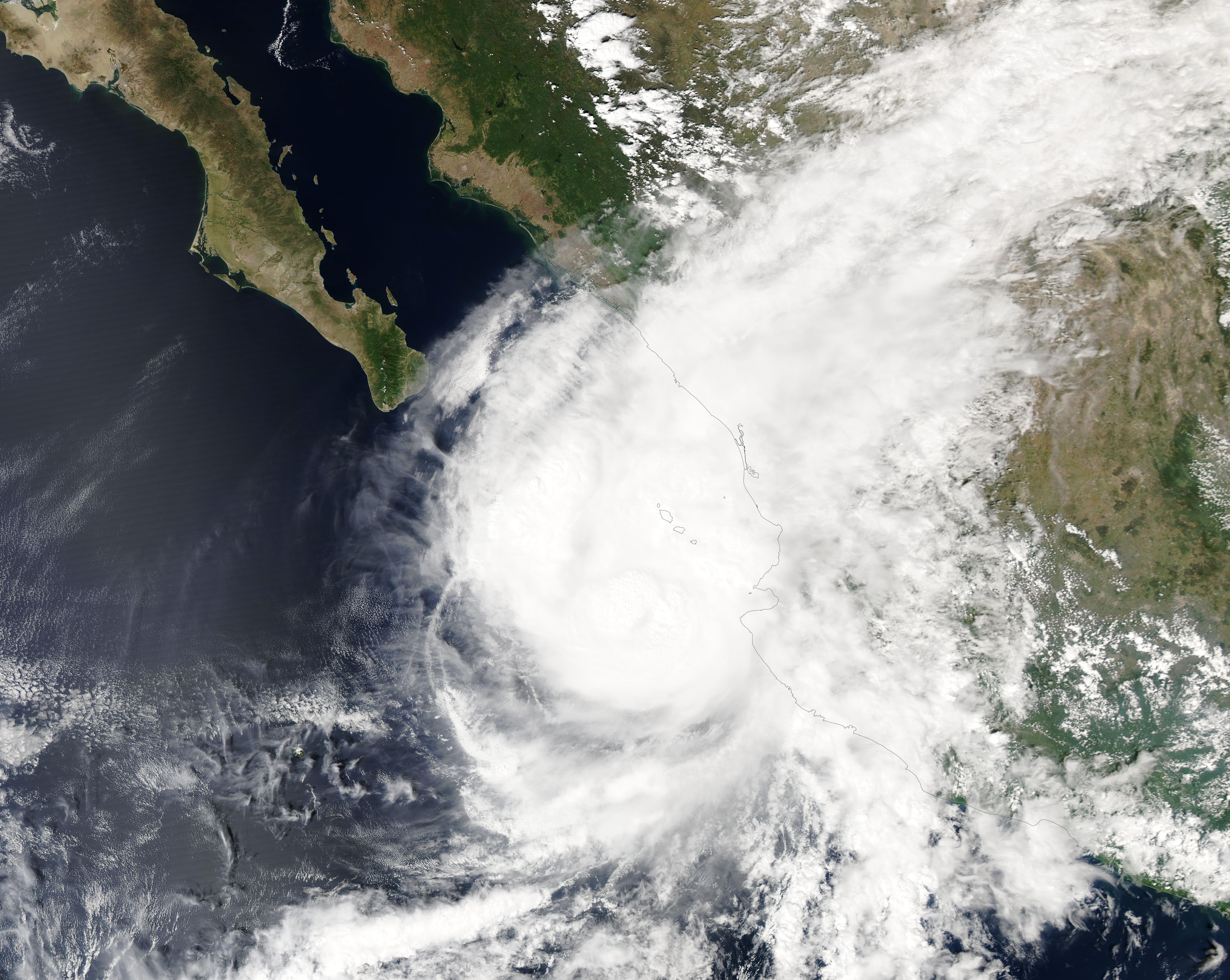
English: Wind shear was beginning to tug at Hurricane Orlene on the afternoon of October 2, 2022, causing windspeeds to drop as the powerful storm approached landfall over Mexico. Orlene started the day as a Category 4 hurricane with maximum sustained winds of 130 mph (209.2 km/h) and slowly weakened throughout the day. It made landfall in southwest Mexico just north of the Nayarit and Sinaloa boarder around 7:45 a.m. local time (9:45 a.m. EDT on October 3 with maximum sustained winds of about 85 mph (140 km/h), or a Category 1 storm on the Saffir-Simpson Hurricane Wind Scale.
The Moderate Resolution Imaging Spectroradiometer (MODIS) on board NASA’s Terra satellite acquired a true-color image of Hurricane Orlene on October 2. At that time, the storm showed an asymmetrical appearance and a cloud-filled eye as rain bands stretched far towards the northeast over the Islas Marias and mainland Mexico. Near the time this image was acquired, the National Hurricane Center (NHC) advised that Hurricane Orlene was located about 80 miles (125 km) west of Cabo Corrientes, Mexico and about 85 miles (135 km) south-southwest of Las Islas Marias, Mexico. The storm was a Category 3 hurricane, carrying maximum sustained winds of 115 mph (185 km/h). Hurricane Orlene quickly dissipated as moved inland on October 3, bringing heavy rain and high winds to west-central Mexico. Flooding has been reported in Mexico especially along the Canas River, thanks to drenching rain brought by the hurricane. |
||
| Date | Taken on 2 October 2022 | ||
| Source |
Hurricane Orlene (direct link)
|
||
| Author | MODIS Land Rapid Response Team, NASA GSFC |
| This media is a product of the Aqua mission Credit and attribution belongs to the mission team, if not already specified in the "author" row |
Licensing
[edit].jpg&action=edit§ion=2)
| This file is in the public domain in the United States because it was solely created by NASA. NASA copyright policy states that "NASA material is not protected by copyright unless noted". (See Template:PD-USGov, NASA copyright policy page or JPL Image Use Policy.) | ||
 |
Warnings:
|
File history
Click on a date/time to view the file as it appeared at that time.
| Date/Time | Thumbnail | Dimensions | User | Comment | |
|---|---|---|---|---|---|
| current | 00:20, 13 September 2023 | | 6,706 × 5,344 (3.27 MB) | OptimusPrimeBot (talk | contribs) | #Spacemedia - Upload of http://modis.gsfc.nasa.gov/gallery/images/image10042022_250m.jpg via Commons:Spacemedia |
You cannot overwrite this file.
File usage on Commons
There are no pages that use this file.
.jpg&oldid=801225532)