File:IAN 0219 Coronelli 1707 Preveza.jpg
(Redirected from File:IAN 0219.jpg)

Size of this preview: 800 × 570 pixels. Other resolutions: 320 × 228 pixels | 640 × 456 pixels | 1,024 × 729 pixels | 1,280 × 912 pixels | 2,560 × 1,824 pixels | 5,120 × 3,647 pixels.
Original file (5,120 × 3,647 pixels, file size: 3.2 MB, MIME type: image/jpeg)
Captions
Captions
Add a one-line explanation of what this file represents
Summary[edit]
| Title |
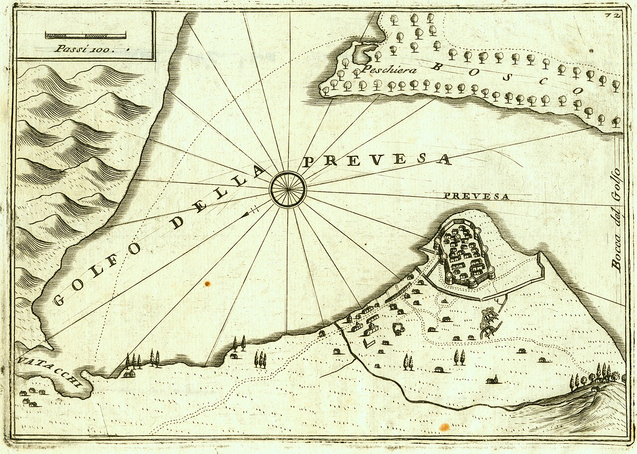
Italiano: Golfo della Prevesa. English: The Gulf of Preveza. Ελληνικά: Ο κόλπος της Πρέβεζας. |
||||||||||||||||||||||||||
| Description |
English: The Gulf of Preveza with the castle of Bouka and the city of Preveza. Copper engraving by Vincenzo Maria Coronelli, 1707 c. Nikos D. Karabelas map collection, Actia Nicopolis Foundation, Preveza, Greece.
Ελληνικά: Ο κόλπος της Πρέβεζας, με το κάστρο της Μπούκας και την πόλη της Πρέβεζας. Χαλκογραφία του Βιντσένζο Μαρία Κορονέλλι του 1707 περίπου. Συλλογή χαρτών Νίκου Δ. Καράμπελα, Ίδρυμα Ακτία Νικόπολις, Πρέβεζα |
||||||||||||||||||||||||||
| Date | circa 1707 | ||||||||||||||||||||||||||
| Source | Coronelli Vincenzo Maria, Citta, Fortezze, ed altri Luoghi principali Dell’ Albania, Epiro e Livadia, E particolarmente I posseduti da Veneti Descritti e Deleneati dal P. Coronelli, Venice, c. 1707. Map. No.72. | ||||||||||||||||||||||||||
| Creator |
|
||||||||||||||||||||||||||
| Permission (Reusing this file) |
This file is licensed under the Creative Commons Attribution 4.0 International license.
| ||||||||||||||||||||||||||
| Attribution (required by the license) | |||||||||||||||||||||||||||
| Geotemporal data | |||||||||||||||||||||||||||
| Date depicted | 1684, when the Venetians captured Preveza for the second time. | ||||||||||||||||||||||||||
| Map location | Preveza, Greece | ||||||||||||||||||||||||||
| Map type | nautical chart | ||||||||||||||||||||||||||
| Spatial reference system | Mercator | ||||||||||||||||||||||||||
| Scale | Passi 100 | ||||||||||||||||||||||||||
| Heading |
 |
||||||||||||||||||||||||||
| Bounding box |
|
||||||||||||||||||||||||||
| Georeferencing | If inappropriate please set warp_status = skip to hide. | ||||||||||||||||||||||||||
| Bibliographic data | |||||||||||||||||||||||||||
| Part of the series |
English: Actia Nicopolis Foundation, Preveza, Greece. Nikos D. Karabelas map collection. Ελληνικά: Ίδρυμα Ακτία Νικόπολις, Πρέβεζα. Συλλογή χαρτών Νίκου Δ. Καράμπελα. |
||||||||||||||||||||||||||
| Map sheet | IAN 0219 | ||||||||||||||||||||||||||
| Language | Italian | ||||||||||||||||||||||||||
| Archival data | |||||||||||||||||||||||||||
| Collection |
|
||||||||||||||||||||||||||
| Accession number |
IAN_0219 |
||||||||||||||||||||||||||
| Dimensions | height: 128 mm (5.03 in); width: 184 mm (7.24 in) | ||||||||||||||||||||||||||
| Medium |
English: Copper engraving. Ελληνικά: Χαλκογραφία. |
||||||||||||||||||||||||||
| Inscriptions | Golfo della Prevesa, Vatacchi, Prevesa, Bocca del Golfo, Peschiera, Bosco | ||||||||||||||||||||||||||
| Notes | Watermark with Fleur de lis and vertical lines at approximately every 25 mm | ||||||||||||||||||||||||||


- Error in {{Map}} template: unknown parameter "1", "2", "3", "4", "5", "6", "7", "8".
File history
Click on a date/time to view the file as it appeared at that time.
| Date/Time | Thumbnail | Dimensions | User | Comment | |
|---|---|---|---|---|---|
| current | 09:33, 26 November 2015 | | 5,120 × 3,647 (3.2 MB) | Actia Nicopolis (talk | contribs) | {{Map | title = {{it|1='''Golfo della Prevesa'''.}} {{en|2=The Gulf of Preveza.}} {{el|3=Ο κόλπος της Πρέβεζας.}} | wikidata title = Q213898 | description = {{en|1=The Gulf of Preveza with the [[w:en:Castle of Bouka|castle of Bouka... |
You cannot overwrite this file.
File usage on Commons
The following 3 pages use this file:
- Vincenzo Coronelli
- File:IAN 0219.jpg (file redirect)
File usage on other wikis
The following other wikis use this file:
- Usage on el.wikipedia.org
- Usage on en.wikipedia.org
- Usage on es.wikipedia.org
- Usage on sr.wikipedia.org
- Usage on vi.wikipedia.org