File:IFR low altitude chart elements.gif
Jump to navigation
Jump to search
No higher resolution available.
IFR_low_altitude_chart_elements.gif (800 × 400 pixels, file size: 109 KB, MIME type: image/gif)
Captions
Captions
Add a one-line explanation of what this file represents
Summary
[edit]
| Description |
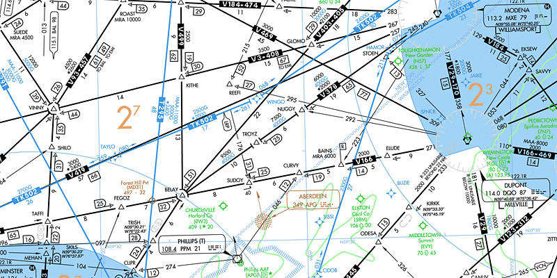
English: Examples of elements en:Instrument Flight Rules air navigation charts. We can see smaller airports in green (Churchville, Elkton), VOR stations as black hexagons (PPM, DQO, MXE), NDB station as brown spot (APG), VORNAV intersections, fixes as black triangles (FEGOZ, BELAY, SAVVY), RNAV fixes as blue stars (SISSI, BUZIE, WINGO), VORNAV airways in black (V166, V499), RNAV airways in blue (TK502, T295), minimum safe altitudes in brown (2700, 2300 ft MSL), approach areas (TMAs) in blue, holding patterns as grey ovals (TAFFI, TRISH, KIRKK), and other data. |
| Date | |
| Source | Derivative work from File:IFR_low_altitude_enroute_chart_Washington_D.C_area.tif |
| Author | Orion 8 |
Licensing
[edit]
This image or file is a work of a Federal Aviation Administration employee, taken or made as part of that person's official duties. As a work of the U.S. federal government, the image is in the public domain in the United States.
|
 |
File history
Click on a date/time to view the file as it appeared at that time.
| Date/Time | Thumbnail | Dimensions | User | Comment | |
|---|---|---|---|---|---|
| current | 16:02, 14 November 2013 | | 800 × 400 (109 KB) | Orion 8 (talk | contribs) | {{Information |Description ={{en|1=-}} |Source ={{own}} |Author =Orion 8 |Date = |Permission = |other_versions = }} |
You cannot overwrite this file.
File usage on Commons
The following page uses this file:
File usage on other wikis
The following other wikis use this file:
- Usage on hu.wikipedia.org
- Usage on pt.wikipedia.org