File:ISS012-E-23609 NASA Apolima strait between Upolu and Savai'i islands.jpg
Aller à la navigation
Aller à la recherche

Taille de cet aperçu : 800 × 531 pixels. Autres résolutions : 320 × 212 pixels | 640 × 424 pixels | 1 024 × 679 pixels | 1 280 × 849 pixels | 3 040 × 2 016 pixels.
Fichier d’origine (3 040 × 2 016 pixels, taille du fichier : 3,47 Mio, type MIME : image/jpeg)
Légendes
Légendes
Ajoutez en une ligne la description de ce que représente ce fichier
Description
[modifier]
| Description |
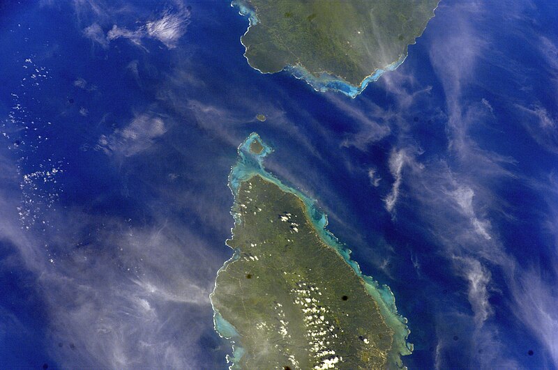
English: Satellite image of Upolu & Savai'i islands with Manono and Apolima in the Apolima Strait. |
| Date | |
| Source | Image Science and Analysis Laboratory, NASA-Johnson Space Center. "The Gateway to Astronaut Photography of Earth." <http://eol.jsc.nasa.gov/scripts/sseop/QuickView.pl?directory=ESC&ID=ISS012-E-23609> |
| Auteur |
NASA
|
| Autorisation (Réutilisation de ce fichier) |
Public Domain |
| Lieu de la prise de vue | | Voir cet endroit et d’autres images sur : OpenStreetMap |
|---|
Conditions d’utilisation
[modifier]
"The Gateway to Astronaut Photography of Earth". Image provenant du Laboratoire d'Analyse et d'Imagerie des Sciences, Centre Spatial Johnson de la NASA.
Source de la photo : ISS012-E-23609.
|
Historique du fichier
Cliquer sur une date et heure pour voir le fichier tel qu'il était à ce moment-là.
| Date et heure | Vignette | Dimensions | Utilisateur | Commentaire | |
|---|---|---|---|---|---|
| actuel | 19 mai 2013 à 16:34 | | 3 040 × 2 016 (3,47 Mio) | Ras67 (d | contributions) | colors adapted to the first one |
| 18 mai 2013 à 16:03 |  | 3 040 × 2 016 (3,48 Mio) | Ras67 (d | contributions) | new rendered from NASA's raw image data | |
| 30 janvier 2010 à 15:14 |  | 639 × 435 (60 kio) | Teinesavaii (d | contributions) | {{Information |Description={{en|1=Satellite image of Upolu & Savai'i islands with Manono and Apolima in the Apolima Strait.}} |Source=Image Science and Analysis Laboratory, NASA-Johnson Space Center. "The Gateway to Astronaut Photography of Earth." <htt |
Vous ne pouvez pas remplacer ce fichier.
Utilisations locales du fichier
Aucune page n’utilise ce fichier.
Utilisations du fichier sur d’autres wikis
Les autres wikis suivants utilisent ce fichier :
- Utilisation sur en.wikipedia.org
- Utilisation sur en.wikisource.org
- Utilisation sur fa.wikipedia.org
- Utilisation sur fr.wikipedia.org
- Utilisation sur mk.wikipedia.org
- Utilisation sur sm.wikipedia.org