File:Iberia 300BC-en.svg
پرش به ناوبری
پرش به جستجو

حجم پیشنمایش PNG این SVG file:۷۲۷ × ۶۰۰ پیکسل کیفیتهای دیگر: ۲۹۱ × ۲۴۰ پیکسل | ۵۸۲ × ۴۸۰ پیکسل | ۹۳۱ × ۷۶۸ پیکسل | ۱٬۲۴۲ × ۱٬۰۲۴ پیکسل | ۲٬۴۸۴ × ۲٬۰۴۸ پیکسل | ۹۲۴ × ۷۶۲ پیکسل.
پروندهٔ اصلی (پروندهٔ اسویجی، با ابعاد ۹۲۴ × ۷۶۲ پیکسل، اندازهٔ پرونده: ۷۷۲ کیلوبایت)
گزینهها
عنوان
شرحی یکخطی از محتوای این فایل اضافه کنید
خلاصه[ویرایش]

|
این پروندهٔ اسویجی از متن جاسازیشده استفاده میکند که بهسادگی میتوان با این ابزار خودکار آن را به زبانتان ترجمه کرد (اطلاعات بیشتر).
همچنین میتوانید تصویر را دریافت و با یک ویرایشگر متن به طور دستی آن را ویرایش کنید. |
| توضیح |
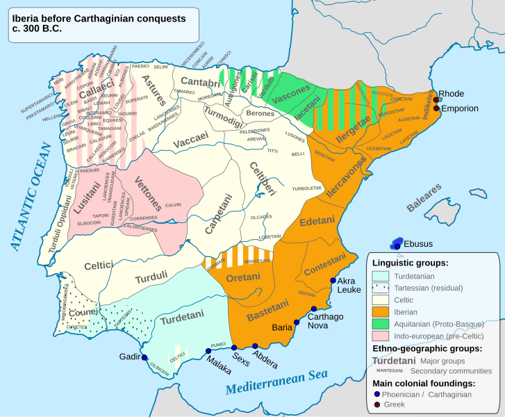
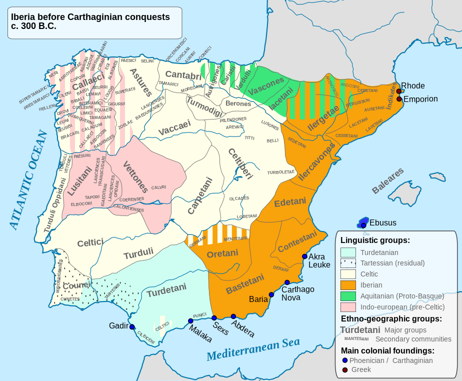
English: Ethnographic and Linguistic Map of the Iberian Peninsula at about 300 BCE (before the Carthaginian conquests). |
||
| تاریخ | |||
| منبع |
Based on the map done by Portuguese Archeologist Luís Fraga, from the "Campo Arqueológico de Tavira". The reference map can be found at this location [1]. Original source: https://web.archive.org/web/20161105032508/http://geohistorica.net/arkeotavira.com/Mapas/Iberia/Populi.pdf |
||
| پدیدآور | Alcides Pinto | ||
| اجازهنامه (استفادهٔ مجدد از این پرونده) |
من، صاحب حقوق قانونی این اثر، به این وسیله این اثر را تحث اجازهنامهٔ ذیل منتشر میکنم:
|
||
| دیگر نسخهها |
آثار انشقاقی از این پرونده: Ethnographic Iberia 200 BCE.PNG Languages of pre-Roman Iberia.jpg |

تاریخچهٔ پرونده
روی تاریخ/زمانها کلیک کنید تا نسخهٔ مربوط به آن هنگام را ببینید.
| تاریخ/زمان | بندانگشتی | ابعاد | کاربر | توضیح | |
|---|---|---|---|---|---|
| کنونی | ۲۷ اکتبر ۲۰۲۳، ساعت ۱۵:۴۱ | | ۹۲۴ در ۷۶۲ (۷۷۲ کیلوبایت) | Il Qathar (بحث | مشارکتها) | Reverted to version as of 20:39, 10 August 2012 (UTC) (the most recent upload messed the captions, which are gone). |
| ۷ ژوئن ۲۰۲۲، ساعت ۲۰:۲۵ |  | ۹۲۴ در ۷۶۲ (۷۱۱ کیلوبایت) | Coralma* (بحث | مشارکتها) | File uploaded using svgtranslate tool (https://svgtranslate.toolforge.org/). Added translation for nl-informal. | |
| ۱۰ اوت ۲۰۱۲، ساعت ۲۰:۳۹ |  | ۹۲۴ در ۷۶۲ (۷۷۲ کیلوبایت) | Galazan (بحث | مشارکتها) | More precise localization of: Indiketes, Ausetani, Layetani, Ilergetae, Ceretani and Andosini | |
| ۸ آوریل ۲۰۱۲، ساعت ۱۵:۴۵ |  | ۹۲۴ در ۷۶۲ (۸۰۵ کیلوبایت) | Kordas (بحث | مشارکتها) | Fixing Formentera color and showing mixed area in Oretania | |
| ۸ آوریل ۲۰۱۲، ساعت ۰۳:۴۲ |  | ۹۲۴ در ۷۶۲ (۴۹۰ کیلوبایت) | Kordas (بحث | مشارکتها) | See file talk | |
| ۲۶ آوریل ۲۰۱۰، ساعت ۲۳:۰۳ |  | ۹۲۴ در ۷۶۲ (۳۲۶ کیلوبایت) | Alcides Pinto (بحث | مشارکتها) | Solve upload problem | |
| ۲۶ آوریل ۲۰۱۰، ساعت ۲۲:۵۴ |  | ۹۲۴ در ۷۶۲ (۳۲۶ کیلوبایت) | Alcides Pinto (بحث | مشارکتها) | {{Information |Description={{en|1=Ethnographic and Linguistic Map of the Iberian Peninsula at about 300 BCE (before the Carthaginian conquests).}} |Source=Based on the map done by Portuguese Archeologist Luís Fraga, from the "Campo Arqueológico de Tavir |
شما نمیتوانید این پرونده را رونویسی کنید.
کاربرد پرونده
صفحههای زیر از این تصویر استفاده میکنند:
- Celts
- User:Magog the Ogre/Multilingual legend/2022 June 1-10
- User:Magog the Ogre/Multilingual legend/2023 October 27-31
- File:Ethnographic Iberia 200 BCE-it.PNG
- File:Ethnographic Iberia 200 BCE.PNG
- File:Etnographic Iberia 200 BCE-hu.png
- File:Iberia 300BC-fr.svg
- File:Iberia 300BC-pt.svg
- File:Iberia 300BC.svg (تغییرمسیر پرونده)
- File:Ibèria el 300 aC.svg
- File:Prehispanic languages.gif
- File:Turdetani locator map.svg
کاربرد سراسری پرونده
ویکیهای دیگر زیر از این پرونده استفاده میکنند:
- کاربرد در ace.wikipedia.org
- کاربرد در an.wikipedia.org
- کاربرد در ast.wikipedia.org
- کاربرد در be.wikipedia.org
- کاربرد در bg.wikipedia.org
- کاربرد در br.wikipedia.org
- کاربرد در ca.wikipedia.org
- کاربرد در da.wikipedia.org
- کاربرد در de.wikipedia.org
- Eisenzeit
- Spanische Sprache
- Baskische Sprache
- Iberer
- Keltiberer
- 194 v. Chr.
- Lusitaner
- Geschichte Karthagos
- Keltiberische Sprache
- Keltische Nationen
- Sprachen auf der Iberischen Halbinsel
- Kantabrer
- Benutzer Diskussion:Roxanna/Arbeitsplatz
- Liste antiker Ethnien der Iberischen Halbinsel
- Vettonen
- Turdetaner
- Carpetani
- Edetani
- Benutzer:JEW/Nekropole von El Cascarujo
- کاربرد در el.wikipedia.org
- کاربرد در en.wikipedia.org
نمایش استفادههای سراسری از این پرونده.
فراداده
ردهها:
- Maps of archaeological sites in Spain
- Maps of Pre-Roman Iberia
- Maps of the Iberian Celts
- Iberians
- Tartessos
- English-language SVG maps of Europe
- 300 BC
- Maps of 4th-century BC Europe
- Spain in the 4th century BC
- Portugal in the 4th century BC
- Aquitani
- Celtic peoples of the Iberian Peninsula
- Lusitanians
- Maps of Gallaecia
- Olcades