File:Ice Swirls in Labrador Sea (MODIS 2019-05-21).jpg
Jump to navigation
Jump to search
Size of this preview: 761 × 599 pixels. Other resolutions: 305 × 240 pixels | 610 × 480 pixels | 975 × 768 pixels | 1,280 × 1,008 pixels | 2,560 × 2,016 pixels | 2,674 × 2,106 pixels.
Original file (2,674 × 2,106 pixels, file size: 2.77 MB, MIME type: image/jpeg)
Captions
Captions
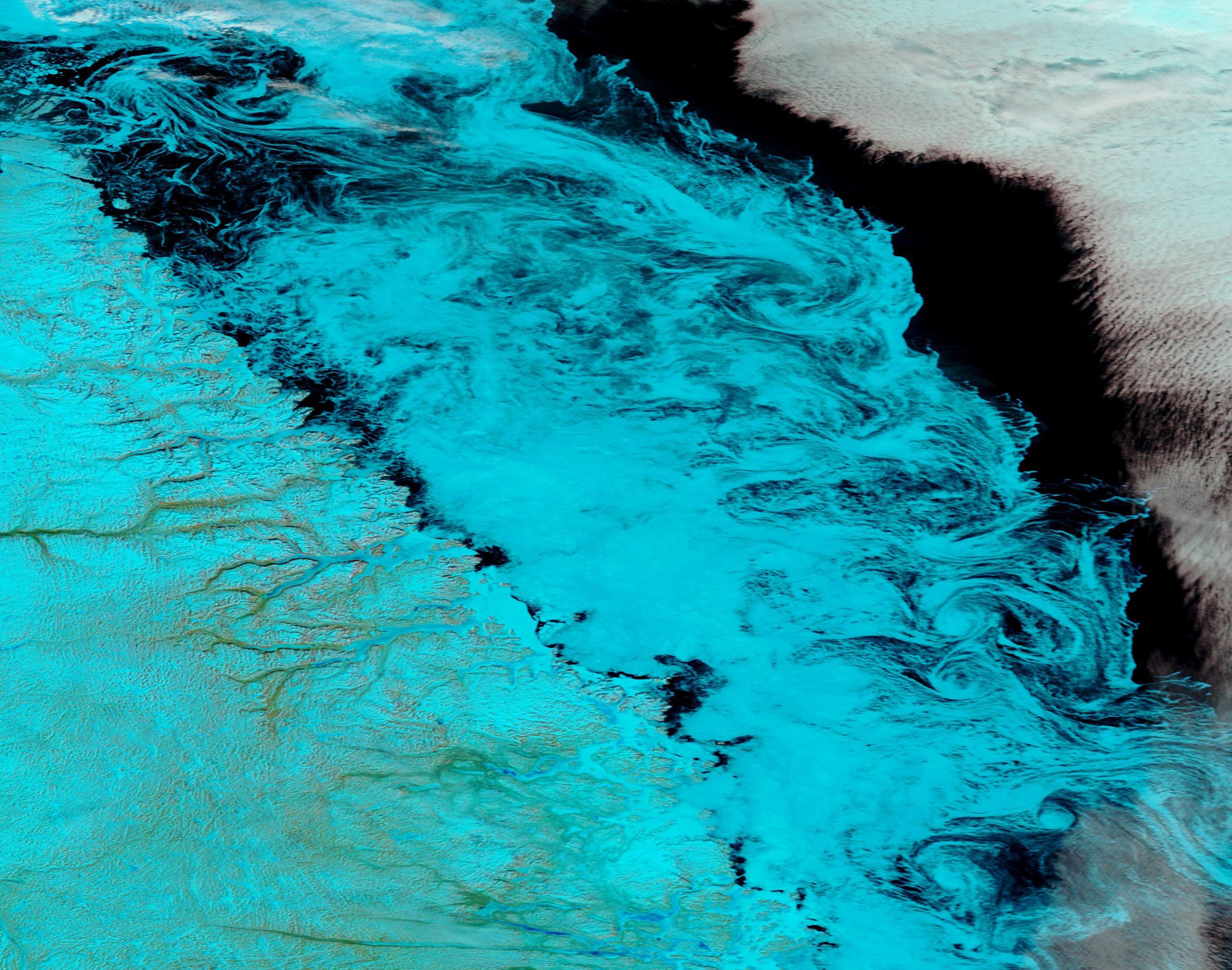
On May 16, 2091, the Moderate Resolution Imaging Spectroradiometer (MODIS) on board NASA’s Aqua satellite acquired a beautiful false-color image of swirls of thinning sea ice in the Labrador Sea off of Newfoundland and Labrador, Canada.
Summary
[edit].jpg&action=edit§ion=1)
| Description |
English: Spring brings lengthening daylight and warming temperatures, spurring the melting of sea ice across the Arctic. On May 16, 2091, the Moderate Resolution Imaging Spectroradiometer (MODIS) on board NASA’s Aqua satellite acquired a beautiful false-color image of swirls of thinning sea ice in the Labrador Sea off of Newfoundland and Labrador, Canada.
In the height of winter, sea ice reaches maximum thickness. Thick ice becomes rigid. While thick ice may cling to the shore as fast ice or be broken into large chunks as it floats on a moving ocean, only thinner, more flexible ice can be swirled into filigrees and swirls. The ice in this image has begun to melt, allowing currents and winds to spin it into beautiful designs. False-color imagery uses data from various bands on the MODIS instrument to highlight features that might not otherwise be easy to see. This image uses a combination of infrared and visible light (bands 7,2,1) to discern snow and ice from cloud. In a true-color image, snow, ice, and cloud would all appear white. In this image, however, both snow and ice appear electric blue, while cloud appears white. Deep water appears black and non-vegetated land appears tan. |
||
| Date | Taken on 16 May 2019 | ||
| Source |
Ice Swirls in Labrador Sea (direct link)
|
||
| Author | MODIS Land Rapid Response Team, NASA GSFC |
| This media is a product of the Aqua mission Credit and attribution belongs to the mission team, if not already specified in the "author" row |
Licensing
[edit].jpg&action=edit§ion=2)
| This file is in the public domain in the United States because it was solely created by NASA. NASA copyright policy states that "NASA material is not protected by copyright unless noted". (See Template:PD-USGov, NASA copyright policy page or JPL Image Use Policy.) | ||
 |
Warnings:
|
File history
Click on a date/time to view the file as it appeared at that time.
| Date/Time | Thumbnail | Dimensions | User | Comment | |
|---|---|---|---|---|---|
| current | 03:20, 17 February 2024 | | 2,674 × 2,106 (2.77 MB) | OptimusPrimeBot (talk | contribs) | #Spacemedia - Upload of http://modis.gsfc.nasa.gov/gallery/images/image05212019_250m.jpg via Commons:Spacemedia |
You cannot overwrite this file.
File usage on Commons
There are no pages that use this file.
.jpg&oldid=852756253)