File:Ice in Strait of Tartary, Russia (MODIS 2019-01-17).jpg
Jump to navigation
Jump to search

Size of this preview: 800 × 584 pixels. Other resolutions: 320 × 234 pixels | 640 × 468 pixels | 1,024 × 748 pixels | 1,280 × 935 pixels | 2,423 × 1,770 pixels.
Original file (2,423 × 1,770 pixels, file size: 886 KB, MIME type: image/jpeg)
Captions
Captions
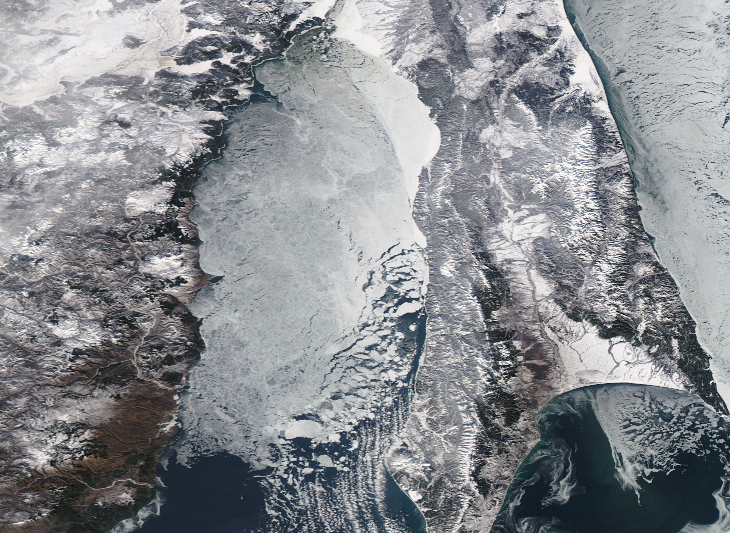
On January 13, 2019, the Moderate Resolution Imaging Spectroradiometer (MODIS) on board NASA’s Aqua satellite acquired a true-color image of ice in the Strait of Tartary.
Summary
[edit].jpg&action=edit§ion=1)
| Description |
English: The Strait of Tartary separates mainland Russia from its largest island, Sakhalin Island. The narrow strait—which constricts to only 4.5 mi (7.3 km) wide—connects the Sea of Okhotsk in the north with the Sea of Japan to the south. Although it theoretically is the shortest shipping route between the southern coast of Russia to the northern coast, most commercial ships travel longer routes rather than pass through the Strait, likely because the very shallow depth (13-66 feet/4-20 meters) makes travel only practical for lightly loaded or smaller vessels. In the winter, the Strait freezes early, which also precludes shipping for nearly half the year.
On January 13, 2019, the Moderate Resolution Imaging Spectroradiometer (MODIS) on board NASA’s Aqua satellite acquired a true-color image of ice in the Strait of Tartary. The image focuses on heavy ice in the southern section of the Strait, where the waters are relatively wide. The Strait can be need to begin to sharply narrow at the top edge of the image. |
||
| Date | Taken on 13 January 2019 | ||
| Source |
Ice in Strait of Tartary, Russia (direct link)
|
||
| Author | MODIS Land Rapid Response Team, NASA GSFC |
| This media is a product of the Aqua mission Credit and attribution belongs to the mission team, if not already specified in the "author" row |
Licensing
[edit].jpg&action=edit§ion=2)
| This file is in the public domain in the United States because it was solely created by NASA. NASA copyright policy states that "NASA material is not protected by copyright unless noted". (See Template:PD-USGov, NASA copyright policy page or JPL Image Use Policy.) | ||
 |
Warnings:
|
File history
Click on a date/time to view the file as it appeared at that time.
| Date/Time | Thumbnail | Dimensions | User | Comment | |
|---|---|---|---|---|---|
| current | 03:34, 17 February 2024 | | 2,423 × 1,770 (886 KB) | OptimusPrimeBot (talk | contribs) | #Spacemedia - Upload of http://modis.gsfc.nasa.gov/gallery/images/image01172019_250m.jpg via Commons:Spacemedia |
You cannot overwrite this file.
File usage on Commons
There are no pages that use this file.
.jpg&oldid=852758027)