File:Iceland-Route-52.png
Jump to navigation
Jump to search
Size of this preview: 800 × 546 pixels. Other resolutions: 320 × 218 pixels | 640 × 437 pixels | 1,059 × 723 pixels.
Original file (1,059 × 723 pixels, file size: 193 KB, MIME type: image/png)
Captions
Captions
Add a one-line explanation of what this file represents
Summary[edit]
| Description |
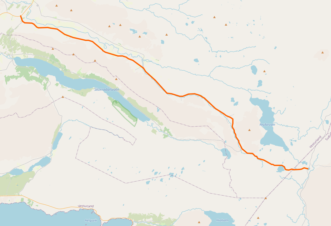
Deutsch: Der Verlauf der Straße 52 in Island. Die Karte wurde aus OpenStreetMap kopiert mit den dort gesammelten Daten der Gemeinschaft. Dieser Kartenausschnitt kann unvollständig und fehlerhaft sein. |
| Date | |
| Source | http://www.openstreetmap.org/ |
| Author | OpenStreetMap contributors |
| Remarks | Deutsch: Nicht der aktuelle gesamte Verlauf, nur das westliche Stück |
Licensing[edit]
This file is licensed under the Creative Commons Attribution-Share Alike 4.0 International license.
- You are free:
- to share – to copy, distribute and transmit the work
- to remix – to adapt the work
- Under the following conditions:
- attribution – You must give appropriate credit, provide a link to the license, and indicate if changes were made. You may do so in any reasonable manner, but not in any way that suggests the licensor endorses you or your use.
- share alike – If you remix, transform, or build upon the material, you must distribute your contributions under the same or compatible license as the original.
Original upload log[edit]
Transferred from de.wikipedia to Commons by Wdwdbot using script bot_filetrans.pl (r112M).
The original description page was here. All following user names refer to de.wikipedia.
- 2020-07-16 08:46:36 Andreas-is (197210 Bytes) {{Information |Beschreibung = Der Verlauf der Straße 52 in Island. Die Karte wurde aus OpenStreetMap kopiert mit den dort gesammelten Daten der Gemeinschaft. Dieser Kartenausschnitt kann unvollständig und fehlerhaft sein. |Quelle = http://www.openstreetmap.org/ |Urheber = OpenStreetMap contributors |Datum = 14. Juli 2020 |Genehmigung = |Andere Versionen = |Anmerkungen = Nicht der aktuelle gesamte Verlauf, nur das westliche Stück }}
File history
Click on a date/time to view the file as it appeared at that time.
| Date/Time | Thumbnail | Dimensions | User | Comment | |
|---|---|---|---|---|---|
| current | 12:49, 17 July 2020 | | 1,059 × 723 (193 KB) | Wdwdbot (talk | contribs) | Bot Move: Original uploader of this revision (#1) was Andreas-is at de.wikipedia |
You cannot overwrite this file.
File usage on Commons
There are no pages that use this file.
File usage on other wikis
The following other wikis use this file:
- Usage on de.wikipedia.org