File:Ie defence positions.png
পরিভ্রমণে চলুন
অনুসন্ধানে চলুন

এই প্রাকদর্শনের আকার: ৮০০ × ৪৭৬ পিক্সেল। অন্যান্য আকারসমূহ: ৩২০ × ১৯০ পিক্সেল | ৬৪০ × ৩৮১ পিক্সেল | ১,২১৭ × ৭২৪ পিক্সেল।
মূল ফাইল (১,২১৭ × ৭২৪ পিক্সেল, ফাইলের আকার: ৮০৩ কিলোবাইট, এমআইএমই ধরন: image/png)
ক্যাপশনসমূহ
ক্যাপশন
এই ফাইল কি প্রতিনিধিত্ব করছে তার এক লাইন ব্যাখ্যা যোগ করুন
সারাংশ[সম্পাদনা]
| বিবরণ |
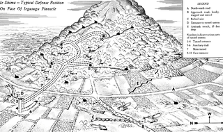
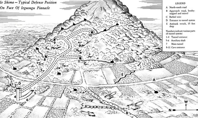
English: This diagram of a typical defense system on the face of Iegusugu Pinnacle was adapted from a sketch appearing in CINCPAC-CINCPOA Weekly Intelligence, Volume 2, Number 5, 13 August 1945. The diagram does not show all the defensive positions in the area depicted and is designed only to indicate the method by which the enemy attained mobility even in fighting from positions underground. In describing this position the bulletin states: About 50 yards south of the approach road was the camouflaged entrance to a typical tunnel system within the hill. The entrance was a square log-shored shaft 30 feet deep. A smaller curved shaft which came to the surface about 15 feet away was probably designed for ventilation purposes. The main tunnel to the hill installations ran from this shaft, under the road to the first of a series of caves approximately 100 feet from the shaft entrance. This tunnel was from four to five feet high and three feet wide. Walls were reinforced with logs six to eight inches in diameter, loose coral rock on the ceilings was held in place by logs. The tunnel apparently was used for ammunition storage as well as communication.
العربية: مُخطط عسكري أمريكي مرسوم للأنفاق والمنشآت الدفاعية اليابانية النموذجية في تلال جزيرة أوكيناوا |
| তারিখ | |
| উৎস | www.army.mil |
| লেখক | United States Army (Post-Work: User:W.wolny) |
| অনুমতি (এ ফাইলের পুনঃব্যবহার) |
Public Domain |
লাইসেন্স প্রদান[সম্পাদনা]
এই চিত্রটি মার্কিন সেনাবাহিনীর একজন সৈনিক বা কর্মীর একটি কর্ম, যা তিনি তার অফিসিয়াল কর্তব্যের অংশ হিসেবে তুলেছেন বা সৃষ্টি করেছেন। মার্কিন যুক্তরাষ্ট্রের ফেডারেল সরকারের একটি কর্ম হিসেবে, এই চিত্রটি পাবলিক ডোমেইনভুক্ত।
|
 |
ফাইলের ইতিহাস
যেকোনো তারিখ/সময়ে ক্লিক করে দেখুন ফাইলটি তখন কী অবস্থায় ছিল।
| তারিখ/সময় | সংক্ষেপচিত্র | মাত্রা | ব্যবহারকারী | মন্তব্য | |
|---|---|---|---|---|---|
| বর্তমান | ২২:০৫, ২৫ সেপ্টেম্বর ২০১৬ | | ১,২১৭ × ৭২৪ (৮০৩ কিলোবাইট) | Cmdrjameson (আলোচনা | অবদান) | Compressed with pngout. Reduced by 357kB (30% decrease). |
| ১৭:২৮, ২২ জুন ২০০৫ |  | ১,২১৭ × ৭২৪ (১.১৩ মেগাবাইট) | W.wolny (আলোচনা | অবদান) |
আপনি এই ফাইলটি প্রতিস্থাপন করতে পারবেন না।
ফাইলের ব্যবহার
নিম্নলিখিত পাতাটি এই ফাইল ব্যবহার করে:
ফাইলের বৈশ্বিক ব্যবহার
নিচের অন্যান্য উইকিগুলো এই ফাইলটি ব্যবহার করে:
- ar.wikipedia.org-এ ব্যবহার
- azb.wikipedia.org-এ ব্যবহার
- bg.wikipedia.org-এ ব্যবহার
- bn.wikipedia.org-এ ব্যবহার
- br.wikipedia.org-এ ব্যবহার
- en.wikipedia.org-এ ব্যবহার
- eu.wikipedia.org-এ ব্যবহার
- fr.wikipedia.org-এ ব্যবহার
- ja.wikipedia.org-এ ব্যবহার
- ms.wikipedia.org-এ ব্যবহার
- no.wikipedia.org-এ ব্যবহার
- sv.wikipedia.org-এ ব্যবহার
- th.wikipedia.org-এ ব্যবহার
- tr.wikipedia.org-এ ব্যবহার