File:Ile de l'ascension routes-de.svg
Jump to navigation
Jump to search

Size of this PNG preview of this SVG file: 800 × 573 pixels. Other resolutions: 320 × 229 pixels | 640 × 459 pixels | 1,024 × 734 pixels | 1,280 × 917 pixels | 2,560 × 1,834 pixels | 1,051 × 753 pixels.
Original file (SVG file, nominally 1,051 × 753 pixels, file size: 224 KB)
Captions
Captions
Add a one-line explanation of what this file represents
Summary
[edit]| Description |
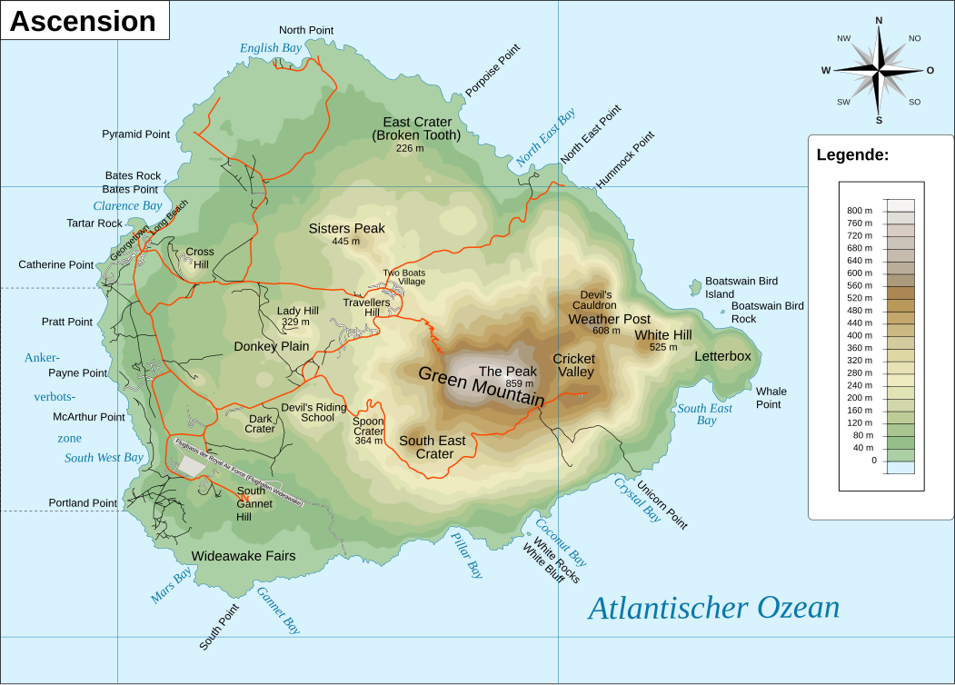
Deutsch: Karte der Insel Ascension mit Wegenetz.
Français : Carte presque vierge de l'Île de l'Ascension. |
||
| Date | |||
| Source | |||
| Author |
|
||
| Permission (Reusing this file) |
I, the copyright holder of this work, hereby publish it under the following licenses:
This file is licensed under the Creative Commons Attribution-Share Alike 4.0 International license.
You may select the license of your choice. |
||
| Other versions |
|
||
| SVG development | This map was created with Adobe Illustrator. |


File history
Click on a date/time to view the file as it appeared at that time.
| Date/Time | Thumbnail | Dimensions | User | Comment | |
|---|---|---|---|---|---|
| current | 13:36, 6 June 2021 | | 1,051 × 753 (224 KB) | Furfur (talk | contribs) | typos |
| 13:55, 5 June 2021 |  | 1,051 × 753 (224 KB) | Furfur (talk | contribs) | typo | |
| 13:24, 5 June 2021 |  | 1,051 × 753 (224 KB) | Furfur (talk | contribs) | == {{int:filedesc}} == {{Information |Description={{User:Medium69/Traduction}} {{de|1=Karte der Insel Ascension mit Wegenetz.}} {{fr|1=Carte presque vierge de l'Île de l'Ascension.}} |Source=*Ile_de_l'ascension.svg * [http://www.openstreetmap.org/index.html?mlat=-7.9333&mlon=-14.3666&zoom=17&layers=M Map for free] |Date=2010-10-12 18:57 (UTC) |Author=*Ile_de_l'ascension.svg: [[User:T... |
You cannot overwrite this file.
File usage on Commons
The following page uses this file:
File usage on other wikis
The following other wikis use this file:
- Usage on de.wikipedia.org