File:Imperium Romanum Germania.png
ნავიგაციაზე გადასვლა
ძიებაზე გადასვლა
უფრო მაღალი გარჩევადობა არ არის შესაძლებელი.
Imperium_Romanum_Germania.png (700 × 491 პიქსელი, ფაილის ზომა: 203 კბ, MIME ტიპი: image/png)
Captions
Captions
Add a one-line explanation of what this file represents
რეზიუმე
[რედაქტირება]| აღწერა |
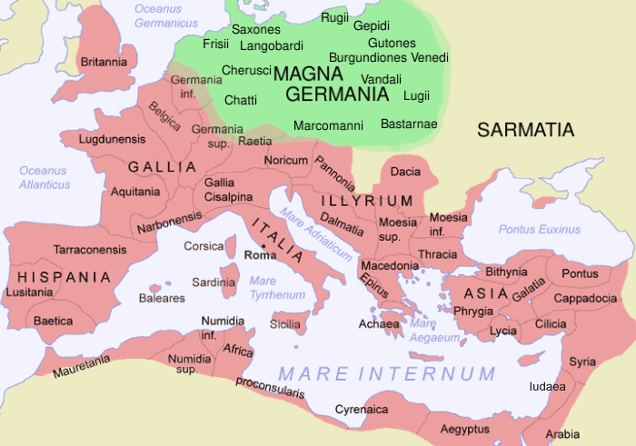
English: The Roman Empire in 116 AD and Germania Magna, with some Germanic tribes mentioned by Tacitus in CE 98 (quick sketch, could be updated with greater accuracy).
Deutsch: Das Römische Reich 116 n. Chr. und Germania Magna, mit einigen germanischen Stämmen, die von Tacitus im Jahr 98 erwähnt werden (schnelle Skizze, könnte noch mit größerer Präzision weiterbearbeitet werden).
Español: El Imperio Romano en 116 d.C. y Germania Magna, con algunas tribus germanas mencionadas por Tácito en 98 d.C. (bosquejo, debe actualizarse con mayor precisión).
Esperanto: La Romia Imperio dum la jaro 116 kaj Germania Magna, kun iuj ĝermanaj triboj menciitaj de Tacitus dum la jaro 98 (rapida skizo, povus esti pliprilaborita kun pli da precizeco).
کوردی: وێنەی ئیمپراتۆری ڕۆم و ئاڵمانیای گەورە لە ساڵی 1١١٦ زاییندا، ئەم وێنە ناوی هەندێک لە هۆزە ئاڵمایاییەکانیشی تێدایە. |
||||||||
| წყარო | File:Romia Imperio.png, originally by Jani Niemenmaa/ThomasPusch. | ||||||||
| ავტორი | Modification · Bearbeitung · Prilaboro: D. Bachmann | ||||||||
| უფლება (ფაილის მეორეული გამოყენება) |
|
||||||||
| სხვა ვერსიები | العربيَّة |

ფაილის ისტორია
დააწკაპუნეთ თარიღზე/დროზე, რათა იხილოთ ფაილი, როგორც ის მაშინ გამოიყურებოდა.
| თარიღი/დრო | მინიატიურა | განზომილებები | მომხმარებელი | კომენტარი | |
|---|---|---|---|---|---|
| მიმდინარე | 14:17, 22 ნოემბერი 2021 | | 700 × 491 (203 კბ) | Claude Zygiel (განხილვა | წვლილი) | More precise |
| 14:32, 4 თებერვალი 2012 |  | 700 × 491 (188 კბ) | AnonMoos (განხილვა | წვლილი) | changing anachronistic label "Palestina"[sic] to "Iudaea" -- term "Palaestina" did not come into official use until ca. 135 AD | |
| 12:07, 29 დეკემბერი 2009 |  | 700 × 491 (192 კბ) | Olahus (განხილვა | წვლილი) | m | |
| 05:46, 20 ივნისი 2007 |  | 700 × 491 (193 კბ) | ThomasPusch (განხილვა | წვლილი) | Tarragonensis corrected/berichtigt/korektita | |
| 11:57, 16 ივნისი 2007 |  | 700 × 491 (196 კბ) | ThomasPusch (განხილვა | წვლილი) | ''Achaia'' to ''Achaea'' | |
| 21:57, 22 დეკემბერი 2006 |  | 700 × 491 (210 კბ) | Electionworld (განხილვა | წვლილი) | {{ew|en|Dbachmann}} == Summary == The Roman Empire in CE 120 and Germania, with some Germanic tribes mentioned by Tacitus in CE 98 (quick sketch, should be updated with greater precision). Based on Image:Roman Empire Map.png by Jani Niemenmaa == Li |
თქვენ არ შეგიძლიათ ამ ფაილზე გადაწერა.
ფაილის გამოყენება
მომდევნო გვერდები იყენებენ ამ ფაილს:
ფაილის გლობალური გამოყენება
ეს ფაილი გამოიყენება შემდეგ ვიკებში:
- გამოყენება ar.wikipedia.org-ში
- გამოყენება ast.wikipedia.org-ში
- გამოყენება av.wikipedia.org-ში
- გამოყენება azb.wikipedia.org-ში
- გამოყენება bg.wikipedia.org-ში
- გამოყენება br.wikipedia.org-ში
- გამოყენება bs.wikipedia.org-ში
- გამოყენება ca.wikipedia.org-ში
- გამოყენება ckb.wikipedia.org-ში
- გამოყენება cs.wikipedia.org-ში
- გამოყენება cy.wikipedia.org-ში
- გამოყენება da.wikipedia.org-ში
- გამოყენება de.wikipedia.org-ში
- გამოყენება el.wikipedia.org-ში
- გამოყენება en.wikipedia.org-ში
- გამოყენება en.wiktionary.org-ში
- გამოყენება eo.wikipedia.org-ში
- გამოყენება es.wikipedia.org-ში
იხილეთ, ამ ფაილის გლობალური გამოყენება.
მეტამონაცემები
კატეგორიები:
- Locator maps of provinces of the Roman Empire (pink scheme)
- Maps of the Roman Empire in 116 AD
- Germany in the 3rd century
- Germany in the 2nd century
- Germany in the 1st century
- Mecklenburg-Vorpommern in the 3rd century
- Mecklenburg-Vorpommern in the 2nd century
- Mecklenburg-Vorpommern in the 1st century
- Poland in the 1st century
- Poland in the 2nd century
- Poland in the 3rd century
- Slovakia in the 1st century
- Slovakia in the 2nd century
- Slovakia in the 3rd century
- Bohemia in the 1st century
- Bohemia in the 2nd century
- Bohemia in the 3rd century
- Ancient Germanic peoples
- Maps of Germania magna
- Maps of 2nd-century Europe