File:Imperium Romanum Germania.png
Pāriet uz navigāciju
Pāriet uz meklēšanu
Augstāka izšķirtspēja nav pieejama.
Imperium_Romanum_Germania.png (700 × 491 pikseļi, faila izmērs: 203 KB, MIME tips: image/png)
Captions
Captions
Pievieno vienas rindiņas aprakstu, ko šis fails attēlo
Kopsavilkums[labot šo sadaļu]
| Apraksts |
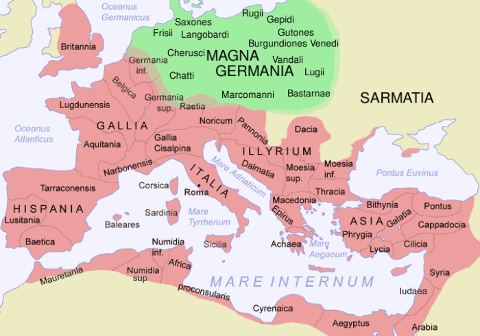
English: The Roman Empire in 116 AD and Germania Magna, with some Germanic tribes mentioned by Tacitus in CE 98 (quick sketch, could be updated with greater accuracy).
Deutsch: Das Römische Reich 116 n. Chr. und Germania Magna, mit einigen germanischen Stämmen, die von Tacitus im Jahr 98 erwähnt werden (schnelle Skizze, könnte noch mit größerer Präzision weiterbearbeitet werden).
Español: El Imperio Romano en 116 d.C. y Germania Magna, con algunas tribus germanas mencionadas por Tácito en 98 d.C. (bosquejo, debe actualizarse con mayor precisión).
Esperanto: La Romia Imperio dum la jaro 116 kaj Germania Magna, kun iuj ĝermanaj triboj menciitaj de Tacitus dum la jaro 98 (rapida skizo, povus esti pliprilaborita kun pli da precizeco).
کوردی: وێنەی ئیمپراتۆری ڕۆم و ئاڵمانیای گەورە لە ساڵی 1١١٦ زاییندا، ئەم وێنە ناوی هەندێک لە هۆزە ئاڵمایاییەکانیشی تێدایە. |
||||||||
| Avots | File:Romia Imperio.png, originally by Jani Niemenmaa/ThomasPusch. | ||||||||
| Autors | Modification · Bearbeitung · Prilaboro: D. Bachmann | ||||||||
| Atļauja: (Šī faila izmantošana citur) |
|
||||||||
| Citas versijas | العربيَّة |

Faila hronoloģija
Uzklikšķini uz datums/laiks kolonnā esošās saites, lai apskatītos, kā šis fails izskatījās tad.
| Datums/Laiks | Attēls | Izmēri | Dalībnieks | Komentārs | |
|---|---|---|---|---|---|
| tagadējais | 2021. gada 22. novembris, plkst. 14.17 | | 700 × 491 (203 KB) | Claude Zygiel (diskusija | devums) | More precise |
| 2012. gada 4. februāris, plkst. 14.32 |  | 700 × 491 (188 KB) | AnonMoos (diskusija | devums) | changing anachronistic label "Palestina"[sic] to "Iudaea" -- term "Palaestina" did not come into official use until ca. 135 AD | |
| 2009. gada 29. decembris, plkst. 12.07 |  | 700 × 491 (192 KB) | Olahus (diskusija | devums) | m | |
| 2007. gada 20. jūnijs, plkst. 05.46 |  | 700 × 491 (193 KB) | ThomasPusch (diskusija | devums) | Tarragonensis corrected/berichtigt/korektita | |
| 2007. gada 16. jūnijs, plkst. 11.57 |  | 700 × 491 (196 KB) | ThomasPusch (diskusija | devums) | ''Achaia'' to ''Achaea'' | |
| 2006. gada 22. decembris, plkst. 21.57 |  | 700 × 491 (210 KB) | Electionworld (diskusija | devums) | {{ew|en|Dbachmann}} == Summary == The Roman Empire in CE 120 and Germania, with some Germanic tribes mentioned by Tacitus in CE 98 (quick sketch, should be updated with greater precision). Based on Image:Roman Empire Map.png by Jani Niemenmaa == Li |
Šo failu nevar pārrakstīt.
Faila lietojums
Šo failu izmanto šajās 5 lapās:
Globālais faila lietojums
Šīs Vikipēdijas izmanto šo failu:
- Izmantojums ar.wikipedia.org
- Izmantojums ast.wikipedia.org
- Izmantojums av.wikipedia.org
- Izmantojums azb.wikipedia.org
- Izmantojums bg.wikipedia.org
- Izmantojums br.wikipedia.org
- Izmantojums bs.wikipedia.org
- Izmantojums ca.wikipedia.org
- Izmantojums ckb.wikipedia.org
- Izmantojums cs.wikipedia.org
- Izmantojums cy.wikipedia.org
- Izmantojums da.wikipedia.org
- Izmantojums de.wikipedia.org
- Izmantojums el.wikipedia.org
- Izmantojums en.wikipedia.org
- Izmantojums en.wiktionary.org
- Izmantojums eo.wikipedia.org
- Izmantojums es.wikipedia.org
- Izmantojums es.wiktionary.org
Skatīt šī faila pilno globālo izmantojumu.
Metadati
Kategorijas:
- Locator maps of provinces of the Roman Empire (pink scheme)
- Maps of the Roman Empire in 116 AD
- Germany in the 3rd century
- Germany in the 2nd century
- Germany in the 1st century
- Mecklenburg-Vorpommern in the 3rd century
- Mecklenburg-Vorpommern in the 2nd century
- Mecklenburg-Vorpommern in the 1st century
- Poland in the 1st century
- Poland in the 2nd century
- Poland in the 3rd century
- Slovakia in the 1st century
- Slovakia in the 2nd century
- Slovakia in the 3rd century
- Bohemia in the 1st century
- Bohemia in the 2nd century
- Bohemia in the 3rd century
- Ancient Germanic peoples
- Maps of Germania magna
- Maps of 2nd century Europe