File:In Deep (16153202370).jpg
Jump to navigation
Jump to search

Size of this preview: 800 × 535 pixels. Other resolutions: 320 × 214 pixels | 640 × 428 pixels | 1,024 × 685 pixels | 1,280 × 856 pixels | 2,560 × 1,712 pixels | 3,483 × 2,329 pixels.
Original file (3,483 × 2,329 pixels, file size: 7.72 MB, MIME type: image/jpeg)
Captions
Captions
Add a one-line explanation of what this file represents
Summary
[edit].jpg&action=edit§ion=1)
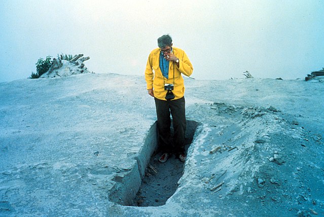
| Description | In Deep — In the aftermath of the May 1980 eruption of Mount St. Helens in Washington State, we find our #TBT for this week. Here, a geologist is standing in a trench of ash on Coldwater Ridge—about 18 inches deep. No reason, however, as to why the trench appears to be the same length as the height of the geologist...we'll leave that one for you to figure out ;) |
| Date | |
| Source | In Deep |
| Author | U.S. Geological Survey from Reston, VA, USA |
Licensing
[edit].jpg&action=edit§ion=2)
| This file is made available under the Creative Commons CC0 1.0 Universal Public Domain Dedication. | |
| The person who associated a work with this deed has dedicated the work to the public domain by waiving all of their rights to the work worldwide under copyright law, including all related and neighboring rights, to the extent allowed by law. You can copy, modify, distribute and perform the work, even for commercial purposes, all without asking permission.
|
| This image was originally posted to Flickr by U.S. Geological Survey at https://flickr.com/photos/27784370@N05/16153202370 (archive). It was reviewed on 19 January 2018 by FlickreviewR 2 and was confirmed to be licensed under the terms of the cc-zero. |
This image is in the public domain in the United States because it only contains materials that originally came from the United States Geological Survey, an agency of the United States Department of the Interior. For more information, see the official USGS copyright policy.
|
File history
Click on a date/time to view the file as it appeared at that time.
| Date/Time | Thumbnail | Dimensions | User | Comment | |
|---|---|---|---|---|---|
| current | 20:59, 19 January 2018 | | 3,483 × 2,329 (7.72 MB) | Artix Kreiger 2 (talk | contribs) | Transferred from Flickr via Flickr2Commons |
You cannot overwrite this file.
File usage on Commons
There are no pages that use this file.
File usage on other wikis
The following other wikis use this file:
- Usage on cs.wikipedia.org
.jpg&oldid=885859597)