File:Internal Structure of Marine Terrace.jpg
Jump to navigation
Jump to search

Size of this preview: 800 × 474 pixels. Other resolutions: 320 × 190 pixels | 640 × 379 pixels | 1,014 × 601 pixels.
Original file (1,014 × 601 pixels, file size: 143 KB, MIME type: image/jpeg)
Captions
Captions
Add a one-line explanation of what this file represents
Summary
[edit]
| Description |
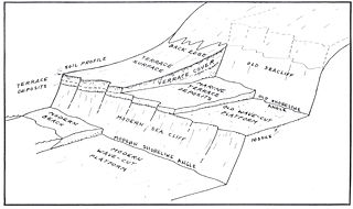
English: Schematic diagram of a marine terrace, indicating the relationship of the wave-cut platform to the shoreline angle and the overlying terrace deposits.
From: Weber, G. E., and A. O. Allwardt, 2001, Field Trip 1: The Geology from Santa Cruz to Point Año Nuevo—The San Gregorio Fault Zone and Pleistocene Marine Terraces. in. P. W. Stoffer and L. C. Gordon, eds., pp. 1-32, Geology and Natural History of the San Francisco Bay Area: A Field-Trip Guidebook 2001 Fall Field Conference National Association of Geoscience Teachers Far Western Section September 14–16, 2001 Menlo Park, California. Bulletin no. 2188. U.S. Geological Survey, Reston, Virginia. Figure 1.4, page 23. |
| Date | |
| Source | United States Geological Survey Bulletin no. 2188. https://pubs.usgs.gov/bul/b2188/b2188.pdf |
| Author | G. E. Weber and A. O. Allwardt, |
Licensing
[edit]
This image is in the public domain in the United States because it only contains materials that originally came from the United States Geological Survey, an agency of the United States Department of the Interior. For more information, see the official USGS copyright policy.
|
File history
Click on a date/time to view the file as it appeared at that time.
| Date/Time | Thumbnail | Dimensions | User | Comment | |
|---|---|---|---|---|---|
| current | 03:05, 8 June 2011 | | 1,014 × 601 (143 KB) | Cristellaria (talk | contribs) |
You cannot overwrite this file.
File usage on Commons
There are no pages that use this file.