File:Iran-geographic map.svg
跳转到导航
跳转到搜索

此SVG文件的PNG预览的大小:695 × 600像素。 其他分辨率:278 × 240像素 | 556 × 480像素 | 890 × 768像素 | 1,187 × 1,024像素 | 2,373 × 2,048像素 | 3,013 × 2,600像素。
原始文件 (SVG文件,尺寸为3,013 × 2,600像素,文件大小:12.7 MB)
说明
说明
添加一行文字以描述该文件所表现的内容
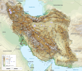
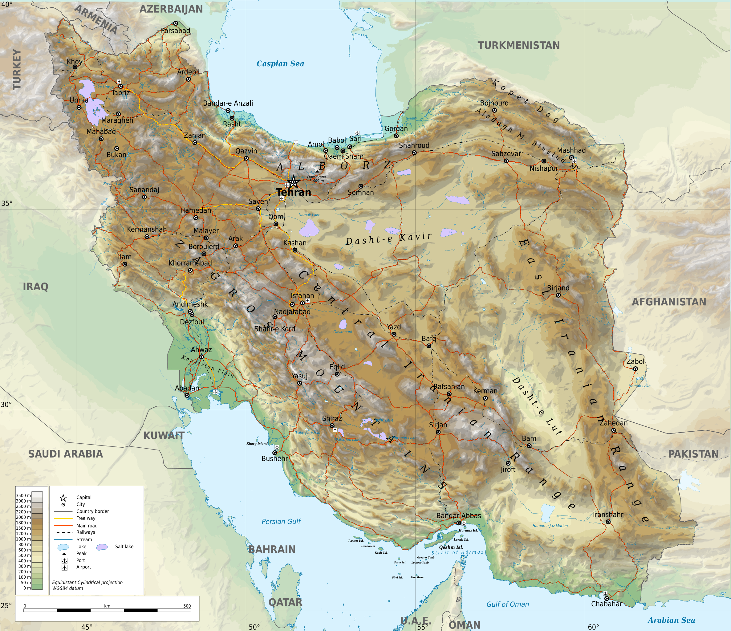
Geographic map of Iran
摘要[编辑]
| 描述 |
English: Geographic map of Iran. Limits of the map:
|
| 日期 | |
| 来源 |
自己的作品
|
| 作者 | Ikonact |
| 授权 (二次使用本文件) |
Any use of this map is subject of the license(s) stated below with the condition that you credit (Wikimedia Commons user: Ikonact) as the author . A message with a reply address would also be greatly appreciated. |
| SVG开发 |
许可协议[编辑]
| 此作品内含来自OpenStreetMap贡献者的地图资料,以开放数据库许可证(ODbL)释出。
对于从ODbL数据生成的地图,ODbL不需要任何特定许可。在2020年8月1日之前,OpenStreetMap基金会制作的地图图块已根据CC-BY-SA-2.0许可证授权。其他人制作的地图可能需要获得其他许可。 |
我,本作品著作权人,特此采用以下许可协议发表本作品:
本文件采用知识共享署名-相同方式共享 4.0 国际许可协议授权。
- 您可以自由地:
- 共享 – 复制、发行并传播本作品
- 修改 – 改编作品
- 惟须遵守下列条件:
- 署名 – 您必须对作品进行署名,提供授权条款的链接,并说明是否对原始内容进行了更改。您可以用任何合理的方式来署名,但不得以任何方式表明许可人认可您或您的使用。
- 相同方式共享 – 如果您再混合、转换或者基于本作品进行创作,您必须以与原先许可协议相同或相兼容的许可协议分发您贡献的作品。
评价[编辑]
文件历史
点击某个日期/时间查看对应时刻的文件。
| 日期/时间 | 缩略图 | 大小 | 用户 | 备注 | |
|---|---|---|---|---|---|
| 当前 | 2023年9月20日 (三) 21:45 | | 3,013 × 2,600(12.7 MB) | Socialdilema(留言 | 贡献) | File uploaded using svgtranslate tool (https://svgtranslate.toolforge.org/). Added translation for ca. |
| 2023年9月20日 (三) 17:25 |  | 3,013 × 2,600(12.69 MB) | Socialdilema(留言 | 贡献) | File uploaded using svgtranslate tool (https://svgtranslate.toolforge.org/). Added translation for ca. | |
| 2023年9月20日 (三) 17:22 |  | 3,013 × 2,600(12.68 MB) | Socialdilema(留言 | 贡献) | File uploaded using svgtranslate tool (https://svgtranslate.toolforge.org/). Added translation for ca. | |
| 2020年5月8日 (五) 14:08 |  | 3,013 × 2,600(12.62 MB) | Yamaha5(留言 | 贡献) | File uploaded using svgtranslate tool (https://tools.wmflabs.org/svgtranslate/). Added translation for fa. | |
| 2020年5月1日 (五) 20:44 |  | 3,013 × 2,600(12.62 MB) | Ikonact(留言 | 贡献) | + hidden Text: MW workaround for displaying translations | |
| 2020年5月1日 (五) 20:43 |  | 3,013 × 2,600(12.62 MB) | Ikonact(留言 | 贡献) | + hidden Text: MW workaround for displaying translations | |
| 2020年5月1日 (五) 20:39 |  | 3,013 × 2,600(12.62 MB) | Ikonact(留言 | 贡献) | File uploaded using svgtranslate tool (https://tools.wmflabs.org/svgtranslate/). Added translation for bg. | |
| 2020年5月1日 (五) 20:01 |  | 3,013 × 2,600(12.55 MB) | Ikonact(留言 | 贡献) | + hidden Text: MW workaround for displaying translations | |
| 2020年4月30日 (四) 21:49 |  | 3,013 × 2,600(12.55 MB) | Ahmad252(留言 | 贡献) | File uploaded using svgtranslate tool (https://tools.wmflabs.org/svgtranslate/). Added translation for fa. | |
| 2020年4月30日 (四) 21:10 |  | 3,013 × 2,600(13.24 MB) | Ikonact(留言 | 贡献) | + legend |
您不可以覆盖此文件。
文件用途
全域文件用途
以下其他wiki使用此文件:
- ar.wikipedia.org上的用途
- ast.wikipedia.org上的用途
- avk.wikipedia.org上的用途
- az.wikipedia.org上的用途
- bg.wikipedia.org上的用途
- bn.wikipedia.org上的用途
- ca.wikipedia.org上的用途
- ckb.wikipedia.org上的用途
- cs.wikipedia.org上的用途
- da.wikipedia.org上的用途
- diq.wikipedia.org上的用途
- el.wikipedia.org上的用途
- en.wikipedia.org上的用途
- eo.wikipedia.org上的用途
- eu.wikipedia.org上的用途
- fa.wikipedia.org上的用途
- جغرافیای ایران
- کاربر:Alieseraj
- توپوگرافی
- کاربر:مام وطن
- کاربر:Basp1
- کاربر:جعبه کاربر/مدافع خاک ایران
- کاربر:Gshahali
- بحث کاربر:Zzvf
- کاربر:Hamid Hassani
- کاربر:Derakhshan
- کاربر:Wiki center
- ویکیپدیا:گزیدن نگاره برگزیده/مه-۲۰۲۰
- کاربر:Arian.ramin
- ویکیپدیا:قهوهخانه/فنی/بایگانی ۶۵
- ویکیپدیا:گزیدن نگاره برگزیده/Iran-geographic map.svg
- کاربر:Adel2020
- ویکیپدیا:نگاره روز/اوت ۲۰۲۲
- کاربر:Amdanesh
- کاربر:Adolfzl64
查看本文件的更多全域用途。