File:Irma and Jose 2017-09-10 2307Z.jpg
Original file (2,048 × 1,706 pixels, file size: 453 KB, MIME type: image/jpeg)
Captions
Captions
Summary
[edit]
| Description |
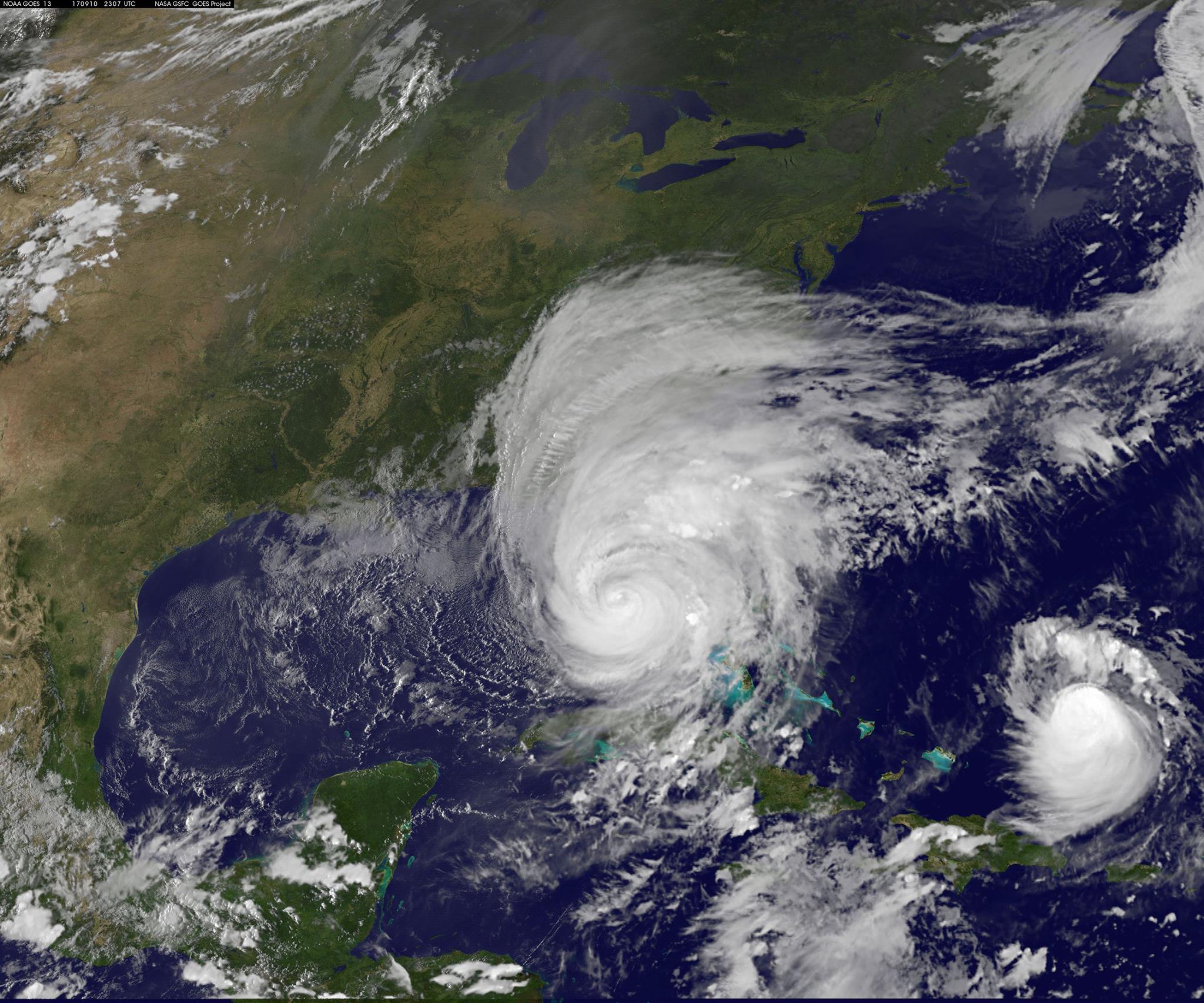
English: Satellite Sees Irma's Eye Near Fort Myers at 7:15 p.m. EDT
NOAA's GOES East satellite captured this image of Hurricane Irma at 2307 7:07 p.m. EDT when the eye was just southeast of Fort Myers. At 5 pm EDT (2100 UTC), the center of Hurricane Irma was located near latitude 26.2 North, longitude 81.8 West. Irma is moving toward the north near 14 mph (22 km/h), and a north-northwestward motion with an increase in forward speed is expected by tonight, with that motion continuing through Monday. On the forecast track, the eye of Irma should move near or over the west coast of the Florida Peninsula through Monday morning. Irma should then move inland over northern Florida and southwestern Georgia Monday afternoon. Maximum sustained winds are near 110 mph (175 km/h) with higher gusts. Although weakening is forecast, Irma is expected to remain a hurricane at least through Monday morning. Hurricane-force winds extend outward up to 80 miles (130 km) from the center, and tropical-storm-force winds extend outward up to 220 miles (350 km). A mesonet site at Naples Municipal Airport recently reported a sustained wind of 88 mph (142 km/h) with a gust to 135 mph (217 km/h) while in the northern eyewall of Irma. The minimum central pressure reported by an Air Force Hurricane Hunter aircraft is 938 mb (27.70 inches). A pressure of 937 mb (27.67 inches) was measured by a storm spotter on Marco Island while in Irma's eye |
| Date | |
| Source | https://www.facebook.com/NASAHurricane/photos/a.121853331194802.11206.112998395413629/1528703153843139/?type=3&theater |
| Author | NOAA |
Licensing
[edit]
This image is in the public domain because it contains materials that originally came from the U.S. National Oceanic and Atmospheric Administration, taken or made as part of an employee's official duties.
|
File history
Click on a date/time to view the file as it appeared at that time.
| Date/Time | Thumbnail | Dimensions | User | Comment | |
|---|---|---|---|---|---|
| current | 02:48, 11 February 2018 | | 2,048 × 1,706 (453 KB) | A1Cafel (talk | contribs) | User created page with UploadWizard |
You cannot overwrite this file.
File usage on Commons
The following page uses this file: