File:King George Island map-es.svg
(Redirected from File:Isla Rey Jorge (mapa-es).svg)
.svg&redirect=no)

Size of this PNG preview of this SVG file: 661 × 403 pixels. Other resolutions: 320 × 195 pixels | 640 × 390 pixels | 1,024 × 624 pixels | 1,280 × 780 pixels | 2,560 × 1,561 pixels.
Original file (SVG file, nominally 661 × 403 pixels, file size: 200 KB)
Captions
Captions
Add a one-line explanation of what this file represents
| Description |
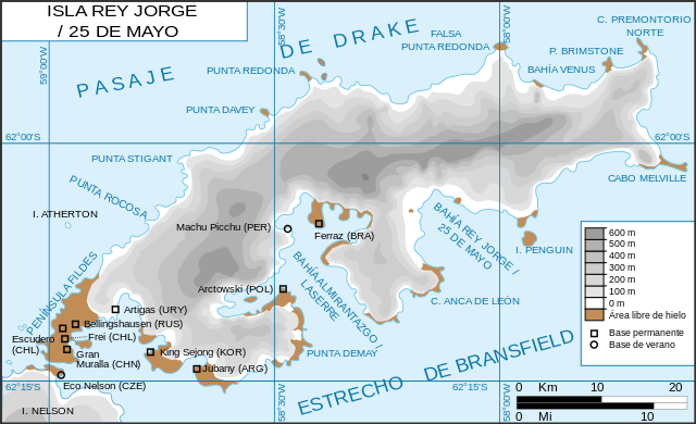
Français : Carte de l'île du Roi-George. Relief et stations de recherches English: King George Island map. Detailed. Relief. Research Stations. |
| Date | (UTC) |
| Source | |
| Author |
|
| Other versions |
Derivative works of this file: |
.svg)
| This is a retouched picture, which means that it has been digitally altered from its original version. Modifications: version espagnole. The original can be viewed here: Ile du roi-George (carte-fr).svg:
|
I, the copyright holder of this work, hereby publish it under the following licenses:
| This file is licensed under the Creative Commons Attribution-Share Alike 3.0 Unported license. | ||
| ||
| This licensing tag was added to this file as part of the GFDL licensing update. |

|
Permission is granted to copy, distribute and/or modify this document under the terms of the GNU Free Documentation License, Version 1.2 or any later version published by the Free Software Foundation; with no Invariant Sections, no Front-Cover Texts, and no Back-Cover Texts. A copy of the license is included in the section entitled GNU Free Documentation License. |
You may select the license of your choice.
Original upload log[edit]
This image is a derivative work of the following images:
- File:Ile_du_roi-George_(carte-fr).svg licensed with Cc-by-sa-3.0-migrated, GFDL
- 2010-04-18T21:10:06Z Trex 661x403 (266284 Bytes) {{Information |Description={{fr|1=Carte de l'île du Roi-George. Relief et stations de recherches}} {{en|1=King George Island map. Detailed. Relief. Research Stations.}} |Source=*[[:File:Kgeorge_map.png|]] |Date=2010-04-18 21:07
Uploaded with derivativeFX
File history
Click on a date/time to view the file as it appeared at that time.
| Date/Time | Thumbnail | Dimensions | User | Comment | |
|---|---|---|---|---|---|
| current | 15:52, 14 June 2010 | | 661 × 403 (200 KB) | Treehill (talk | contribs) | {{Information |Description={{fr|Carte de l'île du Roi-George. Relief et stations de recherches}} {{en|King George Island map. Detailed. Relief. Research Stations.}} |Source=*File:Ile_du_roi-George_(carte-fr).svg |Date=2010-06-14 15:52 (UTC) |Author |
You cannot overwrite this file.
File usage on Commons
The following page uses this file:
- File:Isla Rey Jorge (mapa-es).svg (file redirect)
File usage on other wikis
The following other wikis use this file:
- Usage on az.wikipedia.org
- Usage on cs.wikipedia.org
- Usage on de.wikipedia.org
- Usage on es.wikipedia.org
- Base Machu Picchu
- Isla Rey Jorge
- Base Presidente Eduardo Frei Montalva
- Base Profesor Julio Escudero
- Villa Las Estrellas
- Iglesia de la Santísima Trinidad (Antártida)
- Base Gran Muralla
- Bahía Fildes/Guardia Nacional
- Usuario:Pangui chileno/Taller
- Perú en la Antártida
- Escuela de Verano de Introducción a la Investigación Antártica
- Usage on fr.wikipedia.org
- Usage on no.wikipedia.org
- Usage on ru.wikipedia.org
- Usage on sv.wikipedia.org
- Usage on uk.wikipedia.org