File:Isle of Man topographic map-en.svg
跳至導覽
跳至搜尋

此 SVG 檔案的 PNG 預覽的大小:654 × 600 像素。 其他解析度:262 × 240 像素 | 524 × 480 像素 | 838 × 768 像素 | 1,117 × 1,024 像素 | 2,234 × 2,048 像素 | 1,200 × 1,100 像素。
原始檔案 (SVG 檔案,表面大小:1,200 × 1,100 像素,檔案大小:642 KB)
說明
說明
添加單行說明來描述出檔案所代表的內容

摘要
[編輯]
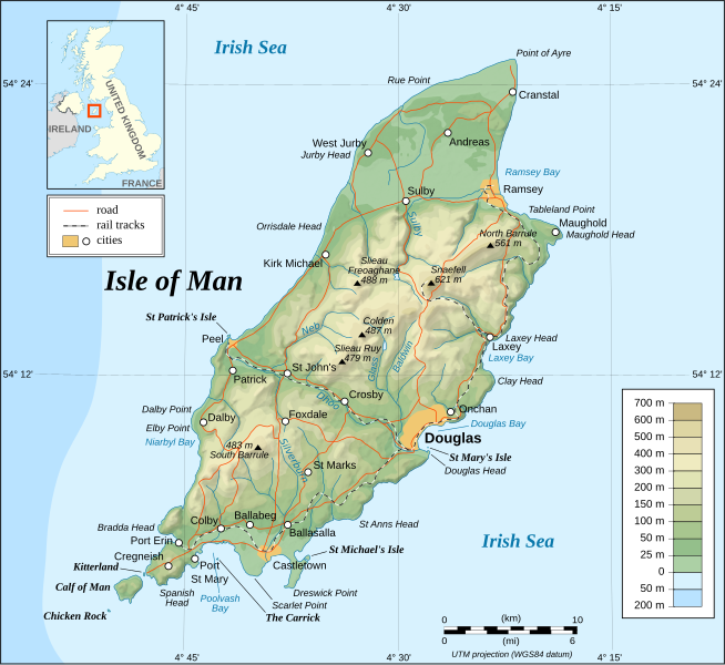
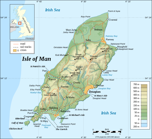
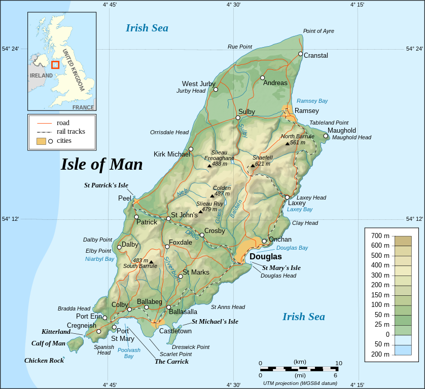
This image was selected as picture of the day on Wikimedia Commons for 26 November 2008. It was captioned as follows: English: Topographic map of the Isle of Man. Other languages:
Čeština: Topografická mapa Ostrova Man Dansk: Topografisk kort over Isle of Man. English: Topographic map of the Isle of Man. Français : Carte topographique en anglais de l'Île de Man. Íslenska: Staðfræðikort af eynni Mön. Italiano: Mappa topografica dell'Isola di Man. Magyar: Man sziget domborzati térképe Nederlands: Engelstalige topografische kaart van het Britse eiland Man Português: Mapa topográfico (em Inglês) da Ilha de Man. Română: Hartă topografică a Insulei Man Suomi: Mansaaren topografinen kartta. Svenska: Topografisk karta över Isle of Man. Русский: Топографическая карта Острова Мэн. 中文: 马恩岛地形图 中文(繁體): 曼島地形圖 |

| 描述 |
English: Topographic map in English of the Isle of Man.
Note : The shaded relief is a raster image embedded in the SVG. Français : Carte topographique en anglais de l'Île de Man.
Note : Le relief ombré est une image bitmap embarquée dans le fichier SVG. Português: Mapa topográfico (em Inglês) da Ilha de Man.
Русский: Топографическая карта Острова Мэн на английском языке UTM projection; WGS84 datum; shaded relief (composite image of N-W, W and N lightning positions); |
||
| 日期 | |||
| 來源 |
Own work ;
|
||
| 作者 | Eric Gaba (Sting - fr:Sting) | ||
| 授權許可 (重用此檔案) |
|
||
| 其他版本 |
此檔案衍生的作品: Isle of Man topographic map-ca.svg
[]
|


|
This SVG file contains embedded text that can be translated into your language, using any capable SVG editor, text editor or the SVG Translate tool. For more information see: About translating SVG files. |
授權條款
[編輯]
我,本作品的著作權持有者,決定用以下授權條款發佈本作品:

|
已授權您依據自由軟體基金會發行的無固定段落、封面文字和封底文字GNU自由文件授權條款1.2版或任意後續版本,對本檔進行複製、傳播和/或修改。該協議的副本列在GNU自由文件授權條款中。 |
| 此檔案採用創用CC 姓名標示-相同方式分享 3.0 未在地化版本授權條款。 | ||
| ||
| 已新增授權條款標題至此檔案,作為GFDL授權更新的一部份。 |
您可以選擇您需要的授權條款。
檔案歷史
點選日期/時間以檢視該時間的檔案版本。
| 日期/時間 | 縮圖 | 尺寸 | 使用者 | 備註 | |
|---|---|---|---|---|---|
| 目前 | 2008年9月4日 (四) 13:40 | | 1,200 × 1,100(642 KB) | Sting(留言 | 貢獻) | New standard colors |
| 2007年10月29日 (一) 23:19 |  | 1,200 × 1,100(745 KB) | Sting(留言 | 貢獻) | Some additional informations | |
| 2007年5月21日 (一) 20:55 |  | 1,200 × 1,100(742 KB) | Sting(留言 | 貢獻) | Some correction | |
| 2007年5月21日 (一) 18:24 |  | 1,200 × 1,100(742 KB) | Sting(留言 | 貢獻) | {{Information |Description=Topographic map in English of the Isle of Man |Source=Own work ;<br/>Topographic map : [http://www2.jpl.nasa.gov/srtm NASA Shuttle Radar Topography Mission] (SRTM3 v.2) (public domain) edited with [http://www |
無法覆蓋此檔案。
檔案用途
下列61個頁面有用到此檔案:
- Atlas of Isle of Man
- User:JoKalliauer/SVG test suites/Featured details
- User:Pfctdayelise/POTY07 categories/2007 list
- User:SVGbot/Results
- User:Sting/Gallery: Regional maps
- User talk:Sting/Archive 01
- Commons:Featured picture candidates/Image:Isle of Man topographic map-en.svg
- Commons:Featured picture candidates/Log/November 2007
- Commons:Featured pictures/Non-photographic media/Maps
- Commons:Featured pictures/chronological/2007-B
- Commons:Picture of the Year/2007/Galleries/All
- Commons:Picture of the Year/2007/Galleries/Graphic art and maps
- Commons:Picture of the Year/2007/Results/Round 1/Gallery
- Commons:Potd/2008-11 (de)
- Commons:Potd/2008-11 (eo)
- Commons:Potd/2008-11 (nl)
- Commons:Potd/2008-11 (pl)
- Commons:Potd/2008-11 (pt)
- Commons:Potd/2008-11 (tr)
- Commons:Potd/2008-11 (zh-hant)
- Commons talk:Project Mapmaking Wiki Standards/Archive01
- File:Isle of Man map-en.svg
- File:Isle of Man map-fr.svg
- File:Isle of Man topographic map-ca.svg
- File:Isle of Man topographic map-de.svg
- File:Isle of Man topographic map-el.svg
- File:Isle of Man topographic map-en.svg
- File:Isle of Man topographic map-es.svg
- File:Isle of Man topographic map-fr.svg
- File:Isle of Man topographic map-hu.svg
- File:Isle of Man topographic map-it.svg
- File:Isle of Man topographic map-mk.svg
- File:Isle of Man topographic map-nb.svg
- File:Isle of Man topographic map-ru.svg
- Template:Other versions/Isle of Man topographic map
- Template:Potd/2008-11
- Template:Potd/2008-11-26
- Template:Potd/2008-11-26 (cs)
- Template:Potd/2008-11-26 (cy)
- Template:Potd/2008-11-26 (da)
- Template:Potd/2008-11-26 (de)
- Template:Potd/2008-11-26 (en)
- Template:Potd/2008-11-26 (es)
- Template:Potd/2008-11-26 (fi)
- Template:Potd/2008-11-26 (fr)
- Template:Potd/2008-11-26 (hu)
- Template:Potd/2008-11-26 (is)
- Template:Potd/2008-11-26 (it)
- Template:Potd/2008-11-26 (nl)
- Template:Potd/2008-11-26 (pam)
- Template:Potd/2008-11-26 (pl)
- Template:Potd/2008-11-26 (pt)
- Template:Potd/2008-11-26 (ro)
- Template:Potd/2008-11-26 (ru)
- Template:Potd/2008-11-26 (sv)
- Template:Potd/2008-11-26 (uk)
- Template:Potd/2008-11-26 (zh-hans)
- Template:Potd/2008-11-26 (zh-hant)
- Template:Potd/2008-11 (ro)
- Template:Potd/2008-11 (zh-hans)
- Category:Geography of the Isle of Man
全域檔案使用狀況
以下其他 wiki 使用了這個檔案:
- af.wikipedia.org 的使用狀況
- bn.wikipedia.org 的使用狀況
- cs.wikipedia.org 的使用狀況
- da.wikipedia.org 的使用狀況
- de.wikipedia.org 的使用狀況
- en.wikipedia.org 的使用狀況
- fi.wikipedia.org 的使用狀況
- fr.wikipedia.org 的使用狀況
- gv.wikipedia.org 的使用狀況
- hu.wikipedia.org 的使用狀況
- ko.wikipedia.org 的使用狀況
- nl.wikipedia.org 的使用狀況
- pl.wikipedia.org 的使用狀況
- pt.wikipedia.org 的使用狀況
- sc.wikipedia.org 的使用狀況
- simple.wikipedia.org 的使用狀況
- sk.wikipedia.org 的使用狀況
- sv.wikipedia.org 的使用狀況
- tr.wikipedia.org 的使用狀況
- uk.wikipedia.org 的使用狀況
- www.wikidata.org 的使用狀況
- zh.wikipedia.org 的使用狀況