File:Isle of Wight UK relief location map.jpg
Aller à la navigation
Aller à la recherche

Taille de cet aperçu : 800 × 487 pixels. Autres résolutions : 320 × 195 pixels | 640 × 390 pixels | 1 024 × 624 pixels | 1 280 × 780 pixels | 1 999 × 1 218 pixels.
Fichier d’origine (1 999 × 1 218 pixels, taille du fichier : 158 kio, type MIME : image/jpeg)
Légendes
Légendes
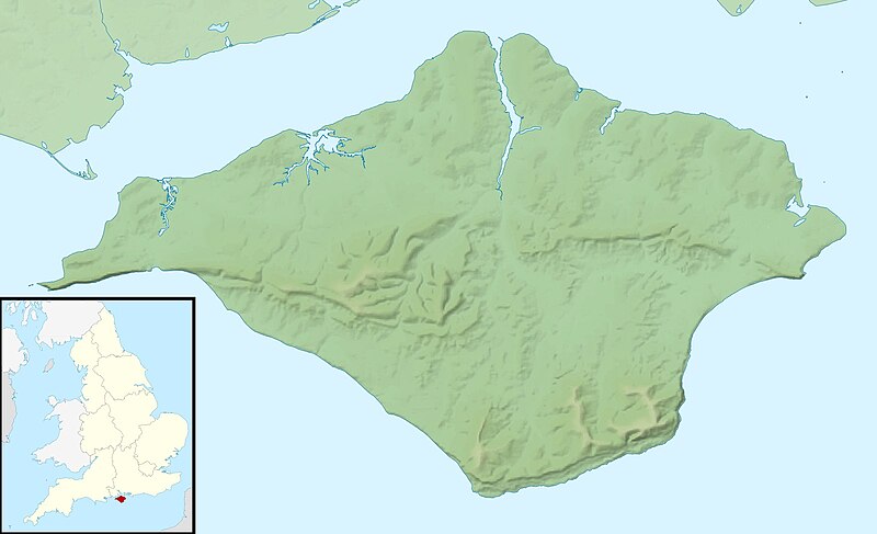
Carte (muette, géoréférencée) du relief de l'île de Wight, du Royaume-Uni
| Description |
Relief map of the Isle of Wight, UK. Equirectangular map projection on WGS 84 datum, with N/S stretched 155% Geographic limits:
|
| Date | |
| Source |
|
| Auteur | Nilfanion, created using Ordnance Survey data |
| Autorisation (Réutilisation de ce fichier) |
Ce fichier est disponible selon les termes de la licence Creative Commons Attribution – Partage dans les Mêmes Conditions 3.0 (non transposée). Attribution: Contains Ordnance Survey data © Crown copyright and database right
|
| Autres versions | File:Isle of Wight UK district map (blank).svg - Blank map |
.svg)
Historique du fichier
Cliquer sur une date et heure pour voir le fichier tel qu'il était à ce moment-là.
| Date et heure | Vignette | Dimensions | Utilisateur | Commentaire | |
|---|---|---|---|---|---|
| actuel | 29 novembre 2011 à 01:41 | | 1 999 × 1 218 (158 kio) | Nilfanion (d | contributions) | {{Information |Description=Relief map of the Isle of Wight, UK. Equirectangular map projection on WGS 84 datum, with N/S stretched 155% Geographic limits: *West: 1.61W *East: 1.05W *North: 50.78N *South: 50.56N |Source=[[w:Ordnance S |
Vous ne pouvez pas remplacer ce fichier.
Utilisations locales du fichier
Aucune page n’utilise ce fichier.
Utilisations du fichier sur d’autres wikis
Les autres wikis suivants utilisent ce fichier :
- Utilisation sur ar.wikipedia.org
- Utilisation sur bg.wikipedia.org
- Utilisation sur ceb.wikipedia.org
- Utilisation sur en.wikipedia.org
- St Boniface Down
- Module:Location map/data/United Kingdom Isle of Wight/doc
- Whale Chine
- Widdick Chine
- Scratchell's Bay
- Totland Bay
- Watcombe Bay
- Bembridge Lifeboat Station
- Yarmouth Lifeboat Station
- Ryde Inshore Rescue Service
- Freshwater Bay Independent Lifeboat Station
- Sandown and Shanklin Independent Lifeboat Station
- Module:Location map/data/United Kingdom Isle of Wight
- Module:Location map/data/Isle of Wight
- User:KnightStryker/sandbox/Freshwater Independent Lifeboat Station
- Hunny Hill
- Woodlands Vale
- Utilisation sur es.wikipedia.org
- Utilisation sur fr.wikipedia.org
- Utilisation sur ja.wikipedia.org
- Utilisation sur kn.wikipedia.org
- Utilisation sur la.wikipedia.org
- Utilisation sur lv.wikipedia.org
- Utilisation sur ml.wikipedia.org
- Utilisation sur ms.wikipedia.org
- Utilisation sur nl.wikipedia.org
- Utilisation sur os.wikipedia.org
- Utilisation sur pl.wikipedia.org
- Utilisation sur pl.wikibooks.org
- Utilisation sur sco.wikipedia.org
- Utilisation sur simple.wikipedia.org
Voir davantage sur l’utilisation globale de ce fichier.