File:Isle of Wight UK relief location map.jpg
Pāriet uz navigāciju
Pāriet uz meklēšanu

Šī priekšskata izmērs: 800 × 487 pikseļi. Citi izmēri: 320 × 195 pikseļi | 640 × 390 pikseļi | 1 024 × 624 pikseļi | 1 280 × 780 pikseļi | 1 999 × 1 218 pikseļi.
Sākotnējais fails (1 999 × 1 218 pikseļi, faila izmērs: 158 KB, MIME tips: image/jpeg)
Captions
Captions
Pievieno vienas rindiņas aprakstu, ko šis fails attēlo
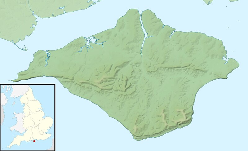
Relief map of the Isle of Wight, UK
| Apraksts |
Relief map of the Isle of Wight, UK. Equirectangular map projection on WGS 84 datum, with N/S stretched 155% Geographic limits:
|
| Datums | |
| Avots |
|
| Autors | Nilfanion, created using Ordnance Survey data |
| Atļauja: (Šī faila izmantošana citur) |
Šis fails tiek izplatīts saskaņā ar licences Creative Commons Atsauce-Līdzīgi Noteikumi 3.0 Vispārējiem noteikumiem. Atsauce: Contains Ordnance Survey data © Crown copyright and database right
|
| Citas versijas | File:Isle of Wight UK district map (blank).svg - Blank map |
.svg)
Faila hronoloģija
Uzklikšķini uz datums/laiks kolonnā esošās saites, lai apskatītos, kā šis fails izskatījās tad.
| Datums/Laiks | Attēls | Izmēri | Dalībnieks | Komentārs | |
|---|---|---|---|---|---|
| tagadējais | 2011. gada 29. novembris, plkst. 01.41 | | 1 999 × 1 218 (158 KB) | Nilfanion (diskusija | devums) | {{Information |Description=Relief map of the Isle of Wight, UK. Equirectangular map projection on WGS 84 datum, with N/S stretched 155% Geographic limits: *West: 1.61W *East: 1.05W *North: 50.78N *South: 50.56N |Source=[[w:Ordnance S |
Šo failu nevar pārrakstīt.
Faila lietojums
Šo failu neizmanto nevienā lapā.
Globālais faila lietojums
Šīs Vikipēdijas izmanto šo failu:
- Izmantojums ar.wikipedia.org
- Izmantojums bg.wikipedia.org
- Izmantojums ceb.wikipedia.org
- Izmantojums en.wikipedia.org
- St Boniface Down
- Module:Location map/data/United Kingdom Isle of Wight/doc
- Whale Chine
- Widdick Chine
- Scratchell's Bay
- Totland Bay
- Watcombe Bay
- Bembridge Lifeboat Station
- Yarmouth Lifeboat Station
- Ryde Inshore Rescue Service
- Freshwater Bay Independent Lifeboat Station
- Sandown and Shanklin Independent Lifeboat Station
- Module:Location map/data/United Kingdom Isle of Wight
- Module:Location map/data/Isle of Wight
- User:KnightStryker/sandbox/Freshwater Independent Lifeboat Station
- Isle of Wight Jewish Society
- Hunny Hill
- Woodlands Vale
- Izmantojums es.wikipedia.org
- Izmantojums fr.wikipedia.org
- Izmantojums ja.wikipedia.org
- Izmantojums kn.wikipedia.org
- Izmantojums la.wikipedia.org
- Izmantojums lv.wikipedia.org
- Izmantojums ml.wikipedia.org
- Izmantojums ms.wikipedia.org
- Izmantojums nl.wikipedia.org
- Izmantojums os.wikipedia.org
- Izmantojums pl.wikipedia.org
- Izmantojums pl.wikibooks.org
- Izmantojums sco.wikipedia.org
- Izmantojums simple.wikipedia.org
Skatīt šī faila pilno globālo izmantojumu.