File:Italy 1494 AD-it.svg
Salta a la navegació
Salta a la cerca

Mida d'aquesta previsualització PNG del fitxer SVG: 443 × 599 píxels. Altres resolucions: 177 × 240 píxels | 355 × 480 píxels | 568 × 768 píxels | 757 × 1.024 píxels | 1.515 × 2.048 píxels | 688 × 930 píxels.
Fitxer original (fitxer SVG, nominalment 688 × 930 píxels, mida del fitxer: 418 Ko)
Llegendes
Llegendes
Afegeix una explicació d'una línia del que representa aquest fitxer

Resum[modifica]
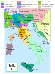
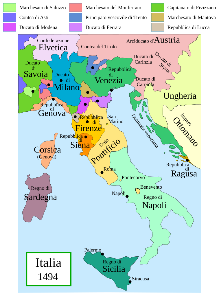
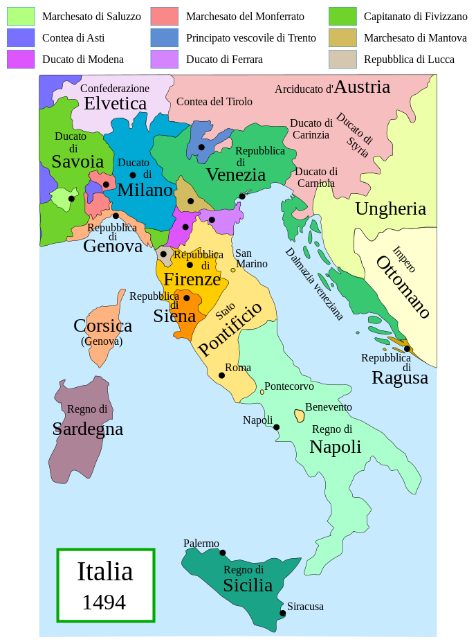
Political map of Italy in early 1494, before the invasion of Italy by Charles VIII of France, created by MapMaster.
This is a companion map to Image:Italy 1000 AD.svg, Image:Italy 1796.png, and Image:Italy c 1810.png.

|
Aquest fitxer SVG inclou text encapsulat que es pot traduir al vostre idioma utilitzant un editor que admeti SVG, un editor de text o l'eina de traducció de SVG. Per a més informació vegeu l'ajuda de traducció de fitxers SVG. |
Versions[modifica]
[]
PNG:
-
 àrab
àrab -
 anglès
 -
 grec
grec


SVG:
-
 francès
 -
 italià
 -
 hongarès


References[modifica]
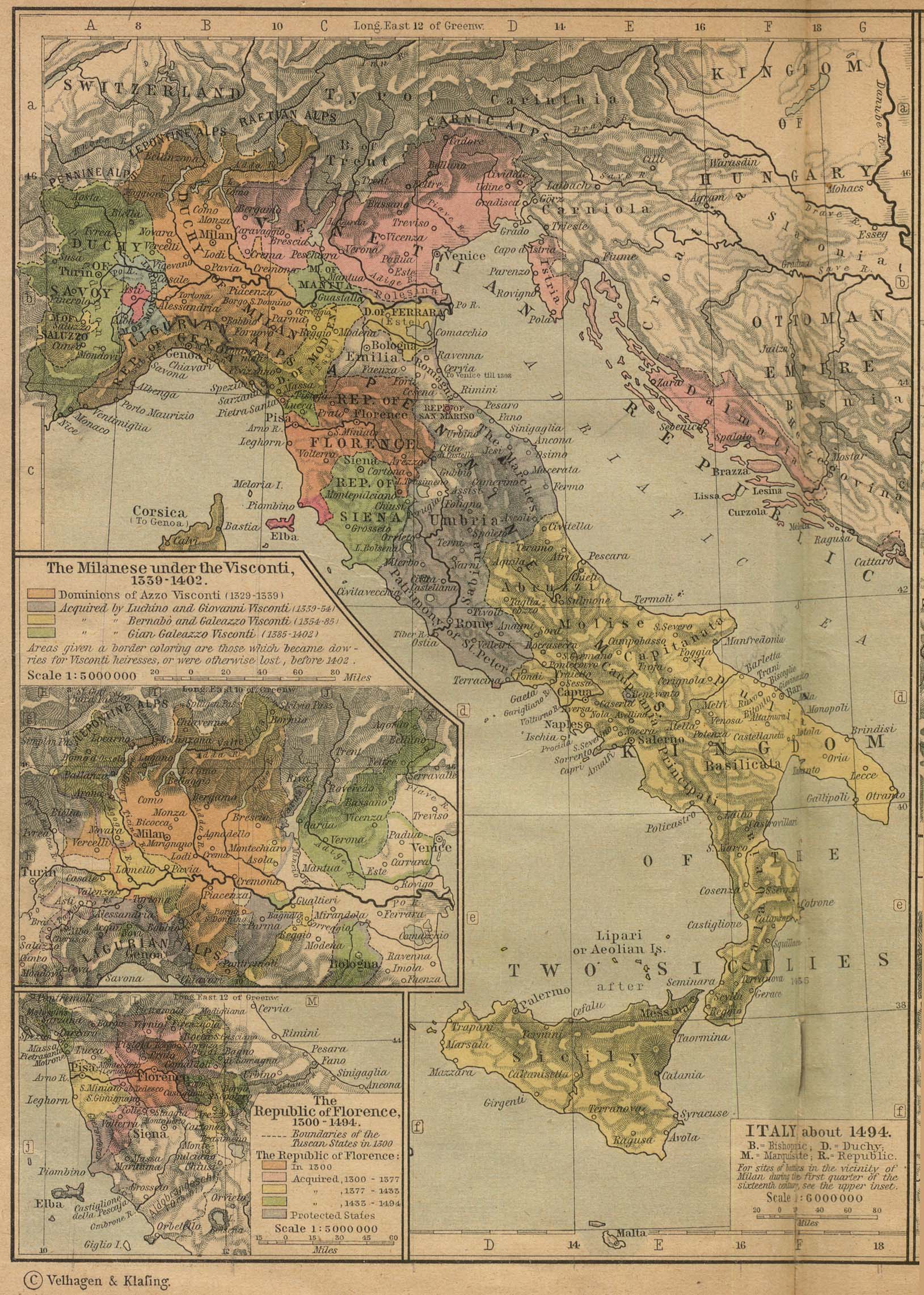
- Bjorklund, Oddvar; Holmboe, Haakon; Rohr, Anders (1970) Historical Atlas of the World, Barnes & Noble, NY, SBN: 389-00253-4.
- Matthew, Donald, (1983), Atlas of Medieval Europe, Checkmark Books, New York.
- Online maps, including this 1882 map from Shepherd (the University of Texas)
- this one from A B Longman, textbook publisher.
Llicència[modifica]
Jo, el titular dels drets d'autor d'aquest treball, el public sota les següents llicències:

|
S'autoritza la còpia, la distribució i la modificació d'aquest document sota els termes de la llicència de documentació lliure GNU versió 1.2 o qualsevol altra versió posterior que publiqui la Free Software Foundation; sense seccions invariants, ni textos de portada, ni textos de contraportada. S'inclou una còpia d'aquesta llicència en la secció titulada GNU Free Documentation License. |
| Aquest fitxer està subjecte a la llicència de Creative Commons Reconeixement i Compartir Igual 3.0 No adaptada. | ||
| ||
| Aquest avís de llicència s'ha afegit a aquest fitxer d'acord amb l'actualització de la llicència GFDL. |
Aquest fitxer està llicenciat sota les llicències de Creative Commons Reconeixement - CompartirIgual 2.5 Genèrica, 2.0 Genèrica i 1.0 Genèrica.
- Sou lliure de:
- compartir – copiar, distribuir i comunicar públicament l'obra
- adaptar – fer-ne obres derivades
- Amb les condicions següents:
- reconeixement – Heu de donar la informació adequada sobre l'autor, proporcionar un enllaç a la llicència i indicar si s'han realitzat canvis. Podeu fer-ho amb qualsevol mitjà raonable, però de cap manera no suggereixi que l'autor us dóna suport o aprova l'ús que en feu.
- compartir igual – Si modifiqueu, transformeu, o generareu amb el material, haureu de distribuir les vostres contribucions sota una llicència similar o una de compatible com l'original
Podeu seleccionar la llicència que vulgueu.
derivative works[modifica]
Derivative works of this file: Italy 1494 AD-fr.svg
Historial del fitxer
Cliqueu una data/hora per veure el fitxer tal com era aleshores.
| Data/hora | Miniatura | Dimensions | Usuari/a | Comentari | |
|---|---|---|---|---|---|
| actual | 18:27, 28 juny 2013 | | 688 × 930 (418 Ko) | Fulvio314 (discussió | contribucions) | Legenda, added small territories |
| 20:46, 26 maig 2013 |  | 576 × 812 (417 Ko) | Fulvio314 (discussió | contribucions) | Font | |
| 15:31, 27 feb 2007 |  | 567 × 812 (1,17 Mo) | MapMaster (discussió | contribucions) | Some modifications based on feedback from User:Paolo da Reggio | |
| 03:31, 23 feb 2007 |  | 567 × 812 (1,17 Mo) | MapMaster (discussió | contribucions) | Italia, 1494. |
No podeu sobreescriure aquest fitxer.
Ús del fitxer
Les 21 pàgines següents utilitzen aquest fitxer:
- Maps of the Italian Risorgimento
- User:Fulvio314/commons gallery
- File:Italia 1494.svg (fitxer redirigit)
- File:Italy 1494 AD-ar.png
- File:Italy 1494 AD-fr.svg
- File:Italy 1494 AD-hu.svg
- File:Italy 1494 AD-it.svg
- File:Italy 1494 AD.png
- File:Italy 1494 el.png
- File:Italy and Illyria 1084 AD-it.svg
- Template:Other versions/Italy 1494 AD
- Category:Marquisate of Saluzzo
- Category:Republic of Siena
Ús global del fitxer
Utilització d'aquest fitxer en altres wikis:
- Utilització a ar.wikipedia.org
- Utilització a ast.wikipedia.org
- Utilització a bg.wikipedia.org
- Utilització a br.wikipedia.org
- Utilització a ca.wikipedia.org
- Utilització a el.wikipedia.org
- Utilització a en.wikipedia.org
- Utilització a eo.wikipedia.org
- Utilització a eu.wikipedia.org
- Utilització a fi.wikipedia.org
- Utilització a fr.wikipedia.org
- Utilització a hu.wikipedia.org
- Utilització a it.wikipedia.org
- Utilització a it.wikiquote.org
- Utilització a ja.wikipedia.org
- Utilització a ko.wikipedia.org
- Utilització a la.wikipedia.org
- Utilització a nn.wikipedia.org
- Utilització a ru.wikipedia.org
- Utilització a uk.wikipedia.org
- Utilització a www.wikidata.org
- Utilització a zh.wikipedia.org