File:Italy 1494 AD.png
Aller à la navigation
Aller à la recherche

Taille de cet aperçu : 419 × 600 pixels. Autres résolutions : 168 × 240 pixels | 335 × 480 pixels | 536 × 768 pixels | 1 261 × 1 805 pixels.
Fichier d’origine (1 261 × 1 805 pixels, taille du fichier : 144 kio, type MIME : image/png)
Légendes
Légendes
Ajoutez en une ligne la description de ce que représente ce fichier
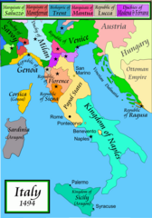
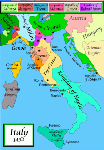
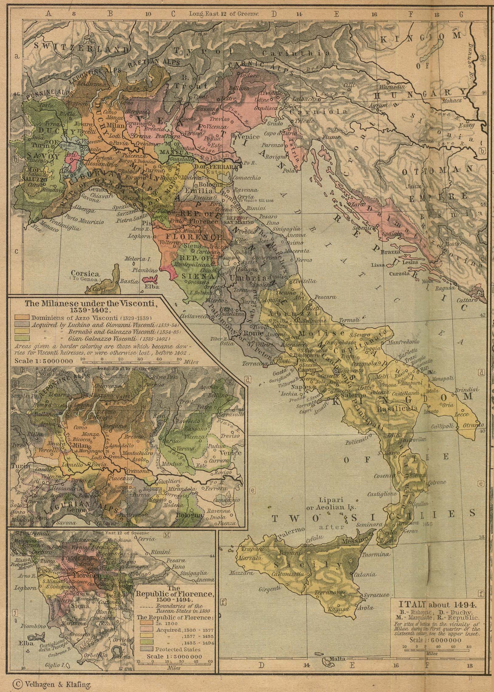
A political map of the Italian Peninsula circa 1494


|
Une version vectorielle de cette image existe, dans le format « SVG ». Si elle n’est pas inférieure, elle devrait être utilisée à la place de la présente version pour des affichages en plus grandes dimensions ou nécessitant une meilleure résolution.
File:Italy 1494 AD.png → File:Italy 1494 AD-it.svg
Pour plus d’informations sur les images vectorielles, consultez la page de transition de Commons vers le format SVG. Voir aussi les informations à propos de la manière dont le logiciel MediaWiki gère les images au format SVG. |
 |
Description
[modifier]Political map of Italy in early 1494, before the invasion of Italy by Charles VIII of France, created by MapMaster.
Part of a series of maps on the history of Italy:
-
 1000 AD
 -
 1084 AD
 -
 1796 AD
 -
 1810 AD


Versions
[modifier][]
PNG:
-
 arabe
arabe -
 anglais
 -
 grec
grec


SVG:
-
 catalan
 -
 espagnol
 -
 français
 -
 italien
 -
 hongrois


See similar versions (disputed too): Map of Italy (1494)
References
[modifier]
- Bjorklund, Oddvar; Holmboe, Haakon; Rohr, Anders (1970) Historical Atlas of the World, Barnes & Noble, NY, SBN: 389-00253-4.
- Matthew, Donald, (1983), Atlas of Medieval Europe, Checkmark Books, New York.
- Online maps, including this 1882 map from Shepherd (the University of Texas)
- this one from A B Longman, textbook publisher.
Conditions d’utilisation
[modifier]
Moi, en tant que détenteur des droits d’auteur sur cette œuvre, je la publie sous les licences suivantes :

|
Vous avez la permission de copier, distribuer et modifier ce document selon les termes de la GNU Free Documentation License version 1.2 ou toute version ultérieure publiée par la Free Software Foundation, sans sections inaltérables, sans texte de première page de couverture et sans texte de dernière page de couverture. Un exemplaire de la licence est inclus dans la section intitulée GNU Free Documentation License. |
| Ce fichier est disponible selon les termes de la licence Creative Commons Attribution – Partage dans les Mêmes Conditions 3.0 (non transposée). | ||
| ||
| Ce bandeau de licence a été ajouté à ce fichier dans le cadre de la procédure de mise à jour des licences des images sous GFDL. |
Vous pouvez choisir l’une de ces licences.
derivative works
[modifier]
Œuvres dérivées de ce fichier : Italy 1494 AD-ar.png
Historique du fichier
Cliquer sur une date et heure pour voir le fichier tel qu'il était à ce moment-là.
| Date et heure | Vignette | Dimensions | Utilisateur | Commentaire | |
|---|---|---|---|---|---|
| actuel | 21 avril 2009 à 01:15 | | 1 261 × 1 805 (144 kio) | Capmo (d | contributions) | palette reduction to 256 colours |
| 14 avril 2007 à 22:04 |  | 1 261 × 1 805 (539 kio) | MapMaster (d | contributions) | Minor modifications | |
| 27 février 2007 à 16:07 |  | 1 167 × 1 642 (471 kio) | MapMaster (d | contributions) | Modification suggested by User:Paolo da Reggio | |
| 8 janvier 2007 à 23:52 |  | 1 135 × 1 625 (472 kio) | MapMaster (d | contributions) | Political map of Italy in early 1494, before the invasion of Italy by Charles VIII of France, created by MapMaster. |
Vous ne pouvez pas remplacer ce fichier.
Utilisations locales du fichier
Les 96 pages suivantes utilisent ce fichier :
- Atlas of Italy
- User:MapMaster
- File:Duchy of Carinthia-1000 AD.svg
- File:Italia 1000 AD-Ido.svg
- File:Italia 1494-ca.svg
- File:Italia 1494-es.svg
- File:Italia 1494-it.svg
- File:Italia 1494-ua.svg
- File:Italia 1494b-ca.svg
- File:Italia 1494b-es.svg
- File:Italia 1796-ca.svg
- File:Italia 1796-es.svg
- File:Italia 1796-fr.svg
- File:Italia 1796.svg
- File:Italia 1796 - HE.svg
- File:Italy 1000 AD-de.svg
- File:Italy 1000 AD-es.svg
- File:Italy 1000 AD-he.svg
- File:Italy 1000 AD-ru.svg
- File:Italy 1000 AD.svg
- File:Italy 1494-fr.svg
- File:Italy 1494.svg
- File:Italy 1494 AD-ar.png
- File:Italy 1494 AD-fr.svg
- File:Italy 1494 AD-it.svg
- File:Italy 1494 AD.png
- File:Italy 1494 de.svg
- File:Italy 1494 el.png
- File:Italy 1494 shepherd.jpg
- File:Italy 1494 v2.png (redirection de fichier)
- File:Italy 1494 shepherd.jpg
- User:MapMaster
- File:Italy 1000 AD.svg
- Atlas of Italy
- File:Italy 1494 AD.png
- File:Italy and Illyria 1084 AD.svg
- File:Italy 1494 AD-it.svg
- File:Italy 1796 AD-it.png
- File:Italy 1000 AD-de.svg
- File:Map of Italy (1494)-it.svg
- File:Italy 1000 AD-es.svg
- File:Map of Italy (1494)-ca.svg
- File:Italy 1000 AD-he.svg
- File:Italy 1000 AD-ru.svg
- File:Italy and Illyria 1084 AD-ru.svg
- File:Italy 1796 heb.jpg
- File:Map of Italy (1494)-mk.svg
- File:Map of Italy (1494)-en.svg
- File:Italia 1796.svg
- File:Italia 1796 - HE.svg
- File:Italy 1494 AD-ar.png
- File:Duchy of Carinthia-1000 AD.svg
- File:Italia 1796-es.svg
- File:Italia 1494-es.svg
- File:Italy 1796.svg
- File:Italy 1494.svg
- File:Map of Italy (1494)-pl.svg
- File:Italia 1796-fr.svg
- File:Italia 1494-it.svg
- File:Italy 1494 de.svg
- File:Italy 1796 de.svg
- File:Italy 1494 AD-fr.svg
- File:Italy 1796 it.svg
- File:Italy 1796 AD-el.png
- File:Italy 1494 el.png
- File:Italia 1494b-es.svg
- Template:Other versions/Italy 1796 AD
- Template:Other versions/Italy 1494 AD
- File:Italy 1494-fr.svg
- File:Italy 1796-hu.svg
- File:Italia 1494-ua.svg
- File:Italia 1000 AD-Ido.svg
- File:Italia 1494-ca.svg
- Template:Other versions/Map of Italy (1494)
- File:Italia 1796-ca.svg
- File:Italy 1796 AD-ca.svg
- File:Italia 1494b-ca.svg
- File:Italy 1796-hu.svg
- File:Italy 1796.svg
- File:Italy 1796 AD-ca.svg
- File:Italy 1796 AD-el.png
- File:Italy 1796 AD-it.png
- File:Italy 1796 de.svg
- File:Italy 1796 heb.jpg
- File:Italy 1796 it.svg
- File:Italy and Illyria 1084 AD-ru.svg
- File:Italy and Illyria 1084 AD.svg
- File:Map of Italy (1494)-ca.svg
- File:Map of Italy (1494)-en.svg
- File:Map of Italy (1494)-it.svg
- File:Map of Italy (1494)-mk.svg
- File:Map of Italy (1494)-pl.svg
- Template:Other versions/Italy 1494 AD
- Template:Other versions/Italy 1796 AD
- Template:Other versions/Map of Italy (1494)
- Category:Italian War of 1494–1495
-it.svg)
-ca.svg)
-mk.svg)
-en.svg)
-pl.svg)
Utilisations du fichier sur d’autres wikis
Les autres wikis suivants utilisent ce fichier :
- Utilisation sur af.wikipedia.org
- Utilisation sur azb.wikipedia.org
- Utilisation sur az.wikipedia.org
- Utilisation sur bg.wikipedia.org
- Utilisation sur br.wikipedia.org
- Utilisation sur bxr.wikipedia.org
- Utilisation sur cs.wikipedia.org
- Utilisation sur de.wikipedia.org
- Utilisation sur el.wikipedia.org
- Utilisation sur en.wikipedia.org
- Pope Alexander VI
- Renaissance
- Italian Wars
- Gonzalo Fernández de Córdoba
- Duke of Ferrara and of Modena
- Italian War of 1494–1495
- List of rulers of Montferrat
- User:MapMaster
- Military history of Italy
- User:Juanpdp/Italy
- User:Bolonium/Renaissance
- Marquisate of Incisa
- Timeline of Niccolò Machiavelli
- Italic League
- User:Falcaorib/Italy
- Utilisation sur eo.wikipedia.org
- Utilisation sur es.wikipedia.org
- Utilisation sur et.wikipedia.org
- Utilisation sur fa.wikipedia.org
- Utilisation sur fr.wikipedia.org
Voir davantage sur l’utilisation globale de ce fichier.