File:Italy unification 1815 1870.jpg
跳至導覽
跳至搜尋

預覽大小:553 × 600 像素。 其他解析度:221 × 240 像素 | 442 × 480 像素 | 708 × 768 像素 | 1,073 × 1,164 像素。
原始檔案 (1,073 × 1,164 像素,檔案大小:480 KB,MIME 類型:image/jpeg)
說明
說明
添加單行說明來描述出檔案所代表的內容
摘要
[編輯]| 描述 |
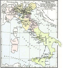
English: Map of unification of Italy, 1815-70 |
| 日期 | 2005年12月17日 (原始上傳日期) |
| 來源 | Shepherd, William. Historical Atlas. New York: Henry Holt and Company, 1911 |
| 作者 | 原上傳者為荷蘭文維基百科的Känsterle |
| 其他版本 | File:Italia1815.jpg |
.jpg)
授權條款
[編輯]
|
此為如實地拍攝平面藝術品的相片複製本。原作位於公有領域,是因下列原因:
維基媒體基金會的官方立場認為:「針對平面公有領域的藝術作品進行忠實重製,其重製後的照片也屬於公有領域。」
因此,可認定本重製照片屬於公有領域。在其他司法管轄區,再利用此照片可能會被限制;參見再利用PD-Art照片以獲得進一步資訊。 | ||||
原始上傳日誌
[編輯]
The original description page was here. All following user names refer to nl.wikipedia.
- 2005-12-17 17:25 Känsterle 1073×1164× (271891 bytes) Italiaanse eenwording {{texas}}

|
File:Unification of Italy 1815-1924.svg是本檔案的向量版本。 如果品質不低,就應該優先使用該檔案,而非JPG檔案。
File:Italy unification 1815 1870.jpg → File:Unification of Italy 1815-1924.svg
更多資訊請參閱Help:SVG/zh。 |
 |
檔案歷史
點選日期/時間以檢視該時間的檔案版本。
| 日期/時間 | 縮圖 | 尺寸 | 使用者 | 備註 | |
|---|---|---|---|---|---|
| 目前 | 2013年8月11日 (日) 04:46 | | 1,073 × 1,164(480 KB) | Alphathon(留言 | 貢獻) | Increased colour density |
| 2013年8月11日 (日) 04:43 |  | 1,073 × 1,164(472 KB) | Alphathon(留言 | 貢獻) | Re-edited from original version | |
| 2011年3月18日 (五) 22:23 |  | 1,055 × 1,152(280 KB) | A7N8X(留言 | 貢獻) | Color correct | |
| 2011年3月17日 (四) 11:01 |  | 1,055 × 1,152(306 KB) | A7N8X(留言 | 貢獻) | cleared from the watermark image, improved compression. jpeg, making it progressively improving and quick viewing | |
| 2009年10月7日 (三) 12:04 |  | 1,073 × 1,164(266 KB) | BotMultichill(留言 | 貢獻) | {{BotMoveToCommons|nl.wikipedia|year={{subst:CURRENTYEAR}}|month={{subst:CURRENTMONTHNAME}}|day={{subst:CURRENTDAY}}}} {{Information |Description={{nl|Italiaanse eenwording [[:nl:Afbeelding:Unification of Italy 1815-1870.jpg|thumb|left|Zelfde kaart m |
無法覆蓋此檔案。
檔案用途
下列2個頁面有用到此檔案:
全域檔案使用狀況
以下其他 wiki 使用了這個檔案:
- als.wikipedia.org 的使用狀況
- ar.wikipedia.org 的使用狀況
- ast.wikipedia.org 的使用狀況
- azb.wikipedia.org 的使用狀況
- be.wikipedia.org 的使用狀況
- bg.wikipedia.org 的使用狀況
- br.wikipedia.org 的使用狀況
- ca.wikipedia.org 的使用狀況
- da.wikipedia.org 的使用狀況
- Wienerkongressen
- Kirkestaten
- Risorgimento
- Giuseppe Garibaldi
- Kongeriget Sardinien
- Kongeriget Lombardiet-Venetien
- Kongeriget Begge Sicilier
- Victor Emanuel 2. af Italien
- Kongeriget Italien
- Giuseppe Mazzini
- Anden Italienske Uafhængighedskrig
- Første Italienske Uafhængighedskrig
- Mellemitaliens Forenede Provinser
- Hertugdømmet Parma
- Storhertugdømmet Toscana
- Hertugdømmet Modena
- Hertugdømmet Lucca
- Skabelon:Italiens samling
- Camillo di Cavour
- Tredje Italienske Uafhængighedskrig
- de.wikipedia.org 的使用狀況
- el.wikipedia.org 的使用狀況
- en.wikipedia.org 的使用狀況
- eo.wikipedia.org 的使用狀況
- es.wikipedia.org 的使用狀況
- et.wikipedia.org 的使用狀況
- eu.wikipedia.org 的使用狀況
- fa.wikipedia.org 的使用狀況
- fiu-vro.wikipedia.org 的使用狀況
- fi.wikipedia.org 的使用狀況
檢視此檔案的更多全域使用狀況。
詮釋資料
分類:
- Maps showing history by William R. Shepherd
- 1815 in Italy
- 1870 in Italy
- Maps of Italian Risorgimento
- 19th-century maps of Italy
- Old Maps of the Italian Peninsula in History
- Kingdom of Sardinia
- Maps of the history of Sardinia
- Maps of the Kingdom of the Two Sicilies
- Maps of the Kingdom of Lombardy-Venetia
- Maps of the Duchy of Parma and Piacenza
- Maps of Duchy of Modena and Reggio
- Maps of the Grand Duchy of Tuscany
- Maps of the Papal States
- Papal States in the 19th century