File:Ivan 2004 track.png
Aller à la navigation
Aller à la recherche

Taille de cet aperçu : 800 × 495 pixels. Autres résolutions : 320 × 198 pixels | 640 × 396 pixels | 1 024 × 633 pixels | 1 280 × 791 pixels | 2 700 × 1 669 pixels.
Fichier d’origine (2 700 × 1 669 pixels, taille du fichier : 1,98 Mio, type MIME : image/png)
Légendes
Légendes
Ajoutez en une ligne la description de ce que représente ce fichier
Description
| Description |
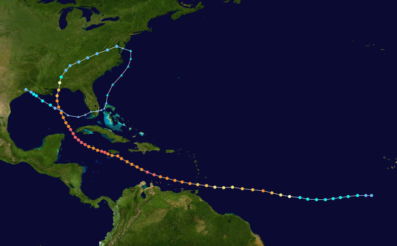
English: Track map of Hurricane Ivan of the 2004 Atlantic hurricane season. The points show the location of the storm at 6-hour intervals. The colour represents the storm's maximum sustained wind speeds as classified in the (see below), and the shape of the data points represent the nature of the storm, according to the legend below. Tropical depression (≤38 mph, ≤62 km/h)
Tropical storm (39–73 mph, 63–118 km/h)
Category 1 (74–95 mph, 119–153 km/h)
Category 2 (96–110 mph, 154–177 km/h)
Category 3 (111–129 mph, 178–208 km/h)
Category 4 (130–156 mph, 209–251 km/h)
Category 5 (≥157 mph, ≥252 km/h)
Unknown
Storm type |
||
| Date | 2004-09-02–2004-09-24 | ||
| Source | Created by Supportstorm using Wikipedia:WikiProject Tropical cyclones/Tracks. The background image is from NASA. Tracking data is from the National Hurricane Center[1]. | ||
| Auteur | Supportstorm | ||
| Source code | Track map data table, if present below, is in HURDAT2 or ATCF format. See format details in [2] and [3], respectively.
|
Conditions d’utilisation[modifier]
| Cette œuvre a été placée dans le domaine public par son auteur, Supportstorm. Ceci s’applique dans le monde entier. Dans certains pays, ceci peut ne pas être possible ; dans ce cas : Supportstorm accorde à toute personne le droit d’utiliser cette œuvre dans n’importe quel but, sans aucune condition, sauf celles requises par la loi. |
Historique du fichier
Cliquer sur une date et heure pour voir le fichier tel qu'il était à ce moment-là.
| Date et heure | Vignette | Dimensions | Utilisateur | Commentaire | |
|---|---|---|---|---|---|
| actuel | 28 février 2024 à 18:28 | | 2 700 × 1 669 (1,98 Mio) | 2003 LN6 (d | contributions) | Reverted to version as of 06:45, 7 January 2020 (UTC) |
| 3 juin 2023 à 14:31 |  | 2 700 × 1 669 (2 Mio) | Phinww (d | contributions) | Updated to new colour standards | |
| 7 janvier 2020 à 06:45 |  | 2 700 × 1 669 (1,98 Mio) | Supportstorm (d | contributions) | 2700 px | |
| 13 juillet 2006 à 00:38 |  | 1 024 × 633 (384 kio) | Nilfanion (d | contributions) | ||
| 10 juillet 2006 à 21:47 |  | 1 024 × 633 (383 kio) | Nilfanion (d | contributions) | {{Hurricane auto track map|Hurricane Ivan (2004)}} | |
| 12 novembre 2005 à 01:50 |  | 1 024 × 633 (385 kio) | Jdorje~commonswiki (d | contributions) | {{Hurricane auto track map|Hurricane Ivan (2004)}} |
Vous ne pouvez pas remplacer ce fichier.
Utilisations locales du fichier
Les 2 pages suivantes utilisent ce fichier :
.png)
Utilisations du fichier sur d’autres wikis
Les autres wikis suivants utilisent ce fichier :
- Utilisation sur ar.wikipedia.org
- Utilisation sur de.wikipedia.org
- Utilisation sur en.wikipedia.org
- Talk:List of Category 5 Atlantic hurricanes/old version
- Portal:Tropical cyclones/Featured article/Meteorological History of Hurricane Ivan
- User:Alex1996Ne/Hurricane Paths
- Talk:Port Charlotte High School
- User:LightandDark2000/My Notable Storms
- User:Wxtrackercody/2004 Atlantic hurricane season
- Wikipedia talk:WikiProject Weather/Colour discussions
- Utilisation sur es.wikipedia.org
- Utilisation sur fi.wikipedia.org
- Utilisation sur fr.wikipedia.org
- Utilisation sur hu.wikipedia.org
- Utilisation sur ja.wikipedia.org
- Utilisation sur lv.wikipedia.org
- Utilisation sur nl.wikipedia.org
- Utilisation sur pl.wikipedia.org
- Utilisation sur pt.wikipedia.org
- Utilisation sur ru.wikipedia.org
- Utilisation sur simple.wikipedia.org
- Utilisation sur sv.wikipedia.org
- Utilisation sur tl.wikipedia.org
- Utilisation sur zh.wikipedia.org