File:J. H. Colton's map of the state of Louisiana and eastern part of Texas compiled from United States Surveys, and other authentic sources, showing the counties, townships, sections. Fractional sections, LOC 98688488.jpg
Jump to navigation
Jump to search

Size of this preview: 764 × 599 pixels. Other resolutions: 306 × 240 pixels | 612 × 480 pixels | 979 × 768 pixels | 1,280 × 1,004 pixels | 2,560 × 2,009 pixels | 13,072 × 10,256 pixels.
Original file (13,072 × 10,256 pixels, file size: 27.76 MB, MIME type: image/jpeg)
Captions
Captions
Add a one-line explanation of what this file represents
Summary
[edit]| Warning | The original file is very high-resolution. It might not load properly or could cause your browser to freeze when opened at full size. |
|---|
| Description |
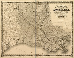
English: Shows drainage, cities and towns, township and county boundaries, and the railroad network. |
||
| Title | J. H. Colton's map of the state of Louisiana and eastern part of Texas compiled from United States Surveys, and other authentic sources, showing the counties, townships, sections. Fractional sections, settlement rights, railroads, &c. | ||
| Shelf ID | G4010 1863 .C6 | ||
| Date | |||
| Source | https://www.loc.gov/item/98688488/ | ||
| Author | Colton, J. H. (Joseph Hutchins); Colton, J. H. | ||
| Permission (Reusing this file) |
|
||
| Other versions |
|
||
| Location | United States · Louisiana | ||
| Part of | American Memory · Catalog · Railroad Maps, 1828-1900 · Geography And Map Division · Transportation And Communication | ||
| Subject | United States · Maps · Louisiana |


Licensing
[edit]
|
This is a faithful photographic reproduction of a two-dimensional, public domain work of art. The work of art itself is in the public domain for the following reason:
The official position taken by the Wikimedia Foundation is that "faithful reproductions of two-dimensional public domain works of art are public domain".
This photographic reproduction is therefore also considered to be in the public domain in the United States. In other jurisdictions, re-use of this content may be restricted; see Reuse of PD-Art photographs for details. | ||||
File history
Click on a date/time to view the file as it appeared at that time.
| Date/Time | Thumbnail | Dimensions | User | Comment | |
|---|---|---|---|---|---|
| current | 07:07, 7 June 2018 | | 13,072 × 10,256 (27.76 MB) | Fæ (talk | contribs) | LOC Maps https://www.loc.gov/item/98688488/ #7363 |
You cannot overwrite this file.
File usage on Commons
The following page uses this file: