File:Julius Raab monument, synchronous finger-pointing.jpg
Original file (4,774 × 3,169 pixels, file size: 5.75 MB, MIME type: image/jpeg)
Captions
Summary
[edit]DescriptionJulius Raab monument, synchronous finger-pointing.jpg |
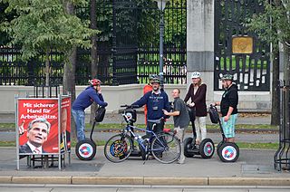
Deutsch: Julius-Raab-Denkmal am Volksgarten in Wien, davor am Ringradweg Segwayfahrer die nach dem Weg fragen. Synchrones Zeigen mit dem Zeigefinger durch Faymann und einem hilfreichen Radfahrer. English: Julius Raab monument at the Volksgarten in Vienna. In front some Segway drivers having lost their way on the Ring Radweg. Synchronous finger-pointing of Faymann and local bicycle driver. |
Date | |
Source | Own work |
Author | Herzi Pinki |
Camera location | 48° 12′ 28.92″ N, 16° 21′ 34.36″ E | View this and other nearby images on: OpenStreetMap | 48.208033; 16.359545 |
---|
Licensing
[edit]- You are free:
- to share – to copy, distribute and transmit the work
- to remix – to adapt the work
- Under the following conditions:
- attribution – You must give appropriate credit, provide a link to the license, and indicate if changes were made. You may do so in any reasonable manner, but not in any way that suggests the licensor endorses you or your use.
- share alike – If you remix, transform, or build upon the material, you must distribute your contributions under the same or compatible license as the original.
This image was uploaded as part of Wiki Loves Monuments 2013.
Afrikaans ∙ Alemannisch ∙ العربية ∙ جازايرية ∙ azərbaycanca ∙ Bikol Central ∙ беларуская ∙ беларуская (тарашкевіца) ∙ български ∙ বাংলা ∙ brezhoneg ∙ bosanski ∙ català ∙ čeština ∙ Cymraeg ∙ dansk ∙ Deutsch ∙ Zazaki ∙ Ελληνικά ∙ English ∙ Esperanto ∙ español ∙ eesti ∙ euskara ∙ فارسی ∙ suomi ∙ français ∙ Frysk ∙ Gaeilge ∙ galego ∙ עברית ∙ हिन्दी ∙ hrvatski ∙ magyar ∙ հայերեն ∙ Bahasa Indonesia ∙ Ido ∙ italiano ∙ 日本語 ∙ ქართული ∙ 한국어 ∙ кыргызча ∙ Lëtzebuergesch ∙ latviešu ∙ Malagasy ∙ македонски ∙ മലയാളം ∙ Bahasa Melayu ∙ Malti ∙ norsk bokmål ∙ नेपाली ∙ Nederlands ∙ norsk nynorsk ∙ norsk ∙ polski ∙ português ∙ português do Brasil ∙ română ∙ русский ∙ sicilianu ∙ davvisámegiella ∙ slovenčina ∙ slovenščina ∙ shqip ∙ српски / srpski ∙ svenska ∙ ไทย ∙ Tagalog ∙ Türkçe ∙ українська ∙ اردو ∙ oʻzbekcha / ўзбекча ∙ Yorùbá ∙ 中文 ∙ 中文(中国大陆) ∙ 中文(简体) ∙ 中文(繁體) ∙ 中文(香港) ∙ 中文(臺灣) ∙ +/− |
Annotations InfoField | This image is annotated: View the annotations at Commons |
Finger
Finger
File history
Click on a date/time to view the file as it appeared at that time.
Date/Time | Thumbnail | Dimensions | User | Comment | |
---|---|---|---|---|---|
current | 20:41, 17 September 2013 | 4,774 × 3,169 (5.75 MB) | Herzi Pinki (talk | contribs) | User created page with UploadWizard |
You cannot overwrite this file.
File usage on Commons
There are no pages that use this file.
Metadata
This file contains additional information such as Exif metadata which may have been added by the digital camera, scanner, or software program used to create or digitize it. If the file has been modified from its original state, some details such as the timestamp may not fully reflect those of the original file. The timestamp is only as accurate as the clock in the camera, and it may be completely wrong.
Camera manufacturer | NIKON CORPORATION |
---|---|
Camera model | NIKON D7000 |
Author | Christian Philipp |
Copyright holder |
|
Exposure time | 1/125 sec (0.008) |
F-number | f/5.6 |
ISO speed rating | 200 |
Date and time of data generation | 11:32, 1 September 2013 |
Lens focal length | 130 mm |
Latitude | 48° 12′ 28.92″ N |
Longitude | 16° 21′ 34.36″ E |
Altitude | 186 meters above sea level |
Usage terms |
|
Label | Zyan |
Orientation | Normal |
Horizontal resolution | 300 dpi |
Vertical resolution | 300 dpi |
Software used | ViewNX 2.0 M |
File change date and time | 22:32, 17 September 2013 |
Y and C positioning | Centered |
Pair of black and white reference values |
|
Exposure Program | Shutter priority |
Exif version | 2.3 |
Date and time of digitizing | 11:32, 1 September 2013 |
Meaning of each component |
|
APEX exposure bias | −0.33333333333333 |
Maximum land aperture | 5 APEX (f/5.66) |
Metering mode | Pattern |
Light source | Unknown |
Flash | Flash did not fire, compulsory flash suppression |
DateTime subseconds | 10 |
DateTimeOriginal subseconds | 10 |
DateTimeDigitized subseconds | 10 |
Supported Flashpix version | 1 |
Color space | Uncalibrated |
Sensing method | One-chip color area sensor |
File source | Digital still camera |
Scene type | A directly photographed image |
Custom image processing | Normal process |
Exposure mode | Auto exposure |
White balance | Auto white balance |
Digital zoom ratio | 1 |
Focal length in 35 mm film | 195 mm |
Scene capture type | Standard |
Scene control | None |
Contrast | Normal |
Saturation | Normal |
Sharpness | Normal |
Subject distance range | Unknown |
GPS time (atomic clock) | 09:32 |
Satellites used for measurement | 04 |
Geodetic survey data used | WGS 84 |
GPS date | 1 September 2013 |
GPS tag version | 0.0.3.2 |
Urgency | 5 |
Structured data
Items portrayed in this file
depicts
1 September 2013
48°12'28.91999"N, 16°21'34.36200"E
6,032,452 byte
3,169 pixel
4,774 pixel
image/jpeg
6d4d71ce71b33d51725b0194c4bdaaeb415f69e8
0.008 second
5.6
200
130 millimetre
- Cultural heritage monuments in Austria with known IDs
- CC-BY-SA-3.0-AT
- Self-published work
- Images from Wiki Loves Monuments 2013
- Images from Wiki Loves Monuments 2013 in Austria
- Cultural heritage monuments in Austria check done
- Uploaded via Campaign:wlm-at
- Images with annotations
- Images by Herzi Pinki
- Images by Herzi Pinki/funny
- Austria photographs taken on 2013-09-01