File:KAARTEN SGD - Nieuwe groepering van landbouwgebieden in Nederland in 14 groepen.jpeg
Jump to navigation
Jump to search

Size of this preview: 434 × 600 pixels. Other resolutions: 174 × 240 pixels | 347 × 480 pixels | 556 × 768 pixels | 1,162 × 1,606 pixels.
Original file (1,162 × 1,606 pixels, file size: 233 KB, MIME type: image/jpeg)
Captions
Captions
Add a one-line explanation of what this file represents
Summary
[edit]| Title |
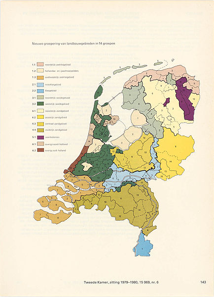
KAARTEN SGD - Nieuwe groepering van landbouwgebieden in Nederland in 14 groepen |
||||||||||||||||||||||||||
| Description |
Behoort bij bijlage E van het wetsontwerp Vervreemding landbouwgronden |
||||||||||||||||||||||||||
| Date | |||||||||||||||||||||||||||
| Source |
This image in context: http://www.statengeneraaldigitaal.nl/document?id=sgd:mpeg21:19791980:0006661&pagina=143;
|
||||||||||||||||||||||||||
| Creator |
English: The individual creators of this map are unknown, it was commissioned by the House of Representatives of the Netherlands.
Nederlands: De precieze makers van deze kaart zijn niet bekend, hij werd in opdracht van de Tweede Kamer der Staten-Generaal gemaakt. |
||||||||||||||||||||||||||
| Permission (Reusing this file) |
|
||||||||||||||||||||||||||
| Geotemporal data | |||||||||||||||||||||||||||
| Date depicted | |||||||||||||||||||||||||||
| Map location | Nederland | ||||||||||||||||||||||||||
| Scale | ca. 1:1.750.000 | ||||||||||||||||||||||||||
| Bounding box |
|
||||||||||||||||||||||||||
| Georeferencing | If inappropriate please set warp_status = skip to hide. | ||||||||||||||||||||||||||
| Bibliographic data | |||||||||||||||||||||||||||
| Publisher |
This map was commissioned and published by the
|
||||||||||||||||||||||||||
| Archival data | |||||||||||||||||||||||||||
| Collection |
This map was digitized by the
|
||||||||||||||||||||||||||
| Notes |
Nederlands: agrarische regio's |
||||||||||||||||||||||||||


File history
Click on a date/time to view the file as it appeared at that time.
| Date/Time | Thumbnail | Dimensions | User | Comment | |
|---|---|---|---|---|---|
| current | 05:24, 16 November 2015 | | 1,162 × 1,606 (233 KB) | OlafJanssen (talk | contribs) | GWToolset: Creating mediafile for OlafJanssen. |
You cannot overwrite this file.
File usage on Commons
There are no pages that use this file.
File usage on other wikis
The following other wikis use this file:
- Usage on nl.wikipedia.org