File:KMYF - FAA Airport Diagram.svg
Jump to navigation
Jump to search

Size of this PNG preview of this SVG file: 390 × 599 pixels. Other resolutions: 156 × 240 pixels | 312 × 480 pixels | 500 × 768 pixels | 667 × 1,024 pixels | 1,334 × 2,048 pixels | 512 × 786 pixels.
Original file (SVG file, nominally 512 × 786 pixels, file size: 992 KB)
Captions
Captions
Add a one-line explanation of what this file represents
Summary[edit]
| Description |
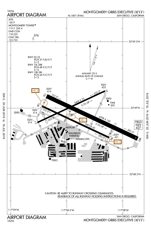
English: Airport diagram for Montgomery-Gibbs Executive Airport in San Diego, California, United States. |
| Date | 20 June 2019 to 18 July 2019 |
| Source | Federal Aviation Administration |
| Author | National Aeronautical Charting Office |
Licensing[edit]
This image or file is a work of a Federal Aviation Administration employee, taken or made as part of that person's official duties. As a work of the U.S. federal government, the image is in the public domain in the United States.
|
 |
File history
Click on a date/time to view the file as it appeared at that time.
| Date/Time | Thumbnail | Dimensions | User | Comment | |
|---|---|---|---|---|---|
| current | 20:04, 25 June 2019 | | 512 × 786 (992 KB) | Sharper (talk | contribs) | - |
| 20:02, 25 June 2019 |  | 512 × 786 (422 KB) | Sharper (talk | contribs) | - | |
| 19:55, 25 June 2019 |  | 512 × 786 (422 KB) | Sharper (talk | contribs) | User created page with UploadWizard |
You cannot overwrite this file.
File usage on Commons
The following 4 pages use this file:
File usage on other wikis
The following other wikis use this file:
- Usage on en.wikipedia.org