File:KOZAKS of the BLACK SEA on the MAP of 1806.JPG
Jump to navigation
Jump to search

Size of this preview: 800 × 600 pixels. Other resolutions: 320 × 240 pixels | 640 × 480 pixels | 1,024 × 768 pixels | 1,280 × 960 pixels | 2,592 × 1,944 pixels.
Original file (2,592 × 1,944 pixels, file size: 1.85 MB, MIME type: image/jpeg)
Captions
Captions
Add a one-line explanation of what this file represents
Summary
[edit]
| Description |
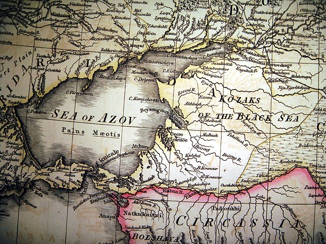
English: Abstract from map «The Russian Dominions in Europe», drawn from the latest maps, printed by the Academy of Since St. Petersburg, revised and corrected with the Post Roads & New Governments from the Russian Atlas of 1806 by Gaspar Nantiat, London, published by W. Faden, Geographer to His Majesty and his Royal Highness, the Prince of Wales, Charing Cross, June 4th 1808.
Русский: Фрагмент карты «Доминионы России в Европе» с землями «Войска черноморских казаков» (впоследствии «Кубанским войском»), изданной по последним рисункам и картам Академии Наук в Санкт Петербурге и откорректированной с нанесением почтовых трактов и новых администраций из русского атласа 1806 года Гаспером Нантэйном. Лондон. Отпечатано картографом Его Величества и Его Королевского Высотчества принца Уэльского У. Фэйденом. Чэринь Кросс. 4 июня 1808 года. |
| Date | |
| Source | Own work |
| Author | HOBOPOCC |
Licensing
[edit]
I, the copyright holder of this work, hereby publish it under the following licenses:
This file is licensed under the Creative Commons Attribution-Share Alike 3.0 Unported license.
- You are free:
- to share – to copy, distribute and transmit the work
- to remix – to adapt the work
- Under the following conditions:
- attribution – You must give appropriate credit, provide a link to the license, and indicate if changes were made. You may do so in any reasonable manner, but not in any way that suggests the licensor endorses you or your use.
- share alike – If you remix, transform, or build upon the material, you must distribute your contributions under the same or compatible license as the original.

|
Permission is granted to copy, distribute and/or modify this document under the terms of the GNU Free Documentation License, Version 1.2 or any later version published by the Free Software Foundation; with no Invariant Sections, no Front-Cover Texts, and no Back-Cover Texts. A copy of the license is included in the section entitled GNU Free Documentation License. |
You may select the license of your choice.
File history
Click on a date/time to view the file as it appeared at that time.
| Date/Time | Thumbnail | Dimensions | User | Comment | |
|---|---|---|---|---|---|
| current | 12:36, 11 August 2018 | | 2,592 × 1,944 (1.85 MB) | 1970gemini (talk | contribs) | fiat lux |
| 13:19, 19 March 2010 |  | 2,592 × 1,944 (2.22 MB) | HOBOPOCC (talk | contribs) | {{Information |Description={{en|1=Abstract from map «The Russian Dominions in Europe», drawn from the latest maps, printed by the Academy of Since St. Petersburg, revised and corrected with the Post Roads & New Governments from the Russian Atlas of 1806 |
You cannot overwrite this file.
File usage on Commons
There are no pages that use this file.
File usage on other wikis
The following other wikis use this file:
- Usage on ar.wikipedia.org
- Usage on ca.wikipedia.org
- Usage on de.wikipedia.org
- Usage on en.wikipedia.org
- Usage on es.wikipedia.org
- Usage on lv.wikipedia.org
- Usage on pt.wikipedia.org
- Usage on ru.wikipedia.org
- Usage on tr.wikipedia.org
- Usage on uk.wikipedia.org