File:Kaart van de Vliet 1556, C. Oelensz., SA Delft, inv.nr. 119503.tif

Original file (11,230 × 2,632 pixels, file size: 84.59 MB, MIME type: image/tiff)
Captions
Captions
Summary
[edit]| Description |
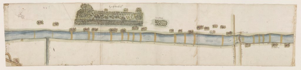
Nederlands: Kaart van de Vliet, gemaakt in het kader van een conflict dat in 1556 speelde voor de heemraden van Rijnland. Het ging tussen Leiden en de ambachten langs de Vliet, met als onderwerp de bevaarbaarheid van de Vliet. Op de kaart zijn de zogenaamde ‘wedden’ (doorwaardbare plaatsen) en de diepten aangegeven. (kaartdeel 3 deel van de Vliet, met het Schakenbos en rechts het Quakelbruggetje)
-vanaf links aan onderzijde: de Sijtwin de groene sloet na Soetermeer den rijwech off den hofwech en ganck pat het huis ten Roij -aan bovenzijde: het tScakenbus het oestbus de QuakelbrucgheEnglish: Map of the en:Vliet, made in the context of a conflict that played for the congregations of Rijnland in 1556. It went between Leiden and the crafts along the Vliet, with the navigability of the Vliet as its subject. On the map the so-called "bets" (eligible places) and depths are indicated. (map part 3 part of the Vliet, with the Schakenbos and on the right the Quakelbruggetje)
-from the left at the bottom: the Sijtwin the green slob after Soetermeer the riding off the court and ganck pat the house ten Roij -at top: the tScakenbus the oyster the Quakelbrucghe |
||||||||||||||||||||
| Date | |||||||||||||||||||||
| Source | Stadsarchief Delft, archief Eerste Afdeling, inv.nr. 3552 (voorheen 916). | ||||||||||||||||||||
| Creator |
Coenraet Oelensz. |
||||||||||||||||||||
| Geotemporal data | |||||||||||||||||||||
| Date depicted | |||||||||||||||||||||
| Georeferencing | If inappropriate please set warp_status = skip to hide. | ||||||||||||||||||||
| Archival data | |||||||||||||||||||||
| Collection |
|
||||||||||||||||||||
| Accession number |
119503 |
||||||||||||||||||||
| Dimensions | height: 21 cm (8.2 in); width: 90 cm (35.4 in) | ||||||||||||||||||||
| Other versions |
|
||||||||||||||||||||

Licensing
[edit]|
This work is in the public domain in its country of origin and other countries and areas where the copyright term is the author's life plus 70 years or fewer. This work is in the public domain in the United States because it was published (or registered with the U.S. Copyright Office) before January 1, 1929. | |
| This file has been identified as being free of known restrictions under copyright law, including all related and neighboring rights. | |
File history
Click on a date/time to view the file as it appeared at that time.
| Date/Time | Thumbnail | Dimensions | User | Comment | |
|---|---|---|---|---|---|
| current | 11:10, 15 April 2020 | 11,230 × 2,632 (84.59 MB) | Beeld&Geluid Stadsarchief Delft (talk | contribs) | Uploaded a work by Coenraet Oelensz. from Stadsarchief Delft, archief Eerste Afdeling, inv.nr. 3552 (voorheen 916). with UploadWizard |
You cannot overwrite this file.
File usage on Commons
The following 6 pages use this file:
- Commons:Graphic Lab/Map workshop/Archive/2020
- File:Kaart van de Vliet 1556, C. Oelensz., SA Delft, inv.nr. 119501.tif
- File:Kaart van de Vliet 1556, C. Oelensz., SA Delft, inv.nr. 119502.tif
- File:Kaart van de Vliet 1556, C. Oelensz., SA Delft, inv.nr. 119504.tif
- File:Kaart van de Vliet 1556, C. Oelensz., SA Delft, inv.nr. 119505.tif
- File:Stitch Guide for Kaart van de Vliet Kaart van de Vliet 1556, C. Oelensz., SA Delft.png
File usage on other wikis
The following other wikis use this file:
- Usage on nl.wikipedia.org