File:Kaart van de afdeeling Boutry, Kust van Guinea (1859).jpg
Jump to navigation
Jump to search

Size of this preview: 772 × 599 pixels. Other resolutions: 309 × 240 pixels | 618 × 480 pixels | 989 × 768 pixels | 1,280 × 994 pixels | 2,560 × 1,988 pixels | 4,823 × 3,745 pixels.
Original file (4,823 × 3,745 pixels, file size: 1.36 MB, MIME type: image/jpeg)
Captions
Captions
Add a one-line explanation of what this file represents
Summary
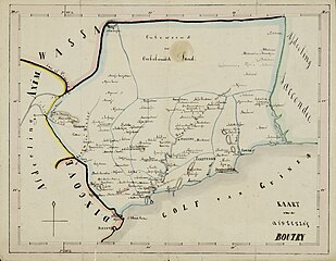
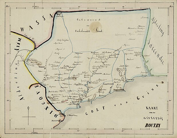
[edit]| Kaart van de afdeeling Boutry, Kust van Guinea.
( |
||||||||||||||||||||||||
|---|---|---|---|---|---|---|---|---|---|---|---|---|---|---|---|---|---|---|---|---|---|---|---|---|
| Artist |
Unknown author |
|||||||||||||||||||||||
| Title |
Kaart van de afdeeling Boutry, Kust van Guinea. |
|||||||||||||||||||||||
| Description |
Map of the district of Boutry on the Dutch Gold Coast |
|||||||||||||||||||||||
| Date | 1859 | |||||||||||||||||||||||
| Collection |
|
|||||||||||||||||||||||
| Accession number |
NL-HaNA, Koloniën / Kaarten en Tekeningen, 4.MIKO, inv.nr. 754 |
|||||||||||||||||||||||
| Source/Photographer | gahetna.nl | |||||||||||||||||||||||

.jpg&action=edit§ion=1)
Licensing
[edit].jpg&action=edit§ion=2)
|
This work is in the public domain in its country of origin and other countries and areas where the copyright term is the author's life plus 100 years or fewer. This work is in the public domain in the United States because it was published (or registered with the U.S. Copyright Office) before January 1, 1929. | |
| This file has been identified as being free of known restrictions under copyright law, including all related and neighboring rights. | |
File history
Click on a date/time to view the file as it appeared at that time.
| Date/Time | Thumbnail | Dimensions | User | Comment | |
|---|---|---|---|---|---|
| current | 11:06, 4 May 2023 | | 4,823 × 3,745 (1.36 MB) | Racconish (talk | contribs) | Cropped 4 % horizontally, 4 % vertically using CropTool with precise mode. |
| 19:59, 18 October 2022 |  | 5,000 × 3,893 (1.56 MB) | Fentener van Vlissingen (talk | contribs) | higher res | |
| 17:50, 23 February 2017 |  | 1,293 × 1,038 (208 KB) | Fentener van Vlissingen (talk | contribs) | {{Artwork |artist = Unknown |author = |title = Kaart van de afdeeling Boutry, Kust van Guinea. |description = Map of the district of Boutry on the Dutch Gold Coast |date = 1859 |medium... |
You cannot overwrite this file.
File usage on Commons
The following page uses this file:
.jpg)
File usage on other wikis
The following other wikis use this file:
- Usage on en.wikipedia.org
- Usage on fr.wikipedia.org
- Usage on ha.wikipedia.org
- Usage on it.wikipedia.org
- Usage on lt.wikipedia.org
.jpg&oldid=759114781)