File:Kafue Flats, Zambia (MODIS 2021-04-05).jpg

Original file (1,234 × 903 pixels, file size: 152 KB, MIME type: image/jpeg)
Captions
Captions
Summary[edit]
.jpg&action=edit§ion=1)
| Description |
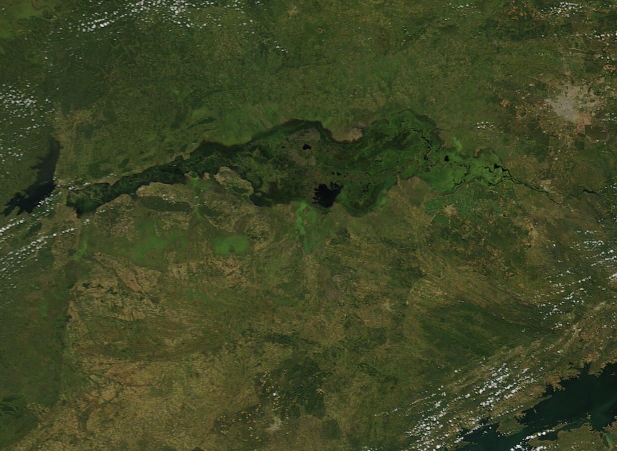
English: The Kafue River rises near the Congo/Zambia border, then meanders roughly 1,600 km (994 mi) across Zambia to eventually join the Zambezi River near Chirundu in Zimbabwe. After leaving Lake Itezhi-tezhi through the Itezhi-tezhi Dam, the Kafue becomes wide and shallow as it passes through the area known as the Kefue Flats. Eventually the waters are confined at a second dam, the Kafue Gorge hydro electric dam.
Kafue Flats is a 6,500 square kilometer (2,510 sq mi) floodplain that was once one of the richest wildlife habitats in Africa, and was subject to heavy seasonal flooding. The rhythm of the seasonal rains followed by the hot, dry season sustained hunting, fishing, livestock grazing, and cropping on the flats. It also created a living habitat that supported over 400 bird species and a wide variety of animals, including the Kafue lechwe (Kobus leche)—a water-loving antelope that has been known to submerge in shallow water when threatened. The Itezhi-tezhi Dam was built, in part, to control flooding in the Flats; however, loss of seasonal floods had wide-ranging and mostly negative impacts on the ecosystem which depends on wet-season flooding to create lush growth of grasses in the dry season. Now the dam releases water to the Flats on a timetable that mimics the more natural seasonal rains, but also minimizes extensive and damaging extreme flood events. The climate of Zambia is marked by three distinct seasons. The cool-dry season runs from early May to August and is followed by the hot dry season from September to October. The wet-warm season begins in November and ends in March. Most of the rain falls between December and February. The dam releases water based on the rainfall each year, but to minimize extreme floods, it releases water as a “freshet”—the amount of water judged to meet the environmental requirement for flooding, flow flux, and recession of the water on the Kafue Flats. In wet years, the freshet may start as early as January, but in a dry year the freshet starts in March. On April 1, 2021, the Moderate Resolution Imaging Spectroradiometer (MODIS) on board NASA’s Terra satellite acquired a true-color image of the Kafue Flats. The lush dark green color of the Flats stand out in contrast to the light greens and tans of the dryer land surrounding the recently flooded area. |
||
| Date | Taken on 1 April 2021 | ||
| Source |
Kafue Flats, Zambia (direct link)
|
||
| Author | MODIS Land Rapid Response Team, NASA GSFC |
| This media is a product of the Terra mission Credit and attribution belongs to the mission team, if not already specified in the "author" row |
Licensing[edit]
.jpg&action=edit§ion=2)
| This file is in the public domain in the United States because it was solely created by NASA. NASA copyright policy states that "NASA material is not protected by copyright unless noted". (See Template:PD-USGov, NASA copyright policy page or JPL Image Use Policy.) | ||
 |
Warnings:
|
File history
Click on a date/time to view the file as it appeared at that time.
| Date/Time | Thumbnail | Dimensions | User | Comment | |
|---|---|---|---|---|---|
| current | 17:54, 30 January 2024 | | 1,234 × 903 (152 KB) | OptimusPrimeBot (talk | contribs) | #Spacemedia - Upload of http://modis.gsfc.nasa.gov/gallery/images/image04052021_250m.jpg via Commons:Spacemedia |
You cannot overwrite this file.
File usage on Commons
There are no pages that use this file.
.jpg&oldid=847258261)