File:Karte Aut Stmk HF.png
Jump to navigation
Jump to search

Size of this preview: 800 × 560 pixels. Other resolutions: 320 × 224 pixels | 640 × 448 pixels | 1,000 × 700 pixels.
Original file (1,000 × 700 pixels, file size: 98 KB, MIME type: image/png)
Captions
Captions
Add a one-line explanation of what this file represents
Summary
[edit]
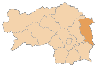
| Description | Karte: politischer de:Bezirk Hartberg-Fürstenfeld |
| Date | (UTC) |
| Source |
This file was derived from: Karte Aut Stmk ohne.png: |
| Author | Kontrollstelle Kundl |
Licensing
[edit]
I, the copyright holder of this work, hereby publish it under the following licenses:
| This file is licensed under the Creative Commons Attribution-Share Alike 3.0 Unported license. | ||
| ||
| This licensing tag was added to this file as part of the GFDL licensing update. |

|
Permission is granted to copy, distribute and/or modify this document under the terms of the GNU Free Documentation License, Version 1.2 or any later version published by the Free Software Foundation; with no Invariant Sections, no Front-Cover Texts, and no Back-Cover Texts. A copy of the license is included in the section entitled GNU Free Documentation License. |
You may select the license of your choice.
Original upload log
[edit]
This image is a derivative work of the following image:
- Karte_Aut_Stmk_HB.png licensed with Cc-by-sa-3.0-migrated, GFDL; derivative work: Gugganij (Uploaded with derivativeFX The original uploader was Plp at German Wikipedia.)
| This is a retouched picture, which means that it has been digitally altered from its original version. Modifications: Bezirkszusammenlegungen 2013. The original can be viewed here: Karte Aut Stmk HB.png:
|
- 2012-03-24T13:29:35Z Kontrollstellekundl 300x209 (4868 Bytes) JU + KF = MT, 01.01.2012
- 2007-01-02T08:42:27Z Wigulf 300x209 (3924 Bytes) Source: de.wikipedia Map made by [[:de:Benutzer:plp]] {{GNU FDL}} [[Category:Maps of Styria]]
File history
Click on a date/time to view the file as it appeared at that time.
| Date/Time | Thumbnail | Dimensions | User | Comment | |
|---|---|---|---|---|---|
| current | 21:38, 11 January 2020 | | 1,000 × 700 (98 KB) | Kontrollstellekundl (talk | contribs) | actual 01.01.2020 |
| 18:15, 3 January 2015 |  | 1,000 × 700 (97 KB) | Kontrollstellekundl (talk | contribs) | actual 01.01.2015 | |
| 17:28, 1 January 2013 |  | 300 × 209 (3 KB) | Gugganij (talk | contribs) | == {{int:filedesc}} == {{Information |Description=Karte: politischer de:Bezirk Hartberg-Fürstenfeld * Lizenz: de:GNU FDL * Quelle: Zeichnung plp * Datum: de:2013 |Source={{Derived from|Karte_Aut_Stmk_HB.png|display=... |
You cannot overwrite this file.
File usage on Commons
There are no pages that use this file.
File usage on other wikis
The following other wikis use this file:
- Usage on bs.wikipedia.org
- Usage on ce.wikipedia.org
- Айхберг (Штири)
- Альтенмаркт-бай-Фуьрстенфельд
- Бад-Блумау
- Бад-Вальтерсдорф
- Блайндорф
- Бургау (Штири)
- Бух-Гайзельдорф
- Венигцелль
- Воьрт-ан-дер-Лафниц
- Грайнбах
- Графендорф-бай-Хартберг
- Гросвильферсдорф
- Гросхарт
- Гросштайнбах
- Дехантскирхен
- Динерсдорф
- Зайфен-Боден
- Зоьхау
- Зоннхофен
- Иберсбах
- Ильц (Штири)
- Кайбинг
- Кайндорф (Хартберг)
- Лафниц (Штири)
- Лимбах-бай-Нойдау
- Лойперсдорф-бай-Фуьрстенфельд
- Нестельбах-им-Ильцталь
- Нойдау
- Оттендорф-ан-дер-Ритшайн
- Поьллау (Штири)
- Поьллауберг
- Пинггау
- Пухег
- Рабенвальд
- Санкт-Иоганн-бай-Херберштайн
- Форау
- Форнхольц
- Фридберг (Штири)
- Фуьрстенфельд
- Хайнерсдорф
- Хартберг
- Хартберг-Умгебунг
- Хартль (Штири)
- Хофкирхен-бай-Хартберг
- Шахен-бай-Форау
- Штайн (Фуьрстенфельд)
- Штубенберг-ам-Зе
- Эберсдорф (Штири)
- Кеп:Австри:Хартберг-Фуьрстенфельд гуо:ГӀаланаш
View more global usage of this file.