File:Karte Eines Theils von Africa zur Übersicht von Dr. Bath's Reisen, 1850-1855 und der von ihm Gesammelten Itinerarien - Westiches-Östliches Blatt - Entworfen u. Gezeichnet v. A. Petermann - btv1b53179768g.jpg
Jump to navigation
Jump to search

Size of this preview: 800 × 591 pixels. Other resolutions: 320 × 236 pixels | 640 × 473 pixels | 1,024 × 757 pixels | 1,280 × 946 pixels | 2,560 × 1,892 pixels | 11,466 × 8,474 pixels.
Original file (11,466 × 8,474 pixels, file size: 9.54 MB, MIME type: image/jpeg)
Captions
Captions
Add a one-line explanation of what this file represents
Summary
[edit]| Warning | The original file is very high-resolution. It might not load properly or could cause your browser to freeze when opened at full size. |
|---|
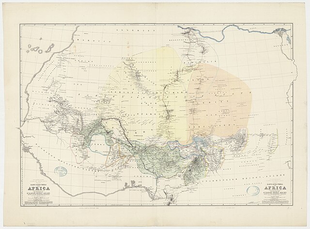
| Karte Eines Theils von Africa zur Übersicht von Dr. Bath's Reisen, 1850-1855 und der von ihm Gesammelten Itinerarien : Westiches-Östliches Blatt / Entworfen u. Gezeichnet v. A. Petermann
( |
|||||||||||||||||||||||||||
|---|---|---|---|---|---|---|---|---|---|---|---|---|---|---|---|---|---|---|---|---|---|---|---|---|---|---|---|
| Author |
Petermann, August Heinrich (1822-1878). Cartographe Barth, Heinrich (1821-1865). Auteur du texte Klett- Perthes Verlag. Éditeur scientifique |
||||||||||||||||||||||||||
| Title |
Karte Eines Theils von Africa zur Übersicht von Dr. Bath's Reisen, 1850-1855 und der von ihm Gesammelten Itinerarien : Westiches-Östliches Blatt / Entworfen u. Gezeichnet v. A. Petermann |
||||||||||||||||||||||||||
| Description |
Français : Sujet : Voyageurs
Divisions politiques et administratives Itinéraires Afrique -- Centre-Ouest Échelle(s) : 1:6 000 000 Couverture : Afrique occidentale Afrique orientale Langue : allemand Éditeur : Justus Perthes (Gotha) |
||||||||||||||||||||||||||
| Date | 1858 | ||||||||||||||||||||||||||
| Dimensions | height: 95 cm (37.4 in); width: 71 cm (27.9 in) | ||||||||||||||||||||||||||
| Collection |
|
||||||||||||||||||||||||||
| References |
Français : Notice de recueil : http://catalogue.bnf.fr/ark:/12148/cb45106224b
Appartient à : [Division 28 du portefeuille 1 QUATER du Service hydrographique de la marine consacrée au Sahara et régions centrales de l'Afrique] ; 5 Notice du catalogue : http://catalogue.bnf.fr/ark:/12148/cb45556851m |
||||||||||||||||||||||||||
| Source/Photographer |
Français : Bibliothèque nationale de France, département Cartes et plans, GE SH 19 PF 1 QUATER DIV 28 P 5
Bibliothèque nationale de France |
||||||||||||||||||||||||||
| Permission (Reusing this file) |
|
||||||||||||||||||||||||||

File history
Click on a date/time to view the file as it appeared at that time.
| Date/Time | Thumbnail | Dimensions | User | Comment | |
|---|---|---|---|---|---|
| current | 14:08, 15 August 2022 | | 11,466 × 8,474 (9.54 MB) | Gzen92Bot (talk | contribs) | Gallica btv1b53179768g |
You cannot overwrite this file.
File usage on Commons
The following page uses this file: