File:Karte Herzogtum Bayern im 10. Jahrhundert.png
Naviqasiyaya keç
Axtarışa keç

Sınaq göstərişi ölçüsü: 567 × 600 piksel. Digər ölçülər: 227 × 240 piksel | 454 × 480 piksel | 726 × 768 piksel | 968 × 1.024 piksel | 1.936 × 2.048 piksel | 2.844 × 3.008 piksel.
Faylın orijinalı (2.844 × 3.008 piksel, fayl həcmi: 13,67 MB, MIME növü: image/png)
Captions
Captions
Add a one-line explanation of what this file represents

| İzah |
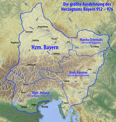
Deutsch: Karte des Herzogtums Bayern im 10. Jahrhundert |
| Tarix | see file history |
| Mənbə |
Öz işi, using
|
| Müəllif | Maximilian Dörrbecker (Chumwa) |
| İcazə (Faylın təkrar istifadəsi) |
I, the copyright holder of this work, hereby publish it under the following license: Bu fayl Creative Commons Attribution-Share Alike 3.0 Unported lisenziyası altında yayımlanır.
Sie dürfen das Bild zu den folgenden Bedingungen nutzen:
|
| Digər versiyalar |
|


|
This image could be re-created using vector graphics as an SVG file. This has several advantages; see Commons:Media for cleanup for more information. If an SVG form of this image is available, please upload it and afterwards replace this template with
{{vector version available|new image name}}.
It is recommended to name the SVG file “Karte Herzogtum Bayern im 10. Jahrhundert.svg”—then the template Vector version available (or Vva) does not need the new image name parameter. |

|
Bu xəritə alman Kartenwerkstatt tərəfindən yaxşılaşdırılmışdir. Siz həmçinin tələb olunan digər xəritələri də təklif edə bilərsiniz.
|
Faylın tarixçəsi
Faylın əvvəlki versiyasını görmək üçün gün/tarix bölməsindəki tarixlərə klikləyin.
| Tarix/Vaxt | Kiçik şəkil | Ölçülər | İstifadəçi | Şərh | |
|---|---|---|---|---|---|
| indiki | 07:53, 13 iyun 2020 | | 2.844 × 3.008 (13,67 MB) | Chumwa (müzakirə | töhfələr) | corr |
| 04:14, 10 iyun 2015 |  | 2.844 × 3.008 (13,67 MB) | Chumwa (müzakirə | töhfələr) | ||
| 07:31, 6 iyun 2015 |  | 2.844 × 3.008 (13,66 MB) | Chumwa (müzakirə | töhfələr) | Hervorhebung andersherum | |
| 07:19, 6 iyun 2015 |  | 2.844 × 3.008 (13,07 MB) | Chumwa (müzakirə | töhfələr) | {{Information |Description= {{de|Karte des Herzogtums Bayern im 10. Jahrhundert}} |Source={{Own}}, using * information from this map by {{U|Electionworld}} * map data from [http://www.maps-for-free.com/ maps-for-free.com]... |
Siz bu faylı yenidən yükləyə bilməzsiniz.
Fayl keçidləri
Aşağıdakı 4 səhifə bu faylı istifadə edir:
Faylın qlobal istifadəsi
Bu fayl aşağıdakı vikilərdə istifadə olunur:
- arz.wikipedia.org layihəsində istifadəsi
- ast.wikipedia.org layihəsində istifadəsi
- azb.wikipedia.org layihəsində istifadəsi
- az.wikipedia.org layihəsində istifadəsi
- ba.wikipedia.org layihəsində istifadəsi
- be.wikipedia.org layihəsində istifadəsi
- bg.wikipedia.org layihəsində istifadəsi
- bs.wikipedia.org layihəsində istifadəsi
- ca.wikipedia.org layihəsində istifadəsi
- cs.wikipedia.org layihəsində istifadəsi
- da.wikipedia.org layihəsində istifadəsi
- de.wikipedia.org layihəsində istifadəsi
- Niederösterreich
- Geschichte Österreichs
- Arnulf I. (Bayern)
- Geschichte Wiens
- Geschichte Bayerns
- Altbayern
- Luitpoldinger
- Rohrbach in Oberösterreich
- Eberhard (Bayern)
- Wikipedia:Auskunft/Archiv/2005/November/1
- Geschichte Niederösterreichs
- Diskussion:Otto II. (HRR)
- Altbairisch
- Geschichte Oberösterreichs
- Geschichte der Stadt Perg
- Pietro IV. Candiano
- Machland
- Stammesherzogtum Baiern
- Benutzer:Jomajoma/BaustelleRB
- Wikipedia:Kartenwerkstatt/Archiv/2015-06
- Wikipedia Diskussion:Vandalismusmeldung/Archiv/2015/12
- Benutzer:Lou.gruber/Stammesherzogtum Baiern
- Wikipedia:Café/Archiv 2023 01
- de.wikiversity.org layihəsində istifadəsi
- el.wikipedia.org layihəsində istifadəsi
Bu faylın qlobal istifadəsinə baxın.