File:Karte Hoch und Niederburgund EN.png
Aller à la navigation
Aller à la recherche

Taille de cet aperçu : 564 × 600 pixels. Autres résolutions : 226 × 240 pixels | 452 × 480 pixels | 722 × 768 pixels | 963 × 1 024 pixels | 2 000 × 2 126 pixels.
Fichier d’origine (2 000 × 2 126 pixels, taille du fichier : 538 kio, type MIME : image/png)
Légendes
Légendes
Ajoutez en une ligne la description de ce que représente ce fichier
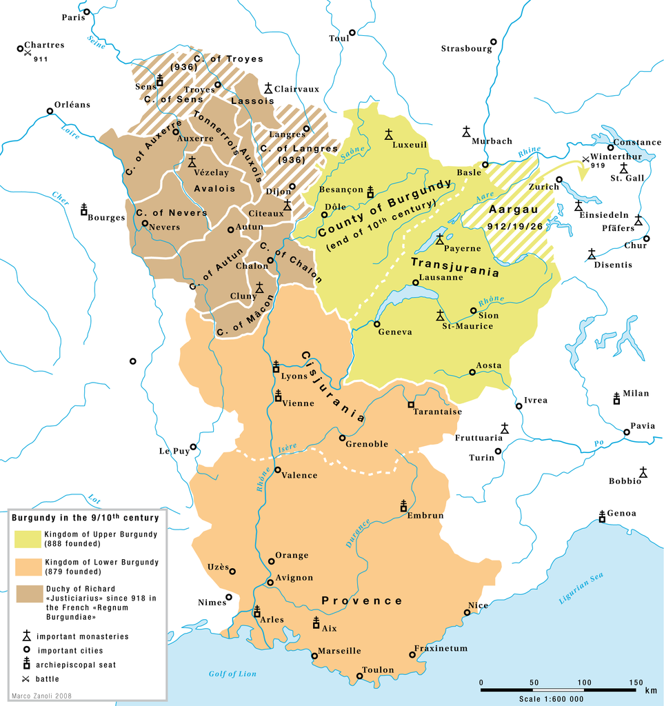
Burgundy in the 9th and 10th century
Description[modifier]
| Description |
English: Burgundy in the 9th and 10th century: The kingdoms of Upper-Burgundy, Lower-Burgundy and the Duchy of Richard the Justiciar in the French part of the old Burgundian Kindom. |
| Date | |
| Source | Travail personnel |
| Auteur | Marco Zanoli (Sidonius) |
| Autres versions |
|


Conditions d’utilisation[modifier]
You may use my work outside wikipedia for free as long as you name me as the author. If you would like to use my work in a print medium, please send me a specimen copy.
Contact me if you have questions regarding the license or if you want individual changes to the map (marco.zanoli at hotmail.ch). Ce fichier est sous la licence Creative Commons Attribution – Partage dans les Mêmes Conditions 4.0 International. Attribution: Marco Zanoli
|
Historique du fichier
Cliquer sur une date et heure pour voir le fichier tel qu'il était à ce moment-là.
| Date et heure | Vignette | Dimensions | Utilisateur | Commentaire | |
|---|---|---|---|---|---|
| actuel | 24 février 2018 à 14:14 | | 2 000 × 2 126 (538 kio) | Sidonius (d | contributions) | a few corrections |
| 4 juillet 2010 à 04:54 |  | 1 310 × 1 338 (192 kio) | DcoetzeeBot (d | contributions) | Remove watermark, add author and license data to image metadata, decrease filesize with pngcrush | |
| 13 février 2009 à 16:29 |  | 1 310 × 1 338 (319 kio) | Sidonius (d | contributions) | small corrections | |
| 13 février 2009 à 14:24 |  | 1 310 × 1 338 (318 kio) | Sidonius (d | contributions) | == Beschreibung == {{Information |Description={{EN|1=Burgundy in the 9th and 10th century: The kingdoms of Upper-Burgundy, Lower-Burgundy and the Duchy of Richard the Justiciar in the French part of the old Burgundian Kindom.}} |Source=Eigenes Werk (own w |
Vous ne pouvez pas remplacer ce fichier.
Utilisations locales du fichier
Les 11 pages suivantes utilisent ce fichier :
- Atlas of Switzerland
- User:J budissin/Uploads/BiH/2018 February 19-28
- User:Sidonius
- User:Zinneke/Nei Biller iwwer Lëtzebuerg/2018 February 19-28
- File:Karte Hoch- und Niederburgund.png
- File:Karte Hoch Niederburgund-FR.png
- File:Karte Hoch und Niederburgund-el.png
- File:Map Burgundian Kingdom 2 EN.png
- File:Map Burgundian Kingdom EN.png
- File:Map Kingdom Arelat AR.png
- File:Map Kingdom Arelat EN.png
Utilisations du fichier sur d’autres wikis
Les autres wikis suivants utilisent ce fichier :
- Utilisation sur af.wikipedia.org
- Utilisation sur ar.wikipedia.org
- Utilisation sur be.wikipedia.org
- Utilisation sur bg.wikipedia.org
- Utilisation sur bs.wikipedia.org
- Utilisation sur ca.wikipedia.org
- Utilisation sur cs.wikipedia.org
- Utilisation sur en.wikipedia.org
- Utilisation sur eo.wikipedia.org
- Utilisation sur es.wikipedia.org
- Utilisation sur et.wikipedia.org
- Utilisation sur eu.wikipedia.org
- Utilisation sur fr.wikipedia.org
Voir davantage sur l’utilisation globale de ce fichier.