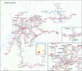
File:Karte Stadtbahn Karlsruhe.png
From Wikimedia Commons, the free media repository
Jump to navigation
Jump to search

Size of this preview: 691 × 599 pixels. Other resolutions: 277 × 240 pixels | 554 × 480 pixels | 886 × 768 pixels | 1,181 × 1,024 pixels | 2,362 × 2,048 pixels | 11,391 × 9,877 pixels.
Original file (11,391 × 9,877 pixels, file size: 38.36 MB, MIME type: image/png)
File information
Structured data
Captions
Captions
Add a one-line explanation of what this file represents
Summary[edit]
| Warning | The original file is very high-resolution. It might not load properly or could cause your browser to freeze when opened at full size. |
|---|
| DescriptionKarte Stadtbahn Karlsruhe.png |
English: Map of Stadtbahn Karlsruhe Deutsch: Karte der Stadtbahn Karlsruhe im Dezember 2015 |
|||||||||
| Date | ||||||||||
| Source |
Map was created by using |
|||||||||
| Creator |
|
|||||||||
| Permission (Reusing this file) |
Map data (c) OpenStreetMap (and) contributors, CC-BY-SA | |||||||||
| Geotemporal data | ||||||||||
| Bounding box |
|
|||||||||
| Georeferencing | View the georeferenced map in the Wikimaps Warper | |||||||||
Licensing[edit]
I, the copyright holder of this work, hereby publish it under the following license:
This file is licensed under the Creative Commons Attribution 3.0 Unported license.
- You are free:
- to share – to copy, distribute and transmit the work
- to remix – to adapt the work
- Under the following conditions:
- attribution – You must give appropriate credit, provide a link to the license, and indicate if changes were made. You may do so in any reasonable manner, but not in any way that suggests the licensor endorses you or your use.

|
This work is licensed under the Open Database License (summary).Open Database LicenseODbLhttp://opendatacommons.org/licenses/odbl/1.0/true |
File history
Click on a date/time to view the file as it appeared at that time.
| Date/Time | Thumbnail | Dimensions | User | Comment | |
|---|---|---|---|---|---|
| current | 15:43, 28 June 2021 |  | 11,391 × 9,877 (38.36 MB) | Pechristener (talk | contribs) | Mühlburger Tor richtig gestellt |
| 21:22, 22 June 2021 |  | 11,391 × 9,877 (38.43 MB) | Pechristener (talk | contribs) | Korrekturen und Nachführungen | |
| 06:17, 1 October 2016 |  | 3,006 × 2,606 (6.21 MB) | Pechristener (talk | contribs) | korr Schrift, Verkehrsverbundlogos entfernt | |
| 17:57, 10 August 2016 |  | 3,006 × 2,606 (6.18 MB) | Pechristener (talk | contribs) | Zugpaar am WE nach Herrenberg hinzugefügt | |
| 16:55, 8 August 2016 |  | 3,006 × 2,606 (6.16 MB) | Pechristener (talk | contribs) | Schriftgrösse | |
| 15:39, 17 July 2016 |  | 3,006 × 2,606 (6.23 MB) | Pechristener (talk | contribs) | location map ergänzt | |
| 06:54, 17 July 2016 |  | 3,006 × 2,606 (6.39 MB) | Pechristener (talk | contribs) | Auschnitte von Karlsruhe Innenstadt und Heilbronn hinzu | |
| 04:53, 17 July 2016 |  | 3,000 × 2,601 (6.61 MB) | Pechristener (talk | contribs) | reduced size, old version crashes the browser | |
| 09:52, 9 July 2016 |  | 5,942 × 5,151 (13.45 MB) | Pechristener (talk | contribs) | == {{int:filedesc}} == {{Information |Description ={{en|1=Map of Stadtbahn Karlsruhe}}{{de|1=Karte der Stadtbahn Karlsruhe im Dezember 2015}} |Source =Map was created by using * [http:... |
You cannot overwrite this file.
File usage on Commons
The following 28 pages use this file:
- User:Chumwa/OgreBot/Potential transport maps/2016 August 1-10
- User:Chumwa/OgreBot/Potential transport maps/2016 July 1-10
- User:Chumwa/OgreBot/Potential transport maps/2016 July 11-20
- User:Chumwa/OgreBot/Potential transport maps/2016 October 1-10
- User:Chumwa/OgreBot/Public transport information/2016 August 1-10
- User:Chumwa/OgreBot/Public transport information/2016 July 1-10
- User:Chumwa/OgreBot/Public transport information/2016 July 11-20
- User:Chumwa/OgreBot/Public transport information/2016 October 1-10
- User:Chumwa/OgreBot/Public transport information/2021 June 21-30
- User:Chumwa/OgreBot/Transport Maps/2016 August 1-10
- User:Chumwa/OgreBot/Transport Maps/2016 July 1-10
- User:Chumwa/OgreBot/Transport Maps/2016 July 11-20
- User:Chumwa/OgreBot/Transport Maps/2016 October 1-10
- User:Chumwa/OgreBot/Transport Maps/2021 June 21-30
- User:Chumwa/OgreBot/Travel and communication maps/2016 August 1-10
- User:Chumwa/OgreBot/Travel and communication maps/2016 July 1-10
- User:Chumwa/OgreBot/Travel and communication maps/2016 July 11-20
- User:Chumwa/OgreBot/Travel and communication maps/2016 October 1-10
- User:Clic/Nahverkehr in Deutschland/2021 June 21-30
- User:Ireas/OgreBot/Karlsruhe/2016 August 1-10
- User:Ireas/OgreBot/Karlsruhe/2016 July 1-10
- User:Ireas/OgreBot/Karlsruhe/2016 July 11-20
- User:Ireas/OgreBot/Karlsruhe/2016 October 1-10
- User:Ireas/OgreBot/Karlsruhe/2021 June 21-30
- User:Nordlicht8/Rail Germany/2016 August 1-10
- User:Nordlicht8/Rail Germany/2016 July 1-10
- User:Nordlicht8/Rail Germany/2021 June 21-30
- Category:Stadtbahn Karlsruhe
File usage on other wikis
The following other wikis use this file:
- Usage on de.wikipedia.org
- Usage on fr.wikipedia.org
- Usage on hu.wikipedia.org
- Usage on ja.wikipedia.org
- Usage on nl.wikipedia.org
- Usage on uk.wikipedia.org
- Usage on www.wikidata.org
Metadata
This file contains additional information such as Exif metadata which may have been added by the digital camera, scanner, or software program used to create or digitize it. If the file has been modified from its original state, some details such as the timestamp may not fully reflect those of the original file. The timestamp is only as accurate as the clock in the camera, and it may be completely wrong.
| Horizontal resolution | 55.11 dpc |
|---|---|
| Vertical resolution | 55.11 dpc |
| Software used |