File:Karte Streckenverlegung München Ost–Riem 1909.png
Jump to navigation
Jump to search
Size of this preview: 800 × 323 pixels. Other resolutions: 320 × 129 pixels | 640 × 258 pixels | 1,474 × 595 pixels.
Original file (1,474 × 595 pixels, file size: 1.25 MB, MIME type: image/png)
Captions
Captions
Add a one-line explanation of what this file represents
Summary
[edit]
| Description |
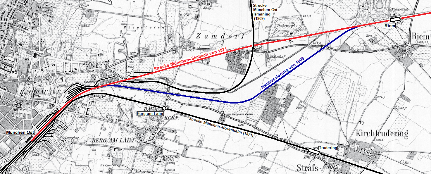
Deutsch: Die Karte zeigt die Verlegung der Bahnstrecke München–Simbach zwischen den Stationen München Ost und Riem im Jahr 1909, um das Baufeld für den Rangierbahnhof München Ost freizumachen. Die alte eingleisige Trasse von 1871 (rot) wurde durch eine weiter südlich verlaufende zweigleisige Trasse (blau) ersetzt. |
| Date | 1907, 1914, 2019 |
| Source |
Own work and File:Karte München und Vororte um 1910.jpg, using these pages from the Topographische Karte Bayern:
|
| Author | Maximilian Dörrbecker (Chumwa), Flummi-2011 |
Licensing
[edit]
This file is licensed under the Creative Commons Attribution-Share Alike 2.0 Generic license.
- You are free:
- to share – to copy, distribute and transmit the work
- to remix – to adapt the work
- Under the following conditions:
- attribution – You must give appropriate credit, provide a link to the license, and indicate if changes were made. You may do so in any reasonable manner, but not in any way that suggests the licensor endorses you or your use.
- share alike – If you remix, transform, or build upon the material, you must distribute your contributions under the same or compatible license as the original.
The Topographische Karte Bayern 1:25.000 sheets from 1907-1914 are in the Public Domain:
| This image is in the public domain according to German copyright law because it is part of a statute, ordinance, official decree or judgment (official work) issued by a German authority or court (§ 5 Abs.1 UrhG).
|
 |
This work is in the public domain in the United States because it was published (or registered with the U.S. Copyright Office) before January 1, 1929.
Public domain works must be out of copyright in both the United States and in the source country of the work in order to be hosted on the Commons. If the work is not a U.S. work, the file must have an additional copyright tag indicating the copyright status in the source country.
Note: This tag should not be used for sound recordings. |
File history
Click on a date/time to view the file as it appeared at that time.
| Date/Time | Thumbnail | Dimensions | User | Comment | |
|---|---|---|---|---|---|
| current | 21:35, 13 November 2022 | 1,474 × 595 (1.25 MB) | Flummi-2011 (talk | contribs) | Reverted to version as of 13:23, 4 January 2020 (UTC) | |
| 21:34, 13 November 2022 |  | 2,905 × 1,384 (310 KB) | Flummi-2011 (talk | contribs) | Daglfing als Bf | |
| 13:23, 4 January 2020 | 1,474 × 595 (1.25 MB) | Flummi-2011 (talk | contribs) | User created page with UploadWizard |
You cannot overwrite this file.
File usage on Commons
The following 4 pages use this file: