File:Karte Thüringer Kreis Homannsche Erben 1757 (cropped).jpg
Jump to navigation
Jump to search

Size of this preview: 800 × 455 pixels. Other resolutions: 320 × 182 pixels | 640 × 364 pixels | 1,024 × 582 pixels | 1,280 × 728 pixels | 2,130 × 1,211 pixels.
Original file (2,130 × 1,211 pixels, file size: 1.16 MB, MIME type: image/jpeg)
Captions
Captions
Add a one-line explanation of what this file represents
| Circuli Supe. Saxoniae Pars Meridionalis sive Ducatus Electoratus et Principatus Ducum Saxoniae… | ||||||
|---|---|---|---|---|---|---|
| Artist | ||||||
| Title |
Circuli Supe. Saxoniae Pars Meridionalis sive Ducatus Electoratus et Principatus Ducum Saxoniae… |
|||||
| Description |
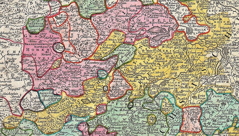
English: A fine example of the Homann Heirs map of Saxony, Germany. Covers from Berlin in the north, to Prague in the southeast and Efurt in the west. The map is filled with information including fortified cities, villages, roads, bridges, forests, battlefields, castles and topography. Title cartouche in the upper left quadrant features a wonderful mining vignette, the Greek god Hermes, and a warrior figure with a shield featuring the head of Medusa. Prepared in Nuremberg by the engravers Adam Friedrich Zürner and Zolman for issue in Homann Heirs’ Maior Atlas Scholasticus . |
|||||
| Date | 1757 (undated) | |||||
| Dimensions | height: 19 in (48.2 cm); width: 22 in (55.8 cm) | |||||
| Accession number |
Geographicus link: Saxoniae-hmhr-1757 |
|||||
| Source/Photographer |
Major Atlas Scholasticus Ex Triginta sex Generalibus et Specialibus Mappis Homannianis..., c. 1760.
|
|||||
| Permission (Reusing this file) |
|
|||||
| Other versions | ||||||

File history
Click on a date/time to view the file as it appeared at that time.
| Date/Time | Thumbnail | Dimensions | User | Comment | |
|---|---|---|---|---|---|
| current | 20:16, 16 March 2020 | | 2,130 × 1,211 (1.16 MB) | Bujo (talk | contribs) | File:1757 Homann Heirs Map of Saxony, Germany, and the Czech Republic - Geographicus - Saxoniae-hmhr-1757.jpg cropped 57 % horizontally, 72 % vertically using CropTool with precise mode. |
| 20:06, 16 March 2020 |  | 2,096 × 994 (971 KB) | Bujo (talk | contribs) | File:1757 Homann Heirs Map of Saxony, Germany, and the Czech Republic - Geographicus - Saxoniae-hmhr-1757.jpg cropped 58 % horizontally, 77 % vertically using CropTool with precise mode. |
You cannot overwrite this file.
File usage on Commons
The following 5 pages use this file:
- User:Derbrauni/NeuesDresden/2020 March 11-20
- User:Frze/Category:Dresden uploads/2020 March 11-20
- User:Magog the Ogre/Multilingual legend/2020 March 11-20
- File:1757 Homann Heirs Map of Saxony, Germany, and the Czech Republic - Geographicus - Saxoniae-hmhr-1757.jpg
- File:Karte Thüringer Kreis Homannsche Erben 1757 (cropped).jpg
.jpg)
File usage on other wikis
The following other wikis use this file:
- Usage on de.wikipedia.org
.jpg&oldid=601462966)