File:Karte der Landesteile Somalias.png
Jump to navigation
Jump to search

Size of this preview: 474 × 599 pixels. Other resolutions: 190 × 240 pixels | 380 × 480 pixels | 607 × 768 pixels | 810 × 1,024 pixels | 1,466 × 1,853 pixels.
Original file (1,466 × 1,853 pixels, file size: 117 KB, MIME type: image/png)
Captions
Captions
Add a one-line explanation of what this file represents
Summary
[edit]
| Description |
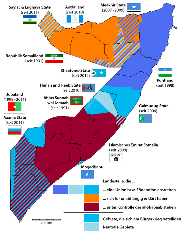
Deutsch: Karte der Landesteile Somalias
English: Map of states in Somalia
Español: Mapa de estados en Somalia
Français : Carte de l'État de la Somalie |
| Date | |
| Source |
This file was derived from: Somalie2011.png:  |
| Author |
|
| This is a retouched picture, which means that it has been digitally altered from its original version. Modifications: updated German version. The original can be viewed here: Somalie2011.png:
|
Licensing
[edit]
I, the copyright holder of this work, hereby publish it under the following license:
This file is licensed under the Creative Commons Attribution-Share Alike 3.0 Unported license.
- You are free:
- to share – to copy, distribute and transmit the work
- to remix – to adapt the work
- Under the following conditions:
- attribution – You must give appropriate credit, provide a link to the license, and indicate if changes were made. You may do so in any reasonable manner, but not in any way that suggests the licensor endorses you or your use.
- share alike – If you remix, transform, or build upon the material, you must distribute your contributions under the same or compatible license as the original.
Original upload log
[edit]
This image is a derivative work of the following images:
- File:Somalie2011.png licensed with Cc-by-sa-3.0
- 2011-07-29T18:10:08Z Deudora 719x896 (58192 Bytes)
Uploaded with derivativeFX
File history
Click on a date/time to view the file as it appeared at that time.
| Date/Time | Thumbnail | Dimensions | User | Comment | |
|---|---|---|---|---|---|
| current | 12:52, 25 June 2014 | | 1,466 × 1,853 (117 KB) | Kopiersperre (talk | contribs) | optipng |
| 21:10, 7 October 2013 |  | 1,466 × 1,853 (130 KB) | Chumwa (talk | contribs) | == {{int:filedesc}} == {{Information |Description={{fr|1=Carte de l'État de la Somalie}} |date=2012-10-07 {{fr|1=Karte der Landesteile Somalias}} |date=2012-10-07 |Source={{Derived from|Somalie2011.png|display=50}} |Date=2013-10-07 20:57 (UTC) |Author... |
You cannot overwrite this file.
File usage on Commons
The following page uses this file:
File usage on other wikis
The following other wikis use this file:
- Usage on be.wikipedia.org
- Usage on de.wikipedia.org
- Usage on en.wikipedia.org
- Usage on uk.wikipedia.org