File:Kent-52E511. Probably Roman. Weight. Steelyard weight. Front view. (FindID 279141).jpg
Jump to navigation
Jump to search
Size of this preview: 450 × 600 pixels. Other resolutions: 180 × 240 pixels | 360 × 480 pixels | 576 × 768 pixels | 768 × 1,024 pixels | 1,920 × 2,560 pixels.
Original file (1,920 × 2,560 pixels, file size: 961 KB, MIME type: image/jpeg)
Captions
Captions
Add a one-line explanation of what this file represents
Summary[edit]
.jpg&action=edit§ion=1)
| Kent-52E511. Probably Roman. Weight. Steelyard weight. Front view. | |||
|---|---|---|---|
| Photographer |
None, Geoff Burr, 2009-12-02 18:49:42 |
||
| Title |
Kent-52E511. Probably Roman. Weight. Steelyard weight. Front view. |
||
| Description |
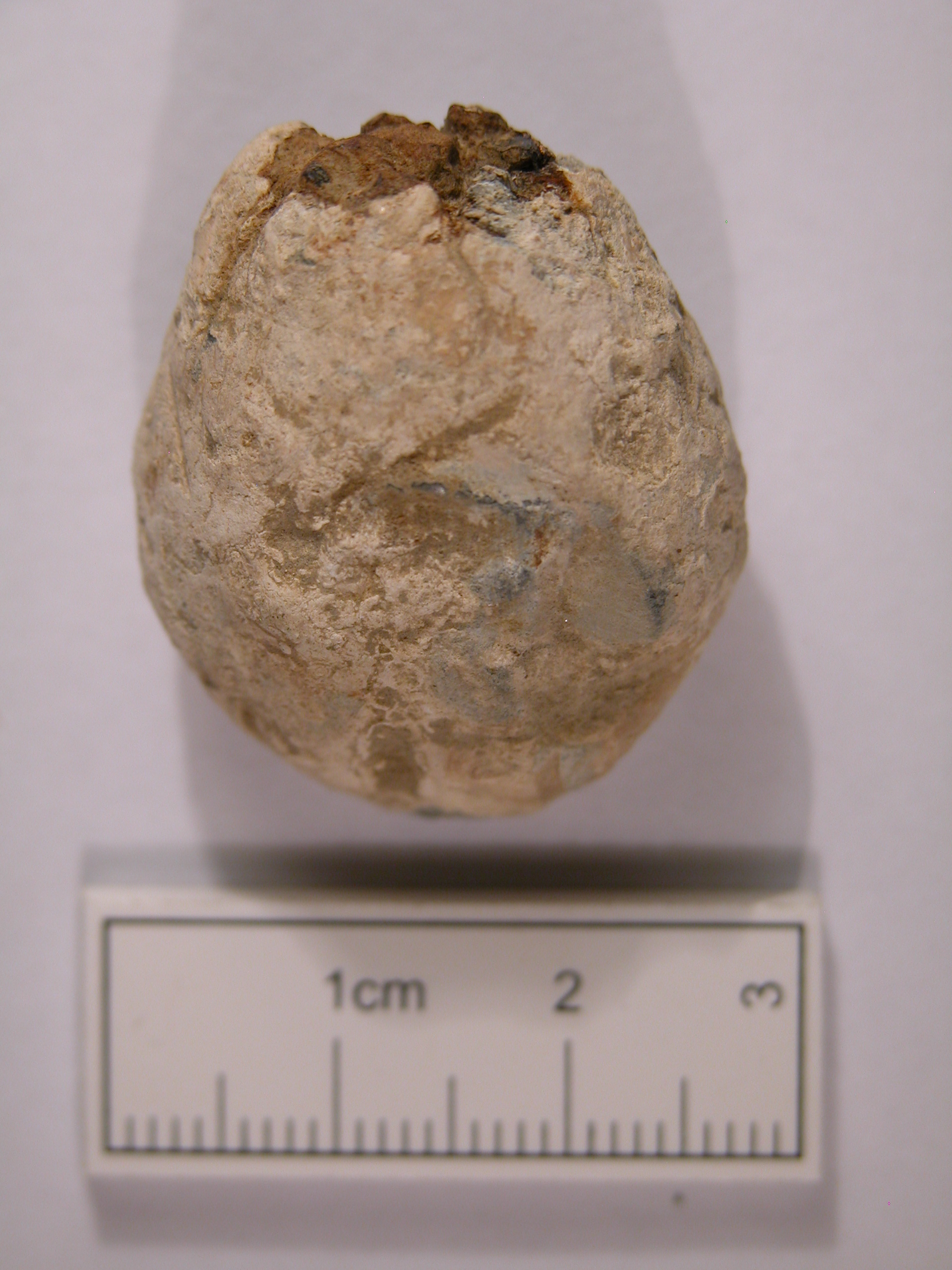
English: Age uncertain. Probably Roman. lead alloy, cast, oval probable steelyard weight. Length 31.3mm, Width 25.6mm, Thickness 17.5mm, Weight 61.9g. Flattened oval or 'pear drop' shape, plain lead weight with rusty remains of a probable suspension loop at the top. The steelyard was used throughout the Roman world and, being portable was employed by many street sellers and merchants. White powdery surface with a number of small dents and scratches inflicted by agricultural practices i.e. ploughing. Ref. Detector Finds 2, Gordon Bailey, Greenlight Publishing 1993, page 29-34 No. 9 and Roman Artefacts Found In Britain, Nigel Mills, Greenlight Publishing 1995, page 81 pic. M239a. |
||
| Depicted place | (County of findspot) West Sussex | ||
| Date | between 43 and 410 | ||
| Accession number |
FindID: 279141 Old ref: KENT-52E511 Filename: DSCN5050.JPG |
||
| Credit line |
|
||
| Source |
https://finds.org.uk/database/ajax/download/id/231156 Catalog: https://finds.org.uk/database/images/image/id/231156/recordtype/artefacts archive copy at the Wayback Machine Artefact: https://finds.org.uk/database/artefacts/record/id/279141 |
||
| Permission (Reusing this file) |
Attribution-ShareAlike License | ||
| Object location | | View this and other nearby images on: OpenStreetMap |
|---|
.jpg¶ms=050.930100_N_-000.282882_E_globe:Earth_class:object_type:object__&language=en)
Licensing[edit]
.jpg&action=edit§ion=2)
This file is licensed under the Creative Commons Attribution-Share Alike 2.0 Generic license.
Attribution: The Portable Antiquities Scheme/ The Trustees of the British Museum
- You are free:
- to share – to copy, distribute and transmit the work
- to remix – to adapt the work
- Under the following conditions:
- attribution – You must give appropriate credit, provide a link to the license, and indicate if changes were made. You may do so in any reasonable manner, but not in any way that suggests the licensor endorses you or your use.
- share alike – If you remix, transform, or build upon the material, you must distribute your contributions under the same or compatible license as the original.
File history
Click on a date/time to view the file as it appeared at that time.
| Date/Time | Thumbnail | Dimensions | User | Comment | |
|---|---|---|---|---|---|
| current | 08:32, 28 January 2017 | | 1,920 × 2,560 (961 KB) | Fæ (talk | contribs) | Portable Antiquities Scheme, KENT, FindID: 279141, roman, page 530, batch count 9526 |
You cannot overwrite this file.
File usage on Commons
The following page uses this file:
.jpg)
.jpg&oldid=544760995)