File:Kievan-rus-1015-1113-(en).png
跳转到导航
跳转到搜索
本预览的尺寸:488 × 599像素。 其他分辨率:195 × 240像素 | 391 × 480像素 | 626 × 768像素 | 834 × 1,024像素 | 2,166 × 2,659像素。
原始文件 (2,166 × 2,659像素,文件大小:440 KB,MIME类型:image/png)
说明
说明
添加一行文字以描述该文件所表现的内容
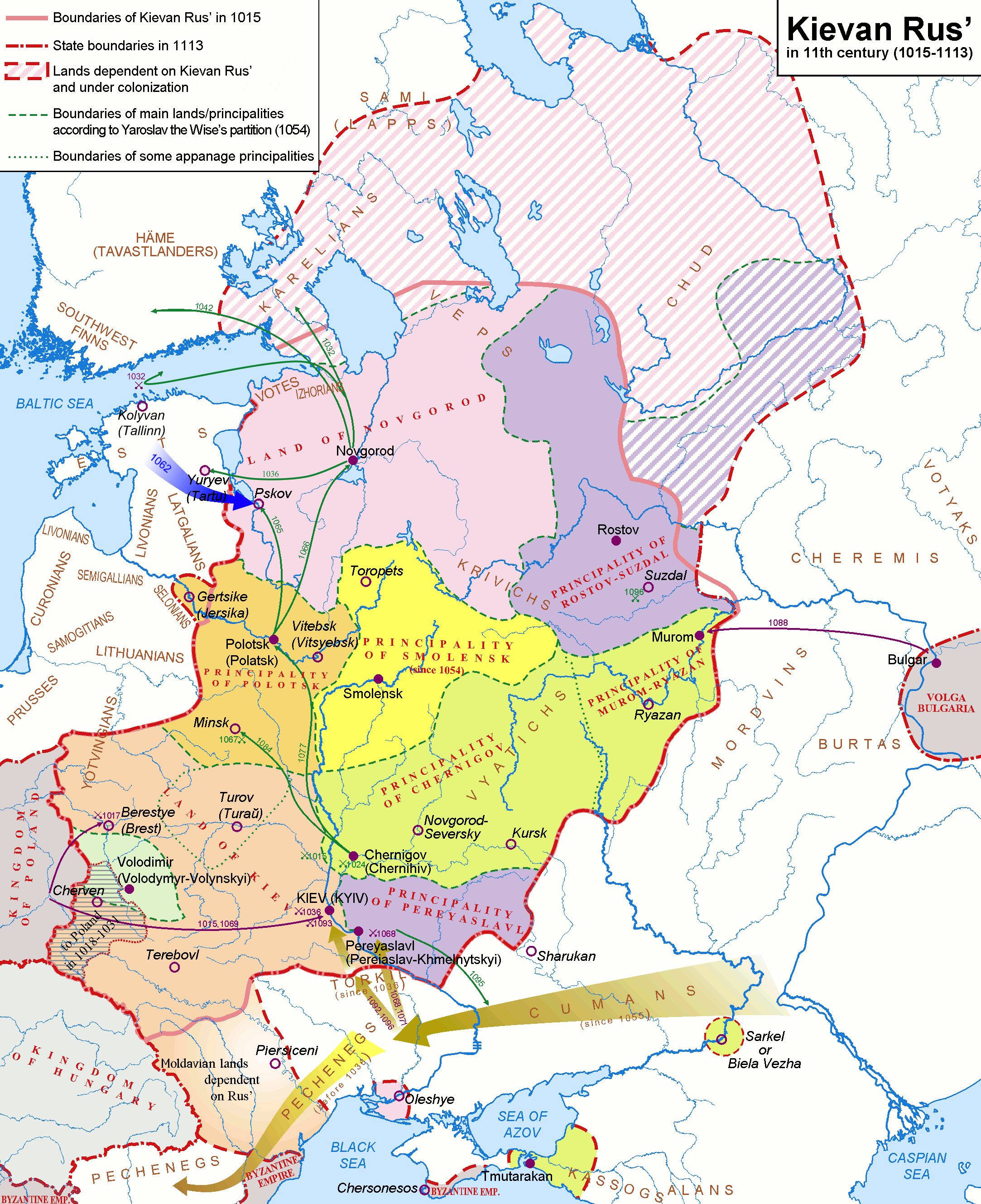
Map — Kievan Rus in 1015-1113 .
摘要[编辑]
| 描述 |
English: Map of the Kievan Rus' realm, 1015-1113 CE, of the medieval Rus' culture in Eastern Europe.
Deutsch: Karte - Das Kiewer Reich (»Kiewer Rus«) 1015-1113 (Englisch).
Русский: Карта — Киевская Русь в 1015-1113 гг. (по-Английски) |
| 日期 | |
| 来源 | http://commons.wikimedia.org/wiki/Image:Rus-1015-1113.png |
| 作者 |
Original version (russian): Koryakov Yuri English translation: Hellerick |
| 其他版本 |
Rus-1015-1113.png:  Kievan-rus-1015-1113.png: Kievan-rus-1015-1113.png:  Kievan-rus-1015-1113-(de).png: Kievan-rus-1015-1113-(de).png: .png) Kievan-rus-1015-1113-(hu).svg: Kievan-rus-1015-1113-(hu).svg: .svg) |
.png)
.png&action=edit§ion=1)

|
曾經在圖像本身中可見的歸屬信息,例如作者的姓名、電子郵件、網站或簽名,已移動到圖像元數據和/或圖像描述頁面。 這使圖像更易於重用且更不依賴語言,並使文本更易於處理和搜索。共享資源勸阻在圖像中放置可見的作者信息。
|

|
此map图片可使用矢量图形重新创建为SVG文件。这具有很多好处;更多信息请参见共享资源:待清理媒体。如果存在此图片的SVG格式,请将其上传,然后将此模板替换为
{{vector version available|新图片名称}}。
建议您将SVG命名为“Kievan-rus-1015-1113-(en).svg”,这样在使用Vector version available(或Vva)模板时就不需要填写新图片名称参数。 |
许可协议[编辑]
.png&action=edit§ion=2)
我,本作品著作权人,特此采用以下许可协议发表本作品:
本文件采用知识共享署名-相同方式共享 2.5 通用许可协议授权。
- 您可以自由地:
- 共享 – 复制、发行并传播本作品
- 修改 – 改编作品
- 惟须遵守下列条件:
- 署名 – 您必须对作品进行署名,提供授权条款的链接,并说明是否对原始内容进行了更改。您可以用任何合理的方式来署名,但不得以任何方式表明许可人认可您或您的使用。
- 相同方式共享 – 如果您再混合、转换或者基于本作品进行创作,您必须以与原先许可协议相同或相兼容的许可协议分发您贡献的作品。
文件历史
点击某个日期/时间查看对应时刻的文件。
.png&uselang=zh&dir=prev)
.png&uselang=zh&offset=20140226135705)
.png&uselang=zh&offset=&limit=20)
.png&uselang=zh&offset=&limit=50)
.png&uselang=zh&offset=&limit=100)
.png&uselang=zh&offset=&limit=250)
.png&uselang=zh&offset=&limit=500)
| 日期/时间 | 缩略图 | 大小 | 用户 | 备注 | |
|---|---|---|---|---|---|
| 当前 | 2018年3月28日 (三) 20:22 | | 2,166 × 2,659(440 KB) | Nihil scimus(留言 | 贡献) | Minor corrections: Byzantine Empire in Crimea, Moldvari lands (unter Hungarian rule before the Rus influence). |
| 2017年9月16日 (六) 12:08 |  | 2,166 × 2,659(593 KB) | Rosszkornyifog(留言 | 贡献) | Minor corrections: real Western frontiers of the Rus | |
| 2017年9月16日 (六) 11:48 |  | 2,193 × 2,686(604 KB) | Rosszkornyifog(留言 | 贡献) | Reverted to version as of 11:36, 16 September 2017 (UTC) | |
| 2017年9月16日 (六) 11:48 |  | 2,058 × 2,527(2.76 MB) | Rosszkornyifog(留言 | 贡献) | Per reliable sources | |
| 2017年9月16日 (六) 11:36 |  | 2,193 × 2,686(604 KB) | Rosszkornyifog(留言 | 贡献) | Reverted to version as of 21:48, 17 October 2012 (UTC) | |
| 2017年9月16日 (六) 11:30 |  | 2,166 × 2,659(593 KB) | Rosszkornyifog(留言 | 贡献) | Per reliable sources | |
| 2017年9月16日 (六) 11:13 |  | 2,166 × 2,659(593 KB) | Rosszkornyifog(留言 | 贡献) | Per reliable sources | |
| 2017年6月1日 (四) 08:40 |  | 2,166 × 2,659(248 KB) | ديفيد عادل وهبة خليل 2(留言 | 贡献) | Removed border by cropping 1 % horizontally and 1 % vertically using CropTool with precise mode. | |
| 2015年3月21日 (六) 00:03 |  | 2,193 × 2,686(446 KB) | Nug(留言 | 贡献) | Per reliable sources | |
| 2014年2月26日 (三) 13:57 |  | 2,193 × 2,686(224 KB) | Yurik1989(留言 | 贡献) | Reverted to version as of 20:05, 18 November 2010 |
您不可以覆盖此文件。
文件用途
以下6个页面使用本文件:
全域文件用途
以下其他wiki使用此文件:
- af.wikipedia.org上的用途
- ar.wikipedia.org上的用途
- ast.wikipedia.org上的用途
- azb.wikipedia.org上的用途
- bg.wikipedia.org上的用途
- bn.wikipedia.org上的用途
- ca.wikipedia.org上的用途
- cs.wikipedia.org上的用途
- da.wikipedia.org上的用途
- de.wikipedia.org上的用途
- de.wikibooks.org上的用途
- de.wikiversity.org上的用途
- el.wikipedia.org上的用途
- en.wikipedia.org上的用途
- History of Russia
- History of Lithuania
- Russia
- History of Belarus
- Chud
- List of tribes and states in Belarus, Russia and Ukraine
- Portal:Lithuania
- Principality of Polotsk
- Portal:Belarus
- Principality of Pereyaslavl
- Principality of Smolensk
- Kievan Rus'
- Talk:Kievan Rus'/Archive 2
- All-Russian nation
- User:CapLiber/sandbox
- User:Falcaorib
- User:Desutch2/Russia
- es.wikipedia.org上的用途
- et.wikipedia.org上的用途
查看本文件的更多全域用途。
.png)
元数据
.png&oldid=856345794)
分类:
- Maps of Balts
- Maps of Eastern Europe
- Maps of Kievan Rus
- Maps of Rus' principalities
- Maps of the history of Belarus
- Maps of the history of Estonia
- Maps of the history of Russia
- Maps of the history of Ukraine in the Middle Ages
- Maps of the history of Zakarpattia Oblast
- Maps showing history of the High Middle Ages
- English-language maps showing history
- Old maps of the history of Ukraine