File:Kievan-rus-1015-1113-(en).png
跳至導覽
跳至搜尋
預覽大小:488 × 599 像素。 其他解析度:195 × 240 像素 | 391 × 480 像素 | 626 × 768 像素 | 834 × 1,024 像素 | 2,166 × 2,659 像素。
原始檔案 (2,166 × 2,659 像素,檔案大小:440 KB,MIME 類型:image/png)
說明
說明
添加單行說明來描述出檔案所代表的內容
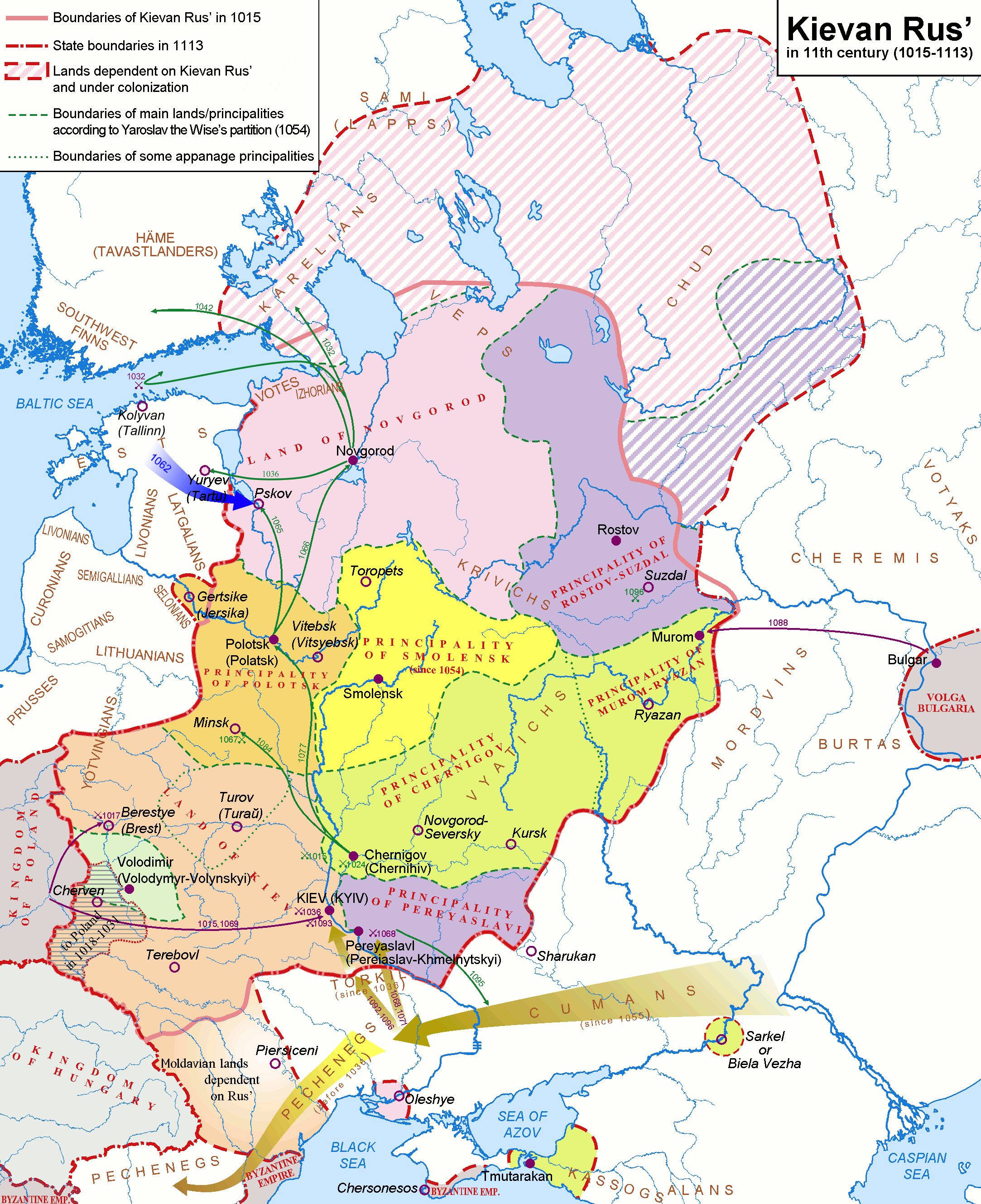
Map — Kievan Rus in 1015-1113 .
摘要[編輯]
| 描述 |
English: Map of the Kievan Rus' realm, 1015-1113 CE, of the medieval Rus' culture in Eastern Europe.
Deutsch: Karte - Das Kiewer Reich (»Kiewer Rus«) 1015-1113 (Englisch).
Русский: Карта — Киевская Русь в 1015-1113 гг. (по-Английски) |
| 日期 | |
| 來源 | http://commons.wikimedia.org/wiki/Image:Rus-1015-1113.png |
| 作者 |
Original version (russian): Koryakov Yuri English translation: Hellerick |
| 其他版本 |
Rus-1015-1113.png:  Kievan-rus-1015-1113.png: Kievan-rus-1015-1113.png:  Kievan-rus-1015-1113-(de).png: Kievan-rus-1015-1113-(de).png: .png) Kievan-rus-1015-1113-(hu).svg: Kievan-rus-1015-1113-(hu).svg: .svg) |
.png)
.png&action=edit§ion=1)

|
曾經在圖像本身中可見的歸屬信息,例如作者的姓名、電子郵件、網站或簽名,已移動到圖像元數據和/或圖像描述頁面。 這使圖像更易於重用且更不依賴語言,並使文本更易於處理和搜索。共享資源勸阻在圖像中放置可見的作者信息。
|

|
本圖片是以PNG、GIF或JPEG格式上傳。然而,其中包含的資料或訊息,應該重新建立成可縮放向量圖形(SVG)檔案,以更有效率或更準確的方式儲存。如有可能,請上傳本圖片的SVG格式版本。在上傳之後,請修改維基各姊妹計畫中所有使用舊版圖片的條目(列在圖像連結章節中),替換為新版圖片,並在舊圖片的描述頁中加入{{Vector version available|新圖片名稱.svg}}模板,同時移除本模板。
|
授權條款[編輯]
.png&action=edit§ion=2)
我,本作品的著作權持有者,決定用以下授權條款發佈本作品:
此檔案採用創用CC 姓名標示-相同方式分享 2.5 通用版授權條款。
- 您可以自由:
- 分享 – 複製、發佈和傳播本作品
- 重新修改 – 創作演繹作品
- 惟需遵照下列條件:
- 姓名標示 – 您必須指名出正確的製作者,和提供授權條款的連結,以及表示是否有對內容上做出變更。您可以用任何合理的方式來行動,但不得以任何方式表明授權條款是對您許可或是由您所使用。
- 相同方式分享 – 如果您利用本素材進行再混合、轉換或創作,您必須基於如同原先的相同或兼容的條款,來分布您的貢獻成品。
檔案歷史
點選日期/時間以檢視該時間的檔案版本。
.png&uselang=zh-tw&dir=prev)
.png&uselang=zh-tw&offset=20140226135705)
.png&uselang=zh-tw&offset=&limit=20)
.png&uselang=zh-tw&offset=&limit=50)
.png&uselang=zh-tw&offset=&limit=100)
.png&uselang=zh-tw&offset=&limit=250)
.png&uselang=zh-tw&offset=&limit=500)
| 日期/時間 | 縮圖 | 尺寸 | 使用者 | 備註 | |
|---|---|---|---|---|---|
| 目前 | 2018年3月28日 (三) 20:22 | | 2,166 × 2,659(440 KB) | Nihil scimus(留言 | 貢獻) | Minor corrections: Byzantine Empire in Crimea, Moldvari lands (unter Hungarian rule before the Rus influence). |
| 2017年9月16日 (六) 12:08 |  | 2,166 × 2,659(593 KB) | Rosszkornyifog(留言 | 貢獻) | Minor corrections: real Western frontiers of the Rus | |
| 2017年9月16日 (六) 11:48 |  | 2,193 × 2,686(604 KB) | Rosszkornyifog(留言 | 貢獻) | Reverted to version as of 11:36, 16 September 2017 (UTC) | |
| 2017年9月16日 (六) 11:48 |  | 2,058 × 2,527(2.76 MB) | Rosszkornyifog(留言 | 貢獻) | Per reliable sources | |
| 2017年9月16日 (六) 11:36 |  | 2,193 × 2,686(604 KB) | Rosszkornyifog(留言 | 貢獻) | Reverted to version as of 21:48, 17 October 2012 (UTC) | |
| 2017年9月16日 (六) 11:30 |  | 2,166 × 2,659(593 KB) | Rosszkornyifog(留言 | 貢獻) | Per reliable sources | |
| 2017年9月16日 (六) 11:13 |  | 2,166 × 2,659(593 KB) | Rosszkornyifog(留言 | 貢獻) | Per reliable sources | |
| 2017年6月1日 (四) 08:40 |  | 2,166 × 2,659(248 KB) | ديفيد عادل وهبة خليل 2(留言 | 貢獻) | Removed border by cropping 1 % horizontally and 1 % vertically using CropTool with precise mode. | |
| 2015年3月21日 (六) 00:03 |  | 2,193 × 2,686(446 KB) | Nug(留言 | 貢獻) | Per reliable sources | |
| 2014年2月26日 (三) 13:57 |  | 2,193 × 2,686(224 KB) | Yurik1989(留言 | 貢獻) | Reverted to version as of 20:05, 18 November 2010 |
無法覆蓋此檔案。
檔案用途
下列6個頁面有用到此檔案:
全域檔案使用狀況
以下其他 wiki 使用了這個檔案:
- af.wikipedia.org 的使用狀況
- ar.wikipedia.org 的使用狀況
- ast.wikipedia.org 的使用狀況
- azb.wikipedia.org 的使用狀況
- bg.wikipedia.org 的使用狀況
- bn.wikipedia.org 的使用狀況
- ca.wikipedia.org 的使用狀況
- cs.wikipedia.org 的使用狀況
- da.wikipedia.org 的使用狀況
- de.wikipedia.org 的使用狀況
- de.wikibooks.org 的使用狀況
- de.wikiversity.org 的使用狀況
- el.wikipedia.org 的使用狀況
- en.wikipedia.org 的使用狀況
- History of Russia
- History of Lithuania
- Russia
- History of Belarus
- Chud
- List of tribes and states in Belarus, Russia and Ukraine
- Portal:Lithuania
- Principality of Polotsk
- Portal:Belarus
- Principality of Pereyaslavl
- Principality of Smolensk
- Kievan Rus'
- Talk:Kievan Rus'/Archive 2
- All-Russian nation
- User:CapLiber/sandbox
- User:Desutch2/Russia
- User:Осла/Києвска Рус
- User:Falcaorib/Ukraine
- es.wikipedia.org 的使用狀況
- et.wikipedia.org 的使用狀況
檢視此檔案的更多全域使用狀況。
.png)
詮釋資料
.png&oldid=874960588)
分類:
- Maps of Balts
- Maps of Eastern Europe
- Maps of Kievan Rus
- Maps of Rus' principalities
- Maps of the history of Belarus
- Maps of the history of Estonia
- Maps of the history of Russia
- Maps of the history of Ukraine in the Middle Ages
- Maps of the history of Zakarpattia Oblast
- Maps showing history of the High Middle Ages
- English-language maps showing history
- Old maps of the history of Ukraine