File:Kingdom of Mann and the Isles-en.svg
Salta a la navegació
Salta a la cerca

Mida d'aquesta previsualització PNG del fitxer SVG: 571 × 600 píxels. Altres resolucions: 229 × 240 píxels | 457 × 480 píxels | 731 × 768 píxels | 975 × 1.024 píxels | 1.950 × 2.048 píxels | 1.297 × 1.362 píxels.
Fitxer original (fitxer SVG, nominalment 1.297 × 1.362 píxels, mida del fitxer: 209 Ko)
Llegendes
Llegendes
Afegeix una explicació d'una línia del que representa aquest fitxer
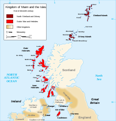
Map of the kingdom of Mann and the Isles, near the end of eleventh century
Resum
[modifica]| Descripció |
English: Map of the kingdom of Mann and the Isles, nearly the end of eleventh century.
Norðr: Shetland and Orkney
Sodor: Man and Hebrides Français : Carte du royaume de Man et des Îles, vers la fin du onzième siècle.
Norðr : Shetland et Orcades
Sodor : Man et Hebrides |
||
| Data | |||
| Font |
Own work based on: British Isles.svg, Mormaerdoms.png i Www.wesleyjohnston.com-users-ireland-maps-historical-map1014.gif |
||
| Autor | Sémhur | ||
| Altres versions |
Derivative works of this file: Kingdom of Mann and the Isles-es.svg
|
||
| Reconeixement (required by the license) | © Sémhur / Wikimedia Commons / | ||
| SVG | W3C-validity not checked. Aquesta imatge vectorial ha estat creada amb Inkscape .
|
||
| Atelier graphique |

| Posició de la càmera | | Aquesta i altres imatges properes a: OpenStreetMap |
|---|
Llicència
[modifica]
Jo, el titular dels drets d'autor d'aquest treball, el public sota les següents llicències:
| Copyleft: Aquesta és una obra d'art lliure: Podeu redistribuir-la i modificar-la sota els termes de la Llicència d'Art Lliure. Trobareu una còpia d'aquesta llicència al web Copyleft Attitude, així com en altres llocs web. |
Aquest fitxer està subjecte a la llicència Creative Commons Reconeixement i Compartir Igual 3.0 No adaptada, 2.5 Genèrica, 2.0 Genèrica i 1.0 Genèrica.
- Sou lliure de:
- compartir – copiar, distribuir i comunicar públicament l'obra
- adaptar – fer-ne obres derivades
- Amb les condicions següents:
- reconeixement – Heu de donar la informació adequada sobre l'autor, proporcionar un enllaç a la llicència i indicar si s'han realitzat canvis. Podeu fer-ho amb qualsevol mitjà raonable, però de cap manera no suggereixi que l'autor us dóna suport o aprova l'ús que en feu.
- compartir igual – Si modifiqueu, transformeu, o generareu amb el material, haureu de distribuir les vostres contribucions sota una llicència similar o una de compatible com l'original
Podeu seleccionar la llicència que vulgueu.
Historial del fitxer
Cliqueu una data/hora per veure el fitxer tal com era aleshores.
| Data/hora | Miniatura | Dimensions | Usuari/a | Comentari | |
|---|---|---|---|---|---|
| actual | 20:06, 26 des 2015 | | 1.297 × 1.362 (209 Ko) | Alphathon (discussió | contribucions) | Various minor corrections/tweaks |
| 10:06, 15 oct 2007 |  | 1.297 × 1.362 (208 Ko) | Sémhur (discussió | contribucions) | {{Information |Description=Map of the kingdom of Mann and the Isles, nearly the end of eleventh century |Source=Own work, from : * Map of British Isles * [[:Image:Mormaerdoms.png|Map of kingdoms of Scotland in the Middle Ages] |
No podeu sobreescriure aquest fitxer.
Ús del fitxer
Les 4 pàgines següents utilitzen aquest fitxer:
Ús global del fitxer
Utilització d'aquest fitxer en altres wikis:
- Utilització a af.wikipedia.org
- Utilització a be.wikipedia.org
- Utilització a bn.wikipedia.org
- Utilització a br.wikipedia.org
- Utilització a ca.wikipedia.org
- Utilització a cs.wikipedia.org
- Utilització a cy.wikipedia.org
- Utilització a da.wikipedia.org
- Utilització a de.wikipedia.org
- Utilització a el.wikipedia.org
- Utilització a en.wikipedia.org
- Hebrides
- Isle of Man
- History of the Isle of Man
- Norn language
- Scotland
- Outer Hebrides
- Kingdom of the Isles
- Slate Islands, Scotland
- Diocese of Sodor and Man
- User:Jnestorius/Regions with significant island landmass
- Earldom of Orkney
- Thorfinn the Mighty
- List of early Germanic peoples
- Norse–Gaels
- Scotland in the High Middle Ages
- Portal:Middle Ages/Selected article
- Portal:Middle Ages/Selected article/10
- Manx runestones
- Viking expansion
- King of Mann
- List of active separatist movements in Europe
- Viking activity in the British Isles
- Scottish island names
- Portal:Scotland/Selected article/2012
- Scandinavian Scotland
- Portal:Scotland/Selected article/Week 2, 2012
- Portal:Scotland/Selected article/2016
- Portal:Scotland/Selected article/Week 2, 2016
- Utilització a es.wikipedia.org
- Utilització a eu.wikipedia.org
Vegeu més usos globals d'aquest fitxer.